- Dolgesheim
-
Dolgesheim 

 DolgesheimLocation of Dolgesheim within Mainz-Bingen district
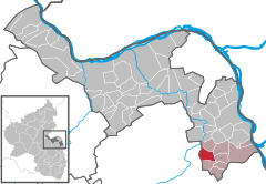
Coordinates 49°47′39″N 8°15′24″E / 49.79417°N 8.25667°ECoordinates: 49°47′39″N 8°15′24″E / 49.79417°N 8.25667°E Administration Country Germany State Rhineland-Palatinate District Mainz-Bingen Municipal assoc. Guntersblum Mayor Michael Schreiber (SPD) Basic statistics Area 6.55 km2 (2.53 sq mi) Elevation 199 m (653 ft) Population 933 (31 December 2010)[1] - Density 142 /km2 (369 /sq mi) Other information Time zone CET/CEST (UTC+1/+2) Licence plate MZ Postal code 55278 Area code 06733 Website www.dolgesheim.de Dolgesheim is an Ortsgemeinde – a municipality belonging to a Verbandsgemeinde, a kind of collective municipality – in the Mainz-Bingen district in Rhineland-Palatinate, Germany.
Contents
Geography
Location
Dolgesheim lies on the Gaustraße – Landesstraße (state road) 425 – halfway between Mainz and Worms. There is a further link by Bundesstraße 9 from Oppenheim by way of Dienheim, Uelversheim and Weinolsheim, or from Guntersblum by way of Eimsheim. Dolgesheim can also be reached from the A 61, Alzey interchange, by way of Gau-Odernheim and Hillesheim.
The greatest elevation is the Kreuzberg at 211 m above sea level.
History
Founded in the 5th century by Frankish tribes, the place known as Dulgisheim had its first documentary mention in 769 with a donation to the Lorsch Abbey. At this time, a Theo und Unsetz donated 2 morgens of cropland “in pago Wormat in Dulgisheimer Mark”. Early on, Dolgesheim belonged to the Counts of Leiningen, but passed in 1816 to the Grand Duchy of Hesse-Darmstadt.
Between 1825 and 1931, the building of the Gaustraße between Mainz and Worms brought good links to Rhenish Hesse’s cities. Dolgesheim was also thereby joined to the water (1907) and electricity (1913) networks early on.
Politics
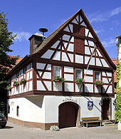 Town Hall
Municipal council
The council has since the municipal election held in 2004 been made up of 12 council members, 5 from the Bürgerliste Dolgesheim and 7 from the SPD.
Mayor
- Michael Schreiber (SPD)
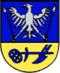
Coat of arms
The municipality’s arms might be described thus: Per fess at the nombril point azure an eagle displayed argent in each talon a sceptre sable with heads of the second, one a lily sceptre and the other a staff of oath, in base Or a plough of the first.
The silver eagle is the charge borne by the Counts of Leiningen and represents their former lordship over Dolgesheim. The lily sceptre stands for purity and the Church, while the staff of oath stands for the municipality’s duty and loyalty. The plough stands for the ancient working of the land and the municipality’s links with agriculture.
Culture and sightseeing
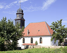 Evangelical Church
Buildings
- The church is the oldest building in the community. The foundation walls go back to the 13th century. After it was renovated it became a jewel among Evangelical churches in Rhenish Hesse.
- In the middle of the community, on the Gaustraße, stands the Town Hall, built in 1594.
- On the Kreuzberg (mountain) in more recent times, a Calvary cross has been put up.
References
- ^ "Bevölkerung der Gemeinden am 31.12.2010" (in German). Statistisches Landesamt Rheinland-Pfalz. 31 December 2010. http://www.statistik.rlp.de/fileadmin/dokumente/berichte/A1033_201022_hj_G.pdf.
External links
- Municipality’s official webpage (German)
- Information “Around Dolgesheim” (German)
- This article incorporates information from the German Wikipedia.
Appenheim · Aspisheim · Bacharach · Badenheim · Bingen am Rhein · Bodenheim · Breitscheid · Bubenheim · Budenheim · Dalheim · Dexheim · Dienheim · Dolgesheim · Dorn-Dürkheim · Eimsheim · Engelstadt · Essenheim · Friesenheim · Gau-Algesheim · Gau-Bischofsheim · Gensingen · Grolsheim · Guntersblum · Hahnheim · Harxheim · Heidesheim am Rhein · Hillesheim · Horrweiler · Ingelheim am Rhein · Jugenheim in Rheinhessen · Klein-Winternheim · Köngernheim · Lörzweiler · Ludwigshöhe · Manubach · Mommenheim · Münster-Sarmsheim · Nackenheim · Nieder-Hilbersheim · Nieder-Olm · Niederheimbach · Nierstein · Ober-Hilbersheim · Ober-Olm · Oberdiebach · Oberheimbach · Ockenheim · Oppenheim · Sankt Johann · Schwabenheim an der Selz · Selzen · Sörgenloch · Sprendlingen · Stadecken-Elsheim · Trechtingshausen · Uelversheim · Undenheim · Wackernheim · Waldalgesheim · Weiler bei Bingen · Weinolsheim · Welgesheim · Wintersheim · Wolfsheim · Zornheim · Zotzenheim Categories:
- Municipalities in Rhineland-Palatinate
- Mainz-Bingen geography stubs


Wikimedia Foundation. 2010.