- Deep Water, West Virginia
-
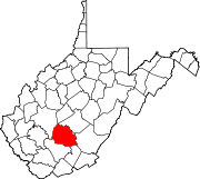
Deep Water — Census-designated place — Location within the state of West Virginia Coordinates: 38°7′36″N 81°15′49″W / 38.12667°N 81.26361°WCoordinates: 38°7′36″N 81°15′49″W / 38.12667°N 81.26361°W Country United States State West Virginia County Fayette Area[1] – Total 0.993 sq mi (2.6 km2) – Land 0.882 sq mi (2.3 km2) – Water 0.111 sq mi (0.3 km2) Population (2010)[2] – Total 280 – Density 282/sq mi (108.9/km2) Time zone Eastern (EST) (UTC-5) – Summer (DST) EDT (UTC-4) ZIP codes FIPS code GNIS feature ID 1554279[3] Deep Water, also known historically as Deepwater,[3] is an unincorporated census-designated place on the Kanawha River in Fayette County, West Virginia, United States. As of the 2010 census, its population was 280.[2] It is best known as the starting point of the Deepwater Railway founded in 1898 by William N. Page, which was merged to create the Virginian Railway in 1907.
Located near the head of navigation of the Kanawha River just a short distance downstream from Kanawha Falls, it may have been named for that reason. However, according to local legend as recounted by H. Reid in The Virginian Railway (Kalmbach, 1961), it was named by Squire James Galsepy Kincaid and other locals on a rainy day in 1871 as a commentary on the standing groundwater outside the new post office along Loup Creek.
References
- ^ "US Gazetteer files: 2010, 2000, and 1990". United States Census Bureau. 2011-02-12. http://www.census.gov/geo/www/gazetteer/gazette.html. Retrieved 2011-04-23.
- ^ a b "American FactFinder". United States Census Bureau. http://factfinder2.census.gov. Retrieved 2011-05-14.
- ^ a b Geographic Names Information System. "Geographic Names Information System entry for Deep Water (Feature ID #1554279)". http://geonames.usgs.gov/pls/gnispublic/f?p=gnispq:3:::NO::P3_FID:1554279. Retrieved 2007-03-09.
Municipalities and communities of Fayette County, West Virginia Cities Montgomery‡ | Mount Hope | Oak Hill | Smithers‡
Towns Ansted | Fayetteville | Gauley Bridge | Meadow Bridge | Pax | Thurmond
CDPs Beards Fork | Boomer | Charlton Heights | Deep Water | Dixie‡ | Falls View | Glen Ferris | Glen Jean | Hico | Hilltop | Kimberly | Kincaid | Minden | Mount Carbon | Page | Powellton | Prince | Scarbro
Unincorporated
communitiesAgnew | Alloy | Alta | Beckwith | Belva‡ | Cannelton | Carlisle | Chimney Corner | Clifftop | Cunard | Danese | Dothan | Elkridge | Fayette | Harvey | Hopewell | Jodie | Kanawha Falls | Kilsyth | Kingston | Landisburg | Lansing | Lawton | Layland | Lochgelly | Long Branch | Lookout | Mahan | Maplewood | Midway | Montgomery Heights | Mossy | Mount Olive | Nallen‡ | Newtown | North Page | Pine Grove | Price Hill‡ | Ramsey | Redstar | Robson | Russellville | Shawver‡ | Sewell | Spring Dale | Summerlee | Victor | Whipple | Winona
Footnotes ‡This populated place also has portions in an adjacent county or counties
Categories:- Fayette County, West Virginia geography stubs
- Census-designated places in West Virginia
- Populated places in Fayette County, West Virginia
- Kanawha River
Wikimedia Foundation. 2010.


