- Mossy, West Virginia
-
Mossy, West Virginia — Unincorporated community — 
 Mossy, West Virginia
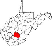
Coordinates: 37°58′34″N 81°16′54″W / 37.97611°N 81.28167°WCoordinates: 37°58′34″N 81°16′54″W / 37.97611°N 81.28167°W Country United States State West Virginia County Fayette Elevation 1,417 ft (432 m) Time zone Eastern (EST) (UTC-5) – Summer (DST) EDT (UTC-4) Area code(s) 304 & 681 GNIS feature ID 1543600[1] Mossy is an unincorporated community in Fayette County, West Virginia, United States. Mossy is located off exit 60 on the West Virginia Turnpike and is west of Oak Hill. As of 1993, the community had an Exxon gas station, a motel, and a restaurant, all owned by Teddy Gray or his relatives.[2]
References
- ^ U.S. Geological Survey Geographic Names Information System: Mossy, West Virginia
- ^ Youngblood, Ed (July 1993). "Stopping in Mossy". American Motorcyclist 47 (7): 92.
Municipalities and communities of Fayette County, West Virginia Cities Montgomery‡ | Mount Hope | Oak Hill | Smithers‡
Towns Ansted | Fayetteville | Gauley Bridge | Meadow Bridge | Pax | Thurmond
CDPs Beards Fork | Boomer | Charlton Heights | Deep Water | Dixie‡ | Falls View | Glen Ferris | Glen Jean | Hico | Hilltop | Kimberly | Kincaid | Minden | Mount Carbon | Page | Powellton | Prince | Scarbro
Unincorporated
communitiesAgnew | Alloy | Alta | Beckwith | Belva‡ | Cannelton | Carlisle | Chimney Corner | Clifftop | Cunard | Danese | Dothan | Elkridge | Fayette | Harvey | Hopewell | Jodie | Kanawha Falls | Kilsyth | Kingston | Landisburg | Lansing | Lawton | Layland | Lochgelly | Long Branch | Lookout | Mahan | Maplewood | Midway | Montgomery Heights | Mossy | Mount Olive | Nallen‡ | Newtown | North Page | Pine Grove | Price Hill‡ | Ramsey | Redstar | Robson | Russellville | Shawver‡ | Sewell | Spring Dale | Summerlee | Victor | Whipple | Winona
Footnotes ‡This populated place also has portions in an adjacent county or counties
Categories:- Populated places in Fayette County, West Virginia
- Unincorporated communities in West Virginia
- Fayette County, West Virginia geography stubs


Wikimedia Foundation. 2010.