- Kanawha River
Geobox|River
name = Kanawha River
native_name =
other_name =
other_name1 =
image_size = 300
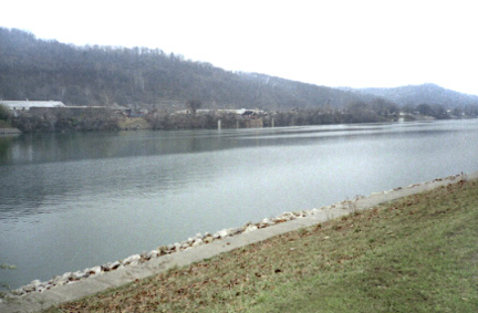
image_caption = Kanawha River atSt. Albans, West Virginia
country = United States
country_
state = West Virginia
state_
region_type = Counties
region = Fayette
region1 = Kanawha
region2 = Mason
region3 = Putnam
district =
district1 =
city =
city1 =
length_imperial = 97
length_note =
watershed_imperial = 12236
watershed_note =
discharge_location = Kanawha Falls at Glen Ferris, WV
discharge_average_imperial = 17000
discharge_max_imperial = 82800
discharge_max_note = (1987)
discharge_min_imperial = 4660
discharge_min_note = (1976)
discharge_note =United States Geological Survey ; [http://waterdata.usgs.gov/nwis/uv?03193000 USGS 03193000 KANAWHA RIVER AT KANAWHA FALLS, WV] ; retrieved April 19, 2008.]
source_name = New River
source_location = Ashe County
source_district =
source_region =
source_state = NC
source_country =
source_lat_d = 36
source_lat_m = 32
source_lat_s = 45
source_lat_NS = N
source_long_d = 81
source_long_m = 21
source_long_s = 09
source_long_EW = W
source_elevation_imperial = 2546
source_length_imperial =
source_note =gnis|1552301|New River]
source1_name =Gauley River
source1_location = Three Forks of Gauley
source1_district =
source1_region = Pocahontas County
source1_state = WV
source1_country =
source1_lat_d = 38
source1_lat_m = 24
source1_lat_s = 33
source1_lat_NS = N
source1_long_d = 80
source1_long_m = 14
source1_long_s = 17
source1_long_EW = W
source1_elevation_imperial = 2917
source1_length_imperial =
source1_note =gnis|1551216|Gauley River]
source_confluence_location = Gauley Bridge
source_confluence_district =
source_confluence_region =
source_confluence_state = WV
source_confluence_country =
source_confluence_lat_d = 38
source_confluence_lat_m = 09
source_confluence_lat_s = 42
source_confluence_lat_NS = N
source_confluence_long_d = 81
source_confluence_long_m = 11
source_confluence_long_s = 47
source_confluence_long_EW = W
source_confluence_elevation_imperial = 653
mouth_name =Ohio River
mouth_location = Point Pleasant
mouth_district =
mouth_region =
mouth_state = WV
mouth_country =
mouth_lat_d = 38
mouth_lat_m = 50
mouth_lat_s = 16
mouth_lat_NS = N
mouth_long_d = 82
mouth_long_m = 08
mouth_long_s = 34
mouth_long_EW = W
mouth_elevation_imperial = 538
mouth_note =Gnis|1551620|Kanawha River]
tributary_left = Coal River
tributary_left1 =
tributary_right = Elk River
tributary_right1 =Pocatalico River
free_name =
free_value =
map_size = 300
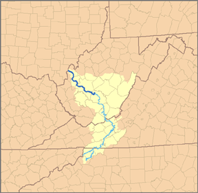
map_caption = Map of the Kanawha River and itsNew River tributary, with the Kanawha River highlighted.The Kanawha River (pronounced "ka-NAW-ah" or "kuh-NAW" and earlier, "kuh-NOIE") is a tributary of the
Ohio River , approximately 97 mi (156 km) long, in theU.S. state ofWest Virginia . The largest inland waterway in West Virginia, it has formed a significant industrial region of the state since the middle of the 19th century.It is formed at the town of Gauley Bridge in northwestern Fayette County, approximately 35 mi (56 km) SE of Charleston, by the confluence of the New and Gauley rivers. It flows generally northwest, in a winding course on the unglaciated
Allegheny Plateau , through Fayette, Kanawha, Putnam and Mason Counties, past the cities of Charleston and St. Albans and numerous smaller communities. It joins the Ohio at Point Pleasant.The river valley contains significant deposits of
coal andnatural gas . In colonial times, the wildly fluctuating level of the river prevented its use for transportation. The removal of boulders and snags on the lower river in the 1840s allowed navigation, extended after the construction of locks and dams starting in 1875. The river is now navigable to Deepwater, an unincorporated community about 20 miles upriver from Charleston. A thriving chemical industry along its banks provides a significant part of the economy of West Virginia.Tributaries
In addition to the New and Gauley Rivers, the Kanawha is joined at Charleston by the Elk River, at St. Albans by the Coal River, and at Poca by the
Pocatalico River .List of cities and towns along the Kanawha River
Variant names
According to the
Geographic Names Information System , the Kanawha River has also been known as:Highways
*
Interstate 64 crosses the Kanawha four times on major bridges in the Charleston vicinity.ee also
*
List of West Virginia rivers
*Little Kanawha River
*Kanawha River Valley AVA , anAmerican Viticultural Area
* USS "Kanawha" (AO-1) — a fleet oiler built in 1914.
* "Kanawha" a steam-powered luxuryyacht built in 1899 which was owned by Henry Huttleston Rogers, developer of [coal] andrailroad properties in southern West Virginia, including the $40 million dollarVirginian Railway
* TheGeneral Frank M. Coxe (ship) was built in Charleston on the Kanawha River in 1922, by the Charles Ward Engineering Works, served as an Army transport vessel and later a cruise ship on San Francisco Bay. It is now preserved as a floating restaurant inBurlingame, California , just south of San Francisco.Further reading
Arthur Benke & Colbert Cushing, "Rivers of North America". Elsevier Academic Press, 2005 ISBN 0-12-088253-1
Rhodes, Captain Rick, "The Ohio River in American History and Voyaging on Today's River" has a chapter on the Kanawha River. Heron Island Guides, 2007, ISBN 978-0-9665866-33
References

Wikimedia Foundation. 2010.