- North Point Douglas
-
North Point Douglas National Historic Site of Canada Province Manitoba Established 1812 Website collection of photos of the neighbourhood North Point Douglas is a small neighbourhood located in the city of Winnipeg, Canada.
North Point Douglas comprises the northern portion of a peninsula of the Red River. Its boundaries are Main Street (west), Redwood Avenue (north), the Red River (east), and the Canadian Pacific Railway mainline (south), which bisects the peninsula. The southern portion of the peninsula is the neighborhood of South Point Douglas (which is also considered part of Downtown Winnipeg.) Together, these two neighborhoods are known simply known as "Point Douglas". In 2001, North Point Douglas had a population of 2,260.
North Point Douglas is one of the Winnipeg's oldest neighbourhoods. Today, North Point Douglas boasts two of Winnipeg's oldest houses - Barber House and Ross House Museum. It is also considered part of Winnipeg's fabled North End.
Contents
History
The eastern point of the neighbourhood was a traditional gathering place for Aboriginal tribes for ceremonial rites (while The Forks nearby was traditionally used for trading purposes). This is believed to have occurred prior to European contact, and continued until urbanization in the 1870s.
In 1812, this first group of Selkirk Settlers arrived in Point Douglas and began raising wheat crops on the point and along the Red River, becoming the first agrarian colony west of the Great Lakes.
As the Red River Colony (as the Winnipeg region was known) grew, a small cluster of commercial establishments developed on the Fort Garry road at Point Douglas by 1862, notably those of William Fonseca and Edmond Barber. After the incorporation of the City of Winnipeg in 1873, Point Douglas developed a neighborhood. Several notable citizens resided there, including merchant James Ashdown and Manitoba premier John Norquay. Among the houses of these men, there developed more modest cottages, industry such as Brown and Rutherford, a lumber company established in Point Douglas in 1872.
In 1881, Point Douglas was selected as the location that the Canadian Pacific Railway would cross the Red River. This move solidified Point Douglas as a choice location for industrial firms, who could take advantage of proximity to the railway. With the railroad completed by 1885, Winnipeg experienced an intense period of growth, and by 1914, Point Douglas had become a densely-populated working-class neighbourhood, with many immigrants from Eastern Europe.
North Point Douglas today
North Point Douglas continues to be primarily a residential neighbourhood, but is also home to commercial and industrial uses, with industry located mainly on the south side of the neighbourhood along the CPR tracks, and commercial establishments on the western side, along Main Street—one of the city's busiest thoroughfares.
North Point Douglas is located immediately north of Winnipeg's downtown, and is considered part of Winnipeg's inner city. It has faced many of the same challenges that have characterized the North American city in the postwar decades: population and economic decline, crime, drug abuse, and a lack of investment. In recent years, the neighbourhood has begun to stabilize, through efforts by community groups like the Point Douglas Residents Committee and North End Community Renewal Corporation, and through new and long-time residents renovating properties.
North Point Douglas has begun to develop a reputation an attractive, quiet, character neighbourhood. As a result, a small number of artists and "Bohemians" are moving to the neighbourhood.
Ross House
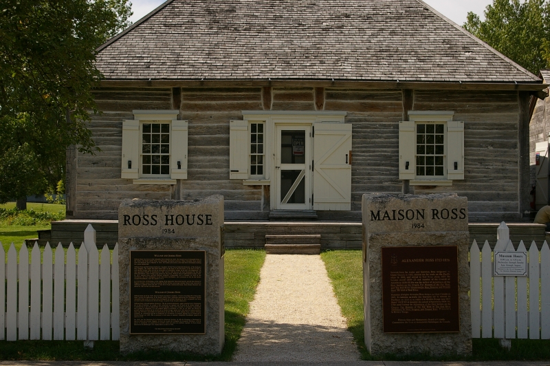
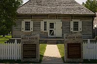 Ross House Museum
History of Ross House
William and Jemima Ross originally built Ross House on the shores of the Red River at the foot of Market Avenue. William's father Alexander had provided the land. At one time the Ross home became the first post office west of Thunder Bay other than those run by the Hudson's Bay Company. Well after the Ross family had finished using the house it was used as an office for a construction company. In 1949, the Manitoba Historical Society, in conjunction with the City of Winnipeg, took possession of Ross House and moved it to Higgins Avenue, across from the former Canadian Pacific Railway passenger station.
Ross House had its beginnings in 1852 when construction commenced on William Ross's log home. Ross was appointed Post Master in 1855 by the Council of Assiniboia and he operated the post office from his home. The house was originally located near the banks of the Red River at the foot of Market Avenue. In 1949, the Manitoba Historical Society, along with the City of Winnipeg, took possession of Ross House and moved it to Higgins Avenue across from the CPR Station. In 1984 it was moved to its present location on Meade Street North in Point Douglas Heritage Park, in the Joe Zuken Heritage Park.
Ross House is important because it was the first Post Office in Western Canada. It provides a glimpse into the operation of an early postal service, as well as into the lives of the Ross family in particular and 1850s homestead life in general.
The Ross House Museum is owned by the City of Winnipeg, and operated by the Manitoba Historical Society. The Society is responsible for the collection and display of the artifacts in Ross House, and provides personnel to operate the Museum.
The museum was moved to its current location at 140 Meade Street (Joe Zuken Heritage Park, Point Douglas) in 1984. The construction of Ross House is a prime example of a Red River frame building. The building itself is as much a part of the Museum as the artifacts it contains. It is made almost entirely of oak timber. All the logs used for construction were hand carved. The Museum hosts an interpretive exhibit as well as rooms set to reflect the life of the Ross family when their home served as the post office.
source: http://www.mhs.mb.ca/info/museums/ross/index.shtml
Barber House
 Barber House
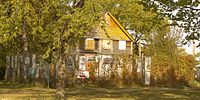
Barber House 99 Euclid Avenue
The residence remains as a rare urban example of Red River Frame style construction, using squared logs cut and hewn by its builders from local tree growth. Built around 1862, this historic structure has been designated a Grade 2 Heritage Building by the City of Winnipeg and the Province of Manitoba.
There is a great deal of myth surrounding the E.L. Barber House. The tradition generally states that after a brief stint as governor of the Dakota Territory, Edmond Lorenzo Barber joined his cousin in a profitable business venture that expanded to the Red River in 1860. Barber became prominent in business and social affairs. He owned a great deal of property in Point Douglas, but never made the fortune he anticipated on the property. He and his wife and five children remained at their home as the neighbourhood grew up around them. At the time of his death in 1909, the house was assessed for a value of only $750.00 and Barber's total wealth at $2,319.00.
Little is known about the actual construction of the Barber House. The house was probably set into a stone foundation with perhaps a root cellar for storage. The frame and horizontal logs were probably squared oak logs. As oak was the foremost material for construction and the supply of oak on the plains was somewhat limited, the logs were probably floated down from another location. The frame followed the normal method of construction, which had been used cross the country by fur traders and settlers alike. The Barber House was constructed with considerable skill for the horizontal logs were set in very straight and there was good attention to detail in the finishing.
There have been many changes in the house over the years, but these are all impossible to document because all the additions to the rear and all the interior alterations were done without the benefit of a single building permit.
Previous attempts ending 1988 were made to restore the Barber House. It has since stood empty and unused, partially rebuilt but however unprotected from the elements. In 1993, the structure was damaged by fire and due to arson and vandalism, and again in 2010. Although the house is surrounded by a chain link fence, there still is a concern for its security.
Source: http://www.heritagewinnipeg.com/houses/barber.htm
links
Point Douglas electoral district
Neighbourhoods in Winnipeg Agassi · Airport · Alpine Place · Amber Trails · Archwood · Armstrong Point · Beaumont · Betsworth · Birchwood · Booth · Broadway–Assiniboine · Brockville · Brooklands · Bruce Park · Buchanan · Burrows–Keewatin · Burrows Central · Canterbury Park · Centennial · Central Park · Central St Boniface · Chalmers · Charleswood · Chinatown · Cloutier Drive · Colony · Crescent Park · Crescentwood · Crestview · Dakota Crossing · Daniel McIntyre · Deer Lodge · Dufferin · Dufresne · Eaglemere · Earl Grey · East Elmwood · East Kildonan · Ebby–Wentworth · Edgeland · Elm Park · Elmhurst · Elmwood · Eric Coy · Exchange District · Fort Richmond · Fort Rouge · Garden City · Glendale · Glenelm · Glenwood · Grant Park · Grassie · Heritage Park · Holden · Inkster–Faraday · Inkster Gardens · Island Lakes · J.B. Mitchell · Jameswood · Jefferson · Kensington · Kern Park · Kil-cona Park · Kildare–Redonda · Kildonan Drive · King Edward · Kingston Crescent · Kirkfield · Lavalee · Leila–McPhillips Triangle · Linden Woods · Logan–CPR · Lord Roberts · Lord Selkirk Park · Luxton · Maginot · Mandalay West · Margaret Park · Marlton · Mathers · Maybank · McMillan · Meadowood · Meadows · Melrose · Minnetonka · Minto · Mission Gardens · Montcalm · Munroe East · Munroe West · Mynarski · Niakwa Park · Niakwa Place · Norberry · Normand Park · North Point Douglas · North St Boniface · Norwood East · Norwood West · Old Tuxedo · Parc La Salle · Peguis · Pembina Strip · Point Road · Portage–Ellice · Pulberry · Radisson · Richmond Lakes · Richmond West · Ridgedale · Ridgewood South · River–Osborne · River East · River Heights · River Park South · River West Park · Riverbend · Rivergrove · Riverview · Robertson · Roblin Park · Rockwood · Roslyn · Rosser–Old Kildonan · Rossmere–A · Rossmere–B · Royalwood · Sargent Park · Seven Oaks · Seven Oaks · Shaughnessy Park · Silver Heights · Sir John Franklin · South Point Douglas · South Portage · South Tuxedo · Southboine · Southdale · Southland Park · Spence · Springfield North · Springfield South · St. George · St. James-Assiniboia · St. John's Park · St. John's · St. Matthews · St. Norbert · St. Vital · Perimeter South · Sturgeon Creek · Talbot–Grey · Templeton–Sinclair · The Maples · Tissot · Transcona South · Trappistes · Tuxedo · Tyndall Park · University · Valhalla · Valley Gardens · Varennes · Varsity View · Vialoux · Victoria Crescent · Victoria West · Vista · Waverley Heights · Wellington Crescent · West Alexander · West Broadway · West Wolseley · Westdale · Weston · Westwood · Whyte Ridge · Wildwood · Wilkes South · William Whyte · Victoria West · Windsor Park · Wolseley · Woodhaven · Worthington
Coordinates: 49°54′32″N 97°07′42″W / 49.90889°N 97.12833°W
Categories:- Neighbourhoods in Winnipeg
- Historic districts in Canada
- National Historic Sites in Manitoba

Wikimedia Foundation. 2010.