- Osborne Village
-
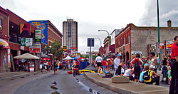
Osborne Village — Neighbourhood — Osborne street during Canada Day, 2006 Country  Canada
Province  Manitoba
City  Winnipeg
Osborne Village is a neighbourhood of Winnipeg, Manitoba, Canada. It derives its name from Osborne Street (Winnipeg Route 62), which runs through the centre of the village area.
Contents
History
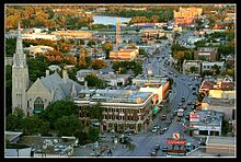
Osborne Street was named after Lieutenant Colonel William Osborne Smith (1833–1887) the first commanding officer of Military District 10, which included the city of Winnipeg. The north part of Osborne street was adjacent to the first Fort Osborne Barracks, on the site of which is now the Provincial Legislature. Osborne Village is among Winnipeg’s oldest neighborhoods. It has changed greatly over the last hundred years but its rich history is still evident in the architectural details of many of its buildings, as well as in the overall pattern of settlement which has come to embody this unique neighborhood.
Osborne Village is one of several neighborhoods that comprise Fort Rouge, an area that was amalgamated in to the city of Winnipeg as Ward 1 in 1882. The population of the area at that time was only 150 but rapidly developed overt the years. By 1900, it grew to a population in the thousands and by 1910, to a population in the tens of thousands.
The first streetcar, known as “The Parkline” ran down Osborne Street in 1891. Another major factor in the development of the Village was the construction of the three bridges over the Assiniboine River; the Osborne Street Bridge (1882), the Maryland Bridge (1894), and the Main Street Bridge (1897).
Much of the area’s population during the turn of the century was English and Protestant, evident in the many churches that were built during this time, mostly along Nassau Street. The Victoria Hospital was built early in the century at the corner of Bole Street and River Avenue. The second public park in the City, Assiniboine Park (later Fort Rouge Park) was situated along River Avenue in 1894. The area remained much the same until the late 1960’s when it began to evolve into Winnipeg’s most dynamic and eclectic shopping district with a unique Bohemian flavour.
Today
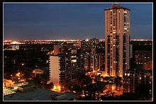
Osborne Village has evolved into a neighborhood filled with character. It is Winnipeg's most densely populated neighbourhood, as well as the second most densely populated neighbourhood in Western Canada.[1] It was voted the Best Place to Live in Uptown Magazine's 2008 Best of List [2]. Popular annual events include the Canada Day Festival. Osborne Village is home to one of Winnipeg's most vibrant collection of stores and restaurants with over 175 businesses calling Osborne Village home.
Osborne Village is a complex urban community with a rich heritage and diverse built forms. It’s appreciated as a desirable location in which to live, work, and play. As such, it continues to experience development interest. Historically and more recently, developments that enhance the village’s valued character have been proposed and these have been embraced by the community. Others, however, have been welcomed less enthusiastically; still others have been hotly contested.[3]
City Firsts
City firsts are many, including first kitchen stores, first outdoor patio, and first artists’ collective gallery.[4]
Arts Scene
Osborne Village is home to many of Winnipeg's emerging and well established artists. The city's first artists' collective makes its home in the Village, as well as many dance studios and venues for bands and musicians of all kinds. In the summer months you can find talented street performers all day long on the street corners playing everything from guitars and drums to violins. For the performing arts Osborne Village is home to a 235-seat rental venue with a licensed bar and patio, and a large end stage and state-of-the-art lighting system.[5]
Canada Day
Osborne Village's annual Canada Day celebration organized by the Osborne Village BIZ (Business Improvement Zone) draws thousands of people from Winnipeg and surrounding areas each year. With a kids zone, hundreds of artisans and vendors and patios extended into the street in front of nearly every bar and restaurant, it is one of the busiest Canada Day celebrations in the west.
References
- ^ City of Winnipeg Osborne Village neighbourhood Plan http://winnipeg.ca/clkdmis/documents/c/2006/a6621/pd%2009%2019%20no.%2015%20att.pdf
- ^ "BEST OF WINNIPEG 2008!". http://www.uptownmag.com/2008-05-15/page2270.aspx.
- ^ City of Winnipeg Osborne Village neighbourhood Plan http://winnipeg.ca/clkdmis/documents/c/2006/a6621/pd%2009%2019%20no.%2015%20att.pdf
- ^ http://where.ca/winnipeg/guide_listing.cfm?listing_id=4041
- ^ http://www.gasstationtheatre.com/Facilities.html
Neighbourhoods in Winnipeg Agassi · Airport · Alpine Place · Amber Trails · Archwood · Armstrong Point · Beaumont · Betsworth · Birchwood · Booth · Broadway–Assiniboine · Brockville · Brooklands · Bruce Park · Buchanan · Burrows–Keewatin · Burrows Central · Canterbury Park · Centennial · Central Park · Central St Boniface · Chalmers · Charleswood · Chinatown · Cloutier Drive · Colony · Crescent Park · Crescentwood · Crestview · Dakota Crossing · Daniel McIntyre · Deer Lodge · Dufferin · Dufresne · Eaglemere · Earl Grey · East Elmwood · East Kildonan · Ebby–Wentworth · Edgeland · Elm Park · Elmhurst · Elmwood · Eric Coy · Exchange District · Fort Richmond · Fort Rouge · Garden City · Glendale · Glenelm · Glenwood · Grant Park · Grassie · Heritage Park · Holden · Inkster–Faraday · Inkster Gardens · Island Lakes · J.B. Mitchell · Jameswood · Jefferson · Kensington · Kern Park · Kil-cona Park · Kildare–Redonda · Kildonan Drive · King Edward · Kingston Crescent · Kirkfield · Lavalee · Leila–McPhillips Triangle · Linden Woods · Logan–CPR · Lord Roberts · Lord Selkirk Park · Luxton · Maginot · Mandalay West · Margaret Park · Marlton · Mathers · Maybank · McMillan · Meadowood · Meadows · Melrose · Minnetonka · Minto · Mission Gardens · Montcalm · Munroe East · Munroe West · Mynarski · Niakwa Park · Niakwa Place · Norberry · Normand Park · North Point Douglas · North St Boniface · Norwood East · Norwood West · Old Tuxedo · Parc La Salle · Peguis · Pembina Strip · Point Road · Portage–Ellice · Pulberry · Radisson · Richmond Lakes · Richmond West · Ridgedale · Ridgewood South · River–Osborne · River East · River Heights · River Park South · River West Park · Riverbend · Rivergrove · Riverview · Robertson · Roblin Park · Rockwood · Roslyn · Rosser–Old Kildonan · Rossmere–A · Rossmere–B · Royalwood · Sargent Park · Seven Oaks · Seven Oaks · Shaughnessy Park · Silver Heights · Sir John Franklin · South Point Douglas · South Portage · South Tuxedo · Southboine · Southdale · Southland Park · Spence · Springfield North · Springfield South · St. George · St. James-Assiniboia · St. John's Park · St. John's · St. Matthews · St. Norbert · St. Vital · Perimeter South · Sturgeon Creek · Talbot–Grey · Templeton–Sinclair · The Maples · Tissot · Transcona South · Trappistes · Tuxedo · Tyndall Park · University · Valhalla · Valley Gardens · Varennes · Varsity View · Vialoux · Victoria Crescent · Victoria West · Vista · Waverley Heights · Wellington Crescent · West Alexander · West Broadway · West Wolseley · Westdale · Weston · Westwood · Whyte Ridge · Wildwood · Wilkes South · William Whyte · Victoria West · Windsor Park · Wolseley · Woodhaven · Worthington
Coordinates: 49°52′43″N 97°08′45″W / 49.87861°N 97.14583°W
Categories:- Neighbourhoods in Winnipeg
Wikimedia Foundation. 2010.


