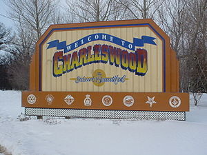
- Charleswood, Winnipeg
-
Charleswood is a residential community within the city of Winnipeg, Manitoba, Canada. It is located in the southwestern part of the city, and is bordered by the Assiniboine River to the north, the Rural Municipality of Macdonald to the south, the Rural Municipality of Headingley on the west and the Assiniboine Park and Forest to the east. Until it joined with the City of Winnipeg in 1972 it was a separate municipality known as the Rural Municipality of Charleswood. The population is 26,440 (Source: Statistics Canada Census 2001).
History
Before European settlement, the region was home to an ancient ford across the Assiniboine River. A ferry service was in operation in the region as late as 1958, and a trail leading to the ford was visible until fairly recently.
Patrick H. Kelly (1847-1940) a Farmer and municipal official moved from Perth County, Ontario in 1906 and settled in the then Rural Municipality of Assiniboia, taking over 500 acres of land in what is now the Charleswood suburb of Winnipeg. He is widely regarded as the founder of Charleswood. He built a general store and was key in establishing Charleswood's first post office. He also persuaded the Winnipeg Electric Railway Company to extend the street railway so that Charleswood had a connection with the city. He also was responsible for persuading residents of the community to apply for the creation of Charleswood as a separate municipality. This was successful and the first four meetings of the new municipal council were held in a room in his store. He also was instrumental in developing the Charleswood school.[1]
There was little housing in Charleswood before 1920 and only limited growth between 1920 and 1946. Following World War II, it became popular with immigrants from Europe who wanted to avoid living too close to the centre of Winnipeg. Development of the area increased, and new houses were constructed in the Roblin Park, Marlton, and Varsity View neighbourhoods. The area experienced particularly strong growth in the 1970s, with at least 7,500 homes built during that decade.
In 1995 the Charleswood Bridge opened over the Assiniboine River connecting Charleswood with the suburb of St. James-Assiniboia. Charleswood is unique among Winnipeg's suburban areas in that it retains a semi-rural atmosphere. Many streets remain unpaved, do not have sidewalks and are lined with ditches.
Charleswood will soon expand south to form Charleswood Part 2.
Sports
Charleswood is home to the Charleswood Hawks hockey team playing out of the MMJHL
Team Founded League Arena Championships Charleswood Hawks 1970 MMJHL Eric Coy Arena 12 Charleswood is also home to the Charleswood Curling Club, home club of 6 time provincial, 2 times national, and 1996 world curling champion Jeff Stoughton.
Neighbourhoods in Winnipeg Agassi · Airport · Alpine Place · Amber Trails · Archwood · Armstrong Point · Beaumont · Betsworth · Birchwood · Booth · Broadway–Assiniboine · Brockville · Brooklands · Bruce Park · Buchanan · Burrows–Keewatin · Burrows Central · Canterbury Park · Centennial · Central Park · Central St Boniface · Chalmers · Charleswood · Chinatown · Cloutier Drive · Colony · Crescent Park · Crescentwood · Crestview · Dakota Crossing · Daniel McIntyre · Deer Lodge · Dufferin · Dufresne · Eaglemere · Earl Grey · East Elmwood · East Kildonan · Ebby–Wentworth · Edgeland · Elm Park · Elmhurst · Elmwood · Eric Coy · Exchange District · Fort Richmond · Fort Rouge · Garden City · Glendale · Glenelm · Glenwood · Grant Park · Grassie · Heritage Park · Holden · Inkster–Faraday · Inkster Gardens · Island Lakes · J.B. Mitchell · Jameswood · Jefferson · Kensington · Kern Park · Kil-cona Park · Kildare–Redonda · Kildonan Drive · King Edward · Kingston Crescent · Kirkfield · Lavalee · Leila–McPhillips Triangle · Linden Woods · Logan–CPR · Lord Roberts · Lord Selkirk Park · Luxton · Maginot · Mandalay West · Margaret Park · Marlton · Mathers · Maybank · McMillan · Meadowood · Meadows · Melrose · Minnetonka · Minto · Mission Gardens · Montcalm · Munroe East · Munroe West · Mynarski · Niakwa Park · Niakwa Place · Norberry · Normand Park · North Point Douglas · North St Boniface · Norwood East · Norwood West · Old Tuxedo · Parc La Salle · Peguis · Pembina Strip · Point Road · Portage–Ellice · Pulberry · Radisson · Richmond Lakes · Richmond West · Ridgedale · Ridgewood South · River–Osborne · River East · River Heights · River Park South · River West Park · Riverbend · Rivergrove · Riverview · Robertson · Roblin Park · Rockwood · Roslyn · Rosser–Old Kildonan · Rossmere–A · Rossmere–B · Royalwood · Sargent Park · Seven Oaks · Seven Oaks · Shaughnessy Park · Silver Heights · Sir John Franklin · South Point Douglas · South Portage · South Tuxedo · Southboine · Southdale · Southland Park · Spence · Springfield North · Springfield South · St. George · St. James-Assiniboia · St. John's Park · St. John's · St. Matthews · St. Norbert · St. Vital · Perimeter South · Sturgeon Creek · Talbot–Grey · Templeton–Sinclair · The Maples · Tissot · Transcona South · Trappistes · Tuxedo · Tyndall Park · University · Valhalla · Valley Gardens · Varennes · Varsity View · Vialoux · Victoria Crescent · Victoria West · Vista · Waverley Heights · Wellington Crescent · West Alexander · West Broadway · West Wolseley · Westdale · Weston · Westwood · Whyte Ridge · Wildwood · Wilkes South · William Whyte · Victoria West · Windsor Park · Wolseley · Woodhaven · Worthington
Coordinates: 49°51′09″N 97°17′03″W / 49.8525°N 97.28417°W
References
- ^ "Patrick H. Kelly (1847-1940)" Memorable Manitobans <http://www.mhs.mb.ca/docs/people/kelly_p.shtml>
Categories:- Neighbourhoods in Winnipeg
Wikimedia Foundation. 2010.

