- Clearwater River (Alberta)
-
For other rivers called Clearwater, see Clearwater River (disambiguation).
Clearwater is a river of southern Alberta, Canada. Situated entirely in the Canadian Rockies and the Rocky Mountain foothills of Alberta, it is a glacier fed upper reach tributary of the North Saskatchewan River. The upper reach of the Clearwater has become popular for equestrian travelers due to the natural setting along the river.
Contents
Course
When measuring from Trident Lake, the Clearwater River has a length of 203 kilometers and descends 350 m to its end at Rocky Mountain House.
- The river begins in Banff National Park on the southern slope of Mount Wellington immediately into the Devon Lakes at Clearwater Pass.
- From the Devon Lakes it flows 11 km and descends 400 m to Clearwater Lake.
- 2 km after Clearwater Lake and 50 m down the river hits Trident Lake where it becomes navigable by canoe.
- After traveling 15 km west and descending 120 m the river exits Banff National Park.
- The river travels 18 more kilometers west and descends 150 m before turning north and exiting the Ram Range in the Rocky Mountain Foothills.
- About 20 kilometers the rivers turns west again and meets its first road around Idlewild Mountain.
- About 70 kilometers and the rivers turns north west.
- About 30 more kilometers and the river empties into the North Saskatchewan River.
Tributaries
- Martin Creek
- Roaring Creek
- Malloch Creek
- Peters Creek
- Forbidden Creek
- Timber Creek
- Washout Creek
- Peppers Creek
- Elk Creek
- Idlewild Creek
- Cuttoff Creek
- Rock Creek
- Limestone Creek
- Seven Mile Creek
- Pineneedle Creek
- Tay River
- Alford Creek
- Prairie Creek
Photo gallery
-
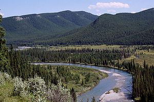
Clearwater River in the Canadian Rockies
References
- Wild Rivers. Alberta., by Canada. Wild Rivers Survey.
External links
- Alcazar Mountain: Clearwater River Hike 2006 - A journal log with photos describing a hike along the Clearwater River.
Hydrography of Alberta Rivers Waterfalls Lakes Reservoirs Glaciers Other - Peace–Athabasca Delta
Coordinates: 52°21′43″N 114°56′52″W / 52.36194°N 114.94778°W
Categories:- Rivers of Alberta
Wikimedia Foundation. 2010.


