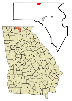
- McCaysville, Georgia
-
McCaysville, Georgia — City — Location in Fannin County and the state of Georgia Coordinates: 34°58′54″N 84°22′13″W / 34.98167°N 84.37028°WCoordinates: 34°58′54″N 84°22′13″W / 34.98167°N 84.37028°W Country United States State Georgia County Fannin Area - Total 1.7 sq mi (4.2 km2) - Land 1.6 sq mi (4.1 km2) - Water 0.1 sq mi (0.1 km2) Elevation 1,463 ft (446 m) Population (2000) - Total 1,071 - Density 630/sq mi (255/km2) Time zone Eastern (EST) (UTC-5) - Summer (DST) EDT (UTC-4) ZIP code 30555 Area code(s) 706 FIPS code 13-48428[1] GNIS feature ID 0328732[2] McCaysville is a city in Fannin County, Georgia, United States. The population was 1,071 at the 2000 census.
Contents
Geography
McCaysville is located at 34°58′54″N 84°22′13″W / 34.98167°N 84.37028°W (34.981534, -84.370293)[3]. According to the United States Census Bureau, the city has a total area of 1.6 square miles (4.1 km2), of which, 1.6 square miles (4.1 km2) of it is land and 0.1 square miles (0.26 km2) of it (3.07%) is water.
McCaysville is along the border between northwest Georgia and southeast Tennessee, along with its twin city of Copperhill, Tennessee. The two are situated as a single town along a river, known as the Toccoa River in Georgia, and the Ocoee River in Tennessee. The change occurs in the middle of town at the state line, which runs diagonally relative to the street grid, which is aligned with the river rather than the border. The boundary also means that the McCaysville side is in area code 706, while the Copperhill side is in area code 423. The main street through town is Georgia 5 and Tennessee 68.
In 1990, a massive flood struck the towns in the dark morning hours of February 16.
Climate
McCaysville's weather is temperate due to its elevation and location in the southern Appalachians. Summers are warm with average highs in the middle 80s and lows in the lower 60s. Winters are cool with average highs in the 40s and average lows in the 20s. Rainfall is abundant with the yearly average approaching 67 inches and occurring on 127 days. Snowfall usually occurs on several occasions during the winter months and can range from a light dusting to the occasional significant storm. The most significant snow storm to hit the area occurred March 12–14, 1993 when the area received approxmiately 40 inches in what eastern seaboard residents often refer to as "the storm of the century". The average first frost occurs in mid-October with the average last frost occurring in late April.
Demographics
As of the census[1] of 2000, there were 1,071 people, 540 households, and 324 families residing in the city. The population density was 680.8 people per square mile (263.4/km²). There were 604 housing units at an average density of 383.9 per square mile (148.5/km²). The racial makeup of the city was 97.11% White, 0.19% African American, 0.65% Native American, 0.19% Asian, 0.93% from other races, and 0.93% from two or more races. Hispanic or Latino of any race were 1.40% of the population.
There were 540 households out of which 20.7% had children under the age of 18 living with them, 40.9% were married couples living together, 14.8% had a female householder with no husband present, and 40.0% were non-families. 38.3% of all households were made up of individuals and 23.9% had someone living alone who was 65 years of age or older. The average household size was 1.98 and the average family size was 2.57.
In the city the population was spread out with 17.9% under the age of 18, 6.3% from 18 to 24, 20.6% from 25 to 44, 26.3% from 45 to 64, and 28.8% who were 65 years of age or older. The median age was 48 years. For every 100 females there were 77.6 males. For every 100 females age 18 and over, there were 73.7 males.
The median income for a household in the city was $18,583, and the median income for a family was $30,078. Males had a median income of $27,045 versus $20,185 for females. The per capita income for the city was $12,904. About 14.0% of families and 23.2% of the population were below the poverty line, including 23.7% of those under age 18 and 24.8% of those age 65 or over.
Notable natives
- Joe Tipton - Major League Baseball catcher born here
References
- ^ a b "American FactFinder". United States Census Bureau. http://factfinder.census.gov. Retrieved 2008-01-31.
- ^ "US Board on Geographic Names". United States Geological Survey. 2007-10-25. http://geonames.usgs.gov. Retrieved 2008-01-31.
- ^ "US Gazetteer files: 2010, 2000, and 1990". United States Census Bureau. 2011-02-12. http://www.census.gov/geo/www/gazetteer/gazette.html. Retrieved 2011-04-23.
External links
Municipalities and communities of Fannin County, Georgia Cities Blue Ridge | McCaysville
Town Categories:- Cities in Georgia (U.S. state)
- Populated places in Fannin County, Georgia
Wikimedia Foundation. 2010.


