- Georgia State Route 5
Infobox road
state=GA
type=
route=5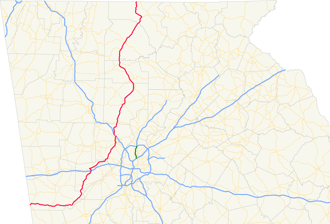
length_mi=167
length_ref= [http://www.dot.state.ga.us/DOT/plan-prog/transportation_data/400reports/2002/dpp444_2002.pdf]
length_round=0
established=
direction_a=South
direction_b=North
starting_terminus=
junction= in Carroll Countyin Ropeville
in Whitesburg
in McWhorter
in Douglasville
in Marietta
in Marietta
ending_terminus=
previous_route=4
next_route=6State Route 5 is a route that bisects northern Georgia. It passes through the
county seat s of Blue Ridge, Ellijay, Jasper, Canton, Marietta, and Douglasville. Along the way, it overlaps one of metro Atlanta's freeways,I-575 . From the Cherokee/Pickens County line to Blue Ridge, Georgia 5 is cosigned with State Route 515. It also shares routing withU.S. 76 from Ellijay to Blue Ridge. This route parallels the Marietta and North Georgia Rail Line.Routing
S.R. 5 begins at its northern terminus at the
Tennessee border in the bordertown of McCaysville. It then winds its way through the north Georgia mountains and the above-mentioned cities. After passing through Marietta, it then takes an odd routing as it decreases in importance as a route. Concurrent withU.S. 78 , it goes through downtown Douglasville. After leaving Douglasville, S.R. 5 becomes a strictly rural route before ending, insignificantly, in Carroll County at theAlabama -Georgia line.2007 Rerouting Through Marietta
In October 2007, S.R. 5 was rerouted through Marietta. Prior to the rerouting, the road went south from the split with I-75 through downtown Marietta, and joined the S.R. 120 Loop southward. Currently, the road exits I-75 onto a ramp for U.S. 41, and joins U.S. 41 going south for a few miles, then going west on S.R. 120 Alternate until the road becomes east bound S.R. 120), following the same routing of the old S.R. 120 Loop, which was decomissioned at the same time.
"Old Highway 5"
From the late 1970s to the early 1990s, Interstate 575 and Georgia Highway 515 were constructed. S.R. 5 between Canton and Marietta had become a congested and dangerous route. This new freeway would alleviate these problems. Upon completion, the signage for S.R. 5 was removed from the state roads it signified and placed alongside the I-575 and S.R. 515 shields; thus creating "Old Highway 5". Throughout the 1990s, parts of Old S.R. 5 from Sixes Road at I-575 in Toonigh to State Route 5 Spur in Marietta were assigned the inventory route number State Route 754 to complete state projects planned for the route before it was completely turned back. However, at that point the entire route was already maintained by the respective counties.
The southern terminus of this route is just north of the Marietta square where Cherokee Street joins Canton Road. However, because of The
Zell Miller Mountain Parkway (S.R. 515) that begins at I-575's northern terminus, Old S.R. 5 stretches all the way to northern Ellijay, creating a continuous stretch of former routing over 60 miles long. North of that point, the new four-lane was built along the existing road and older routings are in pieces north of there including parts in Whitepath, Cherry Log and Blue Ridge.Bannered routes
State Route 5 over its history has contained a tremendous number of bannered routes. The current and notable former ones are as follows:
* State Route 5 Connector - KennesawFollows part of Barrett Parkway from U.S. 41/S.R. 3 to I-575/S.R. 5/S.R. 417.
* State Route 5 Connector - CantonEstablished in 1999 along a new connector road from S.R. 140 to "S.R. 5 Business". This short route was originally slated to be a new location of S.R. 140.
* State Route 5 Spur - MariettaEstablished in 1987 on a limited-access connection to Old S.R. 5 (Canton Road) on what had been "S.R. 5 Connector" prior to the relocation of mainline S.R. 5 to I-575 in 1985.
* State Route 5 Alternate - Jasper and EllijayTwo sections of Old S.R. 5 were retained as S.R. 5 Alt. in Jasper and Ellijay while the new route was under construction. The Jasper portion was first created in 1981, extended in 1984 and deleted in early 1986. The Ellijay portion was first created in 1984 and deleted when work was completed on the new route in 1986.
* State Route 5 Business - Canton"S.R. 5 Business" was established in 1986 along the former S.R. 5 when S.R. 5 was relocated to I-575. The route extends actually west and north of the downtown of Canton, but is the major commercial strip for the city. All but two miles of the highway are actually parts of S.R. 20 and S.R. 140.
* State Route 5 Business - Ball Ground "S.R. 5 Business" in Ball Ground is mostly S.R. 372, but resulted in one mile of new route in 1989 to make a full business route for the city, though it actually runs west of downtown. The highway follows the former S.R. 5 and part of the old Jasper By-Pass.
* State Route 5 Business - Blue Ridge"S.R. 5 Business" in Blue Ridge maintained Old S.R. 5 through Blue Ridge as a state highway, but was deleted in 1989 along with its overlapping route, U.S. 76 Business.Sources: [http://psr.southeastroads.com/| Peach State Roads] (parts of this article written by webmaster of linked site)
Wikimedia Foundation. 2010.