- Georgia State Route 12
-
"GA 12" redirects here. For the congressional district, see Georgia's 12th congressional district.
State Route 12
Route information Maintained by GDOT Major junctions West end: 
 US 278 / SR 10 in Avondale Estates
East end: 
 US 78/US 278/SR 10/SR 17 Bypass at Thomson
Highway system Georgia State Routes
Former SR←  SR 11
SR 11SR 13  →
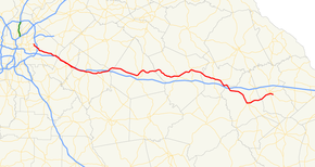
→State Route 12 begins in Avondale Estates, DeKalb County, Georgia at its intersection with SR 10 and ends at SR 10/US 78 in Thomson, Georgia. State Route 12 overlaps U.S. Route 278 its entire length. It is also concurrent with Interstate 20/SR 402 from Exit 75, which is SR 124 (Turner Hill Road) in Lithonia until it reaches Exit 90 in Covington in Newton County. State Route 12 largely runs parallel to Interstate 20 from DeKalb County, near Atlanta, to McDuffie County.
Categories:- State highways in Georgia (U.S. state)


Wikimedia Foundation. 2010.