- Cincinnati Subway
-
Cincinnati Subway 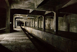
Info Owner SORTA Locale Cincinnati, Ohio Transit type Rapid transit Number of lines 1 Number of stations 4 Operation Began operation Never Technical Track gauge Broad gauge The Cincinnati Subway is a set of unused tunnels and stations for a rapid transit system beneath the streets of Cincinnati, Ohio. It is recognized as the largest abandoned subway tunnel in the United States.[1] Construction took place in the early twentieth century, but the project was not completed so it never hosted a paying customer.[2]
The project has been described as "one of the city's biggest embarrassments,"[3] and "one of Cincinnati's biggest failures."[2] Some argue that because rapid transit was never completed Cincinnati is smaller, forces its citizens to be automobile-dependent, has its downtown area dominated by highways and parking lots, lacks "walkable communities," motivates people to live outside of the city, and has spawned today's traffic jams.[4] Others say it would have been abandoned anyway due to waning ridership, as was the case with the city's original streetcars and the Mount Adams Incline.[2] Others have pointed to the project being a rare example of a city avoiding the sunk cost fallacy.[5]
Proposals to complete the subway have been near continuous since its initial failure, but all attempts to use the tunnels for transit have failed thus far. Many Cincinnatians do not know subway tunnels exist under their city.[6]
Contents
History
Rapid transit was seen as the solution for downtown congestion during the first quarter of the 20th century. Six million dollars were allocated for the project, but construction was delayed due to World War I. Unexpected post-war inflation doubled the cost of construction, so the project could not be finished at the original estimated price. Despite various attempts to use the subway tunnels for mass transit, thus far all attempts have been unsuccessful. Political squabbling, The Great Depression, World War II, and the rise in popularity of the automobile have all contributed to the current failure of the subway.[4]
The idea
 Former location of the Miami and Erie Canal in downtown Cincinnati.
From 1825 until 1920 the Miami and Erie Canal divided Cincinnati's residential neighborhood of Over-the-Rhine from the business district of downtown.[7][8] The canal was used to transport goods and people from the Great Lakes to the Ohio River and subsequently the Mississippi River via Cincinnati, until the popularity of railroads caused it to go into disuse.[7] The canal became unprofitable by 1856[7] and was officially abandoned by the city in 1877.[4] On September 27, 1884 a weekly Cincinnati magazine called The Graphic proposed that the "dead old ditch" be used to provide an unobstructed route for a subway system, with a large boulevard above.[9]
In 1888, Cincinnati began adopting electric streetcars,[9] which soon became the main form of public transportation.[10] By the turn of the 20th century Cincinnati was one of the ten largest cities in the United States,[7] and had a rate of growth and economic importance that was similar to that of New York City and Chicago.[4] The slow streetcars shared the crowded streets with horse-drawn carriages, people, and collided with the first automobiles on an almost daily basis.[10] It was not unusual for trips between downtown and the surrounding suburbs to take 45 minutes or an hour.[11] Despite having 222 miles (357 km) of streetcar tracks, the city found itself in a growing traffic nightmare.[10] In 1910, Henry Thomas Hunt spearheaded plans for a new rapid transit system.[12]
Planning
The next year City Council convinced the Ohio State Legislature to lease the city's portion of the canal for use as a boulevard and subway system.[12] The city hired experts that worked on Boston's and Chicago's Rapid Transit systems to research the best possible implementation for Cincinnati's Rapid Transit system.[13] The result were four "Schemes," or proposed routes. The chosen plan, Scheme IV, modification H, looped around the city hitting the central suburbs of St. Bernard and Norwood, the eastern suburbs of Oakley and Hyde Park, and then returned into downtown.[13]
In 1916 City Council authorized a bond issue of $6,000,000 with an interest rate of 4.25 percent,[14] and then sent Rapid Transit to the public polls.[8] On April 17, 1917, Cincinnati citizens voted in favor of using the bond for a Rapid Transit system, 30,165-14,286.[8] However, just 11 days earlier, the United States entered World War I,[4] so construction was halted because no capital issues of bonds were permitted during the war.[8][15]
War conditions have prompted the opinion in certain official quarters that it would be unwise to proceed with the construction of the loop until after the war. High costs of materials and the difficulty in obtaining deliveries are cited as arguments in favor of the temporary abandonment of the project.—Cincinnati Enquirer, "Subway Again May Meet Delay: Postponement Of Plans Until After War Is Considered," April 5, 1918 (p. 9)Construction and failure
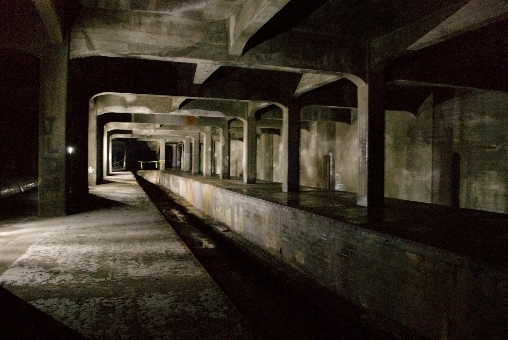
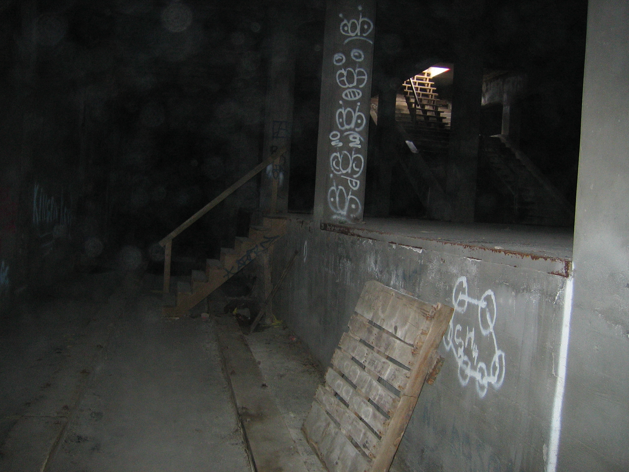
 A station platform and unlaid tracks.
When the war concluded in 1919 the cost of construction had doubled,[16] increasing the original price to complete the loop to $12,000,000 or $13,000,000.[8] Regardless, the city began work on January 28, 1920,[17] and planned to raise the money to complete the loop later. When bonds ran out in 1927 construction ended with seven miles (11 km) of subway dug or graded, but no track had been laid.
New estimates to complete the loop ranged from an additional $6,000,000 to $12,000,000.[4] The boulevard that ran on top of the subway, called "Central Parkway," officially opened to traffic on October 1, 1928, and was followed by a week of public celebration.[18]
Once it became apparent that the original Rapid Transit plan had failed, political squabbling in City Hall stalled any new progress,[4][19] and any hope of raising the money to complete the subway was further delayed with the stock market crash of 1929.[20] Though few citizens owned automobiles when Mayor Hunt first planned Rapid Transit in 1910, their increasing popularity and convenience helped fuel critics' arguments against a subway system. They began referring to the project as "Cincinnati's White Elephant."[16][20]
Attempts at revival
In 1936 the city commissioned the Engineers' Club of Cincinnati to produce a report on how to use the unfinished rapid transit property.[21] The report could not find any use for the tunnels other than what they were originally designed for. Because the city's needs had changed from twenty years earlier the report suggested that the subway "should be forgotten."[21]
However, in 1939 the tunnels were researched for possible automobile traffic, but were found to be unsuitable for that use.[21] In 1940 the city sought the advice of several experts to settle once and for all the fate of the subway. The report recommended placing all streetcar and trolley transportation underground (i.e. a subway), but Cincinnati already had too many other expensive public projects underway.[21][22] The plan was put on hold yet again when the United States entered World War II in 1941.
During World War II, the city was focused on war-time rationing, so completing the subway was not a high priority.[23] The tunnels were suggested as possible air raid shelters, but the idea was never implemented.[23] The tunnels were also suggested for underground storage of commercial and military supplies, then as a pathway to bring freight into the heart of the city, but both ideas were shot down because they'd delay bringing mass transit to Cincinnati.[23] After the war ended the City Planning Commission decided to not include the subway in its plans. Instead, the Commission would use the loop's right-of-way as pathways for Interstate 75 and the Norwood Lateral.[22][24]
In the 1950s a massive 52-inch [25] water main was laid in the north-bound tunnel to save $300,000[26] in construction costs.[1] According to the engineering firm Parsons Brinckerhoff, a redundant water main was installed during the construction of Fort Washington Way so the water main in the subway could easily be removed.[3] There is also an escape clause in Ordinance No. 154-1956 that states, "in the event said section of the rapid transit subway is, at some future date, needed for rapid transit purposes, the Water Works shall remove said main at its sole cost."[26]
The subway bonds were finally paid off in 1966 at a total price of $13,019,982.45.[4] Around that time Meier's Wine Cellars Inc. wanted to use the subway tunnels to store wine, as well as install a bottling operation to draw tourists, but it fell through due to a lack of proper building codes.[27] In the 1970s Nick Clooney wanted to turn parts of the tunnel into an underground mall, as well as a night club, but that fell through early on due to insurance issues.[2][27] In the 1980s the city pitched the tunnels to Hollywood filmmakers as an ideal location to shoot subway scenes.[27] In particular, the location was presented to the makers of Batman Forever, but as of 2008 the tunnels have not been used in any feature films.[27]
In 2002 the subway tunnels were proposed as a route for a regional light rail system that would cost $2.6 billion and take thirty years to build.[3] The tunnels were favored because they were in an ideal location, they could easily be used to connect the east side and the west sides of Cincinnati, and they would've saved the city at least $100,000,000 in construction costs at the time.[3] The light rail plan, called MetroMoves, proposed a tax levy that would've raised sales tax in Hamilton county by a half-cent.[28] The plan was voted down by more than a 2-to-1 ratio.[28]
Recently, the uncompleted subway tunnels and stations have been described as "strikingly well preserved"[1] and "in good shape."[3] This is partially credited to the original construction quality,[2] and partially because Cincinnati must use tax dollars to maintain the tunnel because Central Parkway is situated on top of it.[3][25]
As of 2008 it would cost $2.6 million over five years to maintain the tunnels as they currently are, $19 million to fill the tunnels with dirt, and $100.5 million to revive the tunnels for modern subway use. Relocating the 52-inch (1.3 m) water main would cost $14 million.[25]
Stations and route
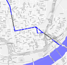
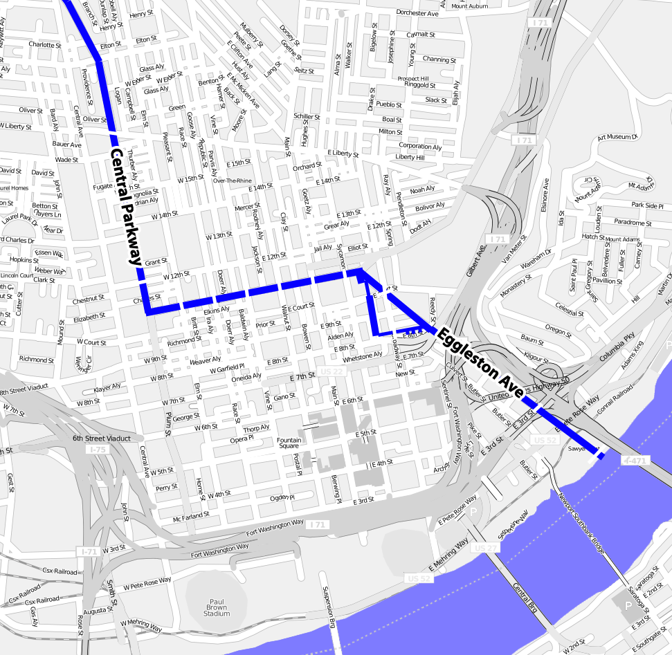
Seven stations were completed along Central Parkway. Underground locations are at Race Street, Liberty Street, Linn Street, and Brighton Place. Above-ground locations were at Marshall Street, Ludlow Avenue, and Clifton Avenue. The underground stations remain intact, but the above-ground stations were demolished when I-75 was built in the 1960s.
The first station was the Race Street Station, which was to serve as the main hub. It was configured with the platform in the center, with the subway running along the north and south side. Next was Liberty Street, which was a through-station. It was a simple design with a platform on each side of the track. Third was Linn Street, a through station. Laid out similarly to Liberty Street, this station has been sealed up, and can be easily missed when walking through. Fourth was Brighton Place, another through-station. Marshall Street was the most grand of the above-ground stations, located to the west near the Mill Creek Valley. Ludlow Avenue Station was constructed under the south side of the Ludlow Viaduct and was also a through-station. The last to be completed was Clifton Avenue, which was located where the street passes under present day I-75. There were additional stations in the plan; however, funding ran out as the project reached Norwood. [29]
Engineering
The subway tunnels run north and south. Each of the two halves of the tube has a minimum width of 13 feet (4.0 m) and a height of 15 feet 6 inches (4.72 m). This should be ample room to accommodate any type of street car, trolley coach, or bus. Each tunnel has parallel wooden stringers which are bolted to the floor, and are intended to support steel rails that were never laid. They are 59 inches (1.5 m) from center to center, which is 6 inches (150 mm) wider than most railway lines. All curves in the tunnel are gradual, and on those curves the outside stringer was raised higher than the inner stringer to accommodate trains traveling at speeds of more than 40 miles per hour (64 km/h). [30]
There were many details of the unfinished subway system, such as a provision for a station at Mohawk Corner, where the wall has been set back. At Walnut Street the lines begin to curve south to go into downtown, but they are stopped short by a bricked up wall. The subway tube is double tracked throughout its entire length, with a concrete wall separating the two tracks. Openings in the wall enable persons to step from one track to another. The tunnels are well ventilated and provide much light until Liberty Street is reached.[30]
Tours
Twice a year, citizens have the opportunity to explore the historic subway.
- Cincinnati Museum Center Tours are available through their Heritage Programs. The two-hour "Talk & Walk Tour" provides adventure and information beginning with a presentation about the history of the subway and continuing with a five-block walk underground. On May 1, 2010, 5 groups of 50 people each toured the subway.
- Over-The-Rhine Foundation has been known to host subway tours during Bockfest, in March.
Both subway tours begin at Media Bridges, located at Race Street and Central Parkway, downtown. Space is limited and tickets sell out quickly.
Similar subways
Cincinnati's design was very similar to Boston's Cambridge-Dorchester Tunnel (Red Line). A similar construction can also be found at the Newark City Subway using the former bed of the Morris Canal, the similarly abandoned Rochester Subway, which used the bed of the Erie Canal, as well as Calgary's not yet used C-Train tunnels, underneath 8th Ave on Downtown Calgary, Alberta, Canada
See also
Notes
- ^ a b c "Cincinnati's Subway" (video). YouTube. February 4, 2008. http://www.youtube.com/watch?v=zY0qSNmS_Fo. Retrieved 2008-05-12.
- ^ a b c d e Krewedl, Derek. (October 22, 2002) "New life for old subway?", Downtowner. pp.1,14.
- ^ a b c d e f Pilcher, James (July 29, 2002). "Abandoned subway could save light rail plan". Cincinnati Enquirer. http://www.enquirer.com/editions/2002/07/29/loc_abandoned_subway.html. Retrieved 2008-07-03.
- ^ a b c d e f g h Radel, Cliff (May 24, 2003). "Life under the city: Subway legend has never left the station". Cincinnati Enquirer. pp. 12–27. http://www.enquirer.com/editions/2003/05/24/loc_radel24.html. Retrieved 2008-06-08.
- ^ https://www.mckinseyquarterly.com/Learning_to_let_go_Making_better_exit_decisions_1768
- ^ "City of Cincinnati — The Cincinnati Subway". http://www.cincinnati-oh.gov/transeng/pages/-7185-/. Retrieved 2008-12-07.
- ^ a b c d Singer 2003, p.17.
- ^ a b c d e Body in Charge of Transit System (April 3, 1926). "Progress of Work Reviewed". Cincinnati Enquirer: pp. 14–15
- ^ a b Singer 2003, p.18.
- ^ a b c Singer 2003, p.19.
- ^ Singer 2003, p.46
- ^ a b Singer 2003, p.35.
- ^ a b Singer 2003, p.36.
- ^ "... Bonds To Pay 4 1/4% Interest". Cincinnati Post: p. 12. June 17, 1916
- ^ Singer 2003, p.45
- ^ a b Singer 2003, p.71.
- ^ "The Cincinnati Subway System". Ohio Exploration. http://www.forgottenoh.com/subway.html. Retrieved January 28, 2010.
- ^ Singer 2003, p.47.
- ^ Singer 2003, p.73.
- ^ a b Singer 2003, p.81.
- ^ a b c d Singer 2003, p.82.
- ^ a b Singer 2003, p.98.
- ^ a b c Singer 2003, p.92.
- ^ Singer 2003, p.103.
- ^ a b c "Cincinnati Considers Options For Decades-Old Unfinished Subway". http://www.wlwt.com/news/14790068/detail.html. Retrieved 2008-05-12.
- ^ a b Singer 2003, p.102.
- ^ a b c d Singer 2003, p.110.
- ^ a b Pilcher, James (November 6, 2002). "Metro plan hits wall of resistance". Cincinnati Enquirer. http://www.enquirer.com/editions/2002/11/06/loc_literail06.html. Retrieved 2008-07-03.
- ^ Cincinnati's Abandoned Subway, (2010). Pro. Paige E. Malott. Dir. Leland Schuler. DVD. Time Bonus Productions, LLC, Cincinnati, OH.
- ^ a b Stimson, George P. (April 24, 1936). "Unused Subway System is in Almost Perfect Condition". Cincinnati Times Star: p. 2
References
- Cincinnati's Abandoned Subway, (2010). Pro. Paige E. Malott. Dir. Leland Schuler. DVD. Time Bonus Productions, LLC, Cincinnati, OH. A documentary film about the history, failure, and present condition of the subway. Features commentary from local historians and city engineers, as well as original construction photographs from the 1920s.
- Singer, Allen J. (May 26, 2003). The Cincinnati subway: history of rapid transit. Images of America Series. Mount Pleasant, SC: Arcadia Publishing. ISBN 9780738523149. http://books.google.com/books?id=Y7F8zr3DwTsC. Retrieved July 23, 2011.
External links
- Queen City Discovery: Subway 2010 Current photographs of the stations.
- The Cincinnati Subway Additional current photographs of the stations.
- Images of Cincinnati Subway Construction
- Metro|Cincinnati A 2010 vision for rapid transit in the Greater Cincinnati and Northern Kentucky region.
- Cincinnati Subway Revival Study A 2008 study by URS Corporation shows that light rail could be implemented in the original tunnels.
- A much more detailed account of the Cincinnati Subway story.
- UrbanAdventure.org's tour of the subway in 2002.
- Forgotten Ohio - Cincinnati Subway
- City of Cincinnati - The Cincinnati Subway
Categories:- Rapid transit in Ohio
- Transportation in Cincinnati, Ohio
- Underground rapid transit in the United States
- Abandoned rapid transit stations
- Cancelled subways

Wikimedia Foundation. 2010.