- Mountainaire, Arizona
-
Mountainaire, Arizona — CDP — Mountainaire Fire Dept. Location in Coconino County and the state of Arizona
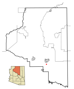
Coordinates: 35°5′28″N 111°39′37″W / 35.09111°N 111.66028°WCoordinates: 35°5′28″N 111°39′37″W / 35.09111°N 111.66028°W Country United States State Arizona County Coconino Area – Total 10.2 sq mi (26.4 km2) – Land 10.2 sq mi (26.5 km2) – Water 0.0 sq mi (0.0 km2) Elevation 6,800 ft (2,073 m) Population (2000) – Total 1,014 – Density 99.2/sq mi (38.3/km2) Time zone MST (UTC-7) ZIP code 86001 Area code 928 FIPS code 04-47820 GNIS feature ID 0032083 Mountainaire is a census-designated place (CDP) in Coconino County, Arizona, United States. The population was 1,014 at the 2000 census.
Contents
Geography
Mountainaire is located at 35°5′28″N 111°39′37″W / 35.09111°N 111.66028°W (35.091096, -111.660193).[1]
According to the United States Census Bureau, the CDP has a total area of 10.2 square miles (26.5 km²), all of it land.
Mountainaire CDP includes Kachina Hills and Mountainaire subdivisions, and nearby areas [2]
Demographics
As of the census[3] of 2000, there were 1,014 people, 417 households, and 246 families residing in the CDP. The population density was 99.2 people per square mile (38.3/km²). There were 556 housing units at an average density of 54.4/sq mi (21.0/km²). The racial makeup of the CDP was 86.09% White, 0.30% Black or African American, 7.69% Native American, 0.30% Asian, 0.10% Pacific Islander, 3.06% from other races, and 2.47% from two or more races. 6.61% of the population were Hispanic or Latino of any race.
There were 417 households out of which 31.4% had children under the age of 18 living with them, 46.8% were married couples living together, 8.2% had a female householder with no husband present, and 41.0% were non-families. 26.6% of all households were made up of individuals and 4.1% had someone living alone who was 65 years of age or older. The average household size was 2.43 and the average family size was 3.04.
In the CDP the age distribution of the population shows 24.7% under the age of 18, 8.5% from 18 to 24, 39.6% from 25 to 44, 23.5% from 45 to 64, and 3.7% who were 65 years of age or older. The median age was 33 years. For every 100 females there were 110.4 males. For every 100 females age 18 and over, there were 107.6 males.
The median income for a household in the CDP was $41,250, and the median income for a family was $49,355. Males had a median income of $32,406 versus $27,125 for females. The per capita income for the CDP was $23,625. About 5.3% of families and 7.4% of the population were below the poverty line, including 10.9% of those under age 18 and none of those age 65 or over.
Notes
- ^ "US Gazetteer files: 2010, 2000, and 1990". United States Census Bureau. 2011-02-12. http://www.census.gov/geo/www/gazetteer/gazette.html. Retrieved 2011-04-23.
- ^ Map of Mountainaire CDP
- ^ "American FactFinder". United States Census Bureau. http://factfinder.census.gov. Retrieved 2008-01-31.
External links
Municipalities and communities of Coconino County, Arizona Cities 
Towns CDPs Bitter Springs | Cameron | Doney Park | Grand Canyon Village | Kachina Village | Kaibab‡ | Kaibito | Lechee | Leupp | Moenkopi | Mountainaire | Munds Park | Parks | Supai | Tonalea | Tuba City | Winslow West‡
Unincorporated
communitiesBellemont | Forest Lakes | Gray Mountain | Happy Jack | Hualapai Hilltop | Jacob Lake | Marble Canyon | North Rim | Valle | Winona
Indian reservations Ghost town Footnotes ‡This populated place also has portions in an adjacent county or counties
Categories:- Census-designated places in Coconino County, Arizona


Wikimedia Foundation. 2010.