- Moores Mill, Alabama
-
"Moores Mill" redirects here. For the West Virginia community also known as Moores Mill, see Cottageville, West Virginia.
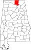
Moores Mill, Alabama — CDP — Location in Madison County and the state of Alabama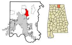
Coordinates: 34°49′50″N 86°31′13″W / 34.83056°N 86.52028°W Country United States State Alabama County Madison Area – Total 13.9 sq mi (35.9 km2) – Land 13.9 sq mi (35.9 km2) – Water 0 sq mi (0 km2) Elevation 689 ft (210 m) Population (2000) – Total 5,178 – Density 372.5/sq mi (144.2/km2) Time zone Central (CST) (UTC-6) – Summer (DST) CDT (UTC-5) FIPS code 01-51216 GNIS feature ID 0156733 Moores Mill is a census-designated place (CDP) in Madison County, Alabama, United States, and is included in the Huntsville-Decatur Combined Statistical Area. The population was 5,178 at the 2000 census.
Geography
Moores Mill is located at 34°49′50″N 86°31′14″W / 34.83056°N 86.52056°W (34.830662, -86.520538)[1].
According to the U.S. Census Bureau, the CDP has a total area of 13.9 square miles (36 km2), all of it land.
Demographics
As of the census[2] of 2000, there were 5,178 people, 1,912 households, and 1,500 families residing in the CDP. The population density was 373.6 people per square mile (144.2/km²). There were 2,030 housing units at an average density of 146.5 per square mile (56.6/km²). The racial makeup of the CDP was 77.62% White, 18.58% Black or African American, 1.31% Native American, 0.79% Asian, 0.02% Pacific Islander, 0.10% from other races, and 1.58% from two or more races. 0.98% of the population were Hispanic or Latino of any race.
There were 1,912 households out of which 38.9% had children under the age of 18 living with them, 66.6% were married couples living together, 8.6% had a female householder with no husband present, and 21.5% were non-families. 18.3% of all households were made up of individuals and 4.1% had someone living alone who was 65 years of age or older. The average household size was 2.71 and the average family size was 3.09.
In the CDP the population was spread out with 27.9% under the age of 18, 7.4% from 18 to 24, 34.7% from 25 to 44, 22.4% from 45 to 64, and 7.6% who were 65 years of age or older. The median age was 35 years. For every 100 females there were 100.7 males. For every 100 females age 18 and over, there were 98.8 males.
The median income for a household in the CDP was $50,292, and the median income for a family was $53,750. Males had a median income of $32,303 versus $25,449 for females. The per capita income for the CDP was $20,158. About 6.9% of families and 9.9% of the population were below the poverty line, including 14.7% of those under age 18 and 13.8% of those age 65 or over.
References
- ^ "US Gazetteer files: 2010, 2000, and 1990". United States Census Bureau. 2011-02-12. http://www.census.gov/geo/www/gazetteer/gazette.html. Retrieved 2011-04-23.
- ^ "American FactFinder". United States Census Bureau. http://factfinder.census.gov. Retrieved 2008-01-31.
Coordinates: 34°49′50″N 86°31′14″W / 34.830662°N 86.520538°W
Municipalities and communities of Madison County, Alabama Cities Huntsville‡ | Madison‡ | New Hope
Towns CDPs Harvest | Hazel Green | Meridianville | Moores Mill | New Market | Redstone Arsenal
Unincorporated
communitiesFootnotes ‡This populated place also has portions in an adjacent county or counties
Communities of the Huntsville-Decatur Area Population over 100,000 Population over 50,000 Population over 20,000 Population over 10,000 Population over 5,000 Population over 2,000 Population over 1,000 Population over 500 Population over 200 Population under 200 Unincorporated areas Belle Mina · Caddo · Danville · Hulaco · Lacey's Spring · Meridianville · Morgan City · Moulton Heights · New Market · Tanner · ToneyCounties Categories:- Populated places in Madison County, Alabama
- Census-designated places in Alabama
- Huntsville–Decatur Combined Statistical Area


Wikimedia Foundation. 2010.