- Mitzpe Ramon
-
Mitzpe Ramon Hebrew transcription(s) - Hebrew מִצְפֵּה רָמוֹן - ISO 259 Miçpe Ramon 
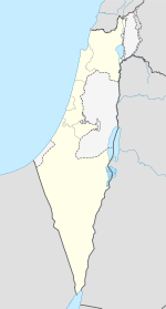
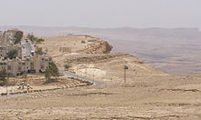
LogoCoordinates: 30°36′29″N 34°48′11″E / 30.608°N 34.803°ECoordinates: 30°36′29″N 34°48′11″E / 30.608°N 34.803°E District South Founded 1951 Government - Type Local council - Head of Municipality Flora Shoshan Area - Total 62,875 dunams (62.9 km2 / 24.3 sq mi) Population (2008) - Total 5,500 Name meaning Ramon Lookout Mitzpe Ramon (Hebrew: מִצְפֵּה רָמוֹן, lit. Ramon Lookout) is a town in the Negev desert of southern Israel. It is situated on the northern ridge at an elevation of 860 meters (2,800 feet) overlooking a sizable erosion cirque known as the Ramon Crater.
Contents
History
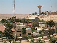
Mitzpe Ramon was founded in 1951 as a camp for the workers building the road to Eilat. The town's first permanent residents, immigrants from North Africa and Romania, settled there in the 1960s, and it became the southernmost of the Negev's development towns. As of 2008, Mitzpe Ramon has a population of 5,500 residents. The mayor is Flora Shoshan, sister of former Israeli defense minister Amir Peretz and wife of the former mayor, Sami Shoshan.[1]
Geology and climate
Ramon Crater, known as a makhtesh, is 38 km long, 6 km wide and 450 meters deep.[2] Mitzpe Ramon experiences hot, dry summers and cold winters. There are moderate to strong winds all year long, caused by its location above the crater, which make Mitzpe Ramon feel much colder than it really is. Snowfall occurs on average once in a couple of years.
Climate data for Mitzpe Ramon (1916-2007) Month Jan Feb Mar Apr May Jun Jul Aug Sep Oct Nov Dec Year Record high °C (°F) 24.4
(75.9)26.4
(79.5)30.4
(86.7)35.6
(96.1)37.2
(99.0)37.6
(99.7)39.7
(103.5)38.2
(100.8)37.8
(100.0)36.2
(97.2)29.6
(85.3)28.2
(82.8)39.2
(102.6)Average high °C (°F) 12.7
(54.9)13.7
(56.7)16.9
(62.4)23.0
(73.4)26.8
(80.2)29.3
(84.7)30.7
(87.3)30.6
(87.1)28.6
(83.5)24.9
(76.8)19.3
(66.7)14.8
(58.6)22.6 Average low °C (°F) 5.9
(42.6)5.9
(42.6)7.7
(45.9)11.8
(53.2)14.7
(58.5)16.8
(62.2)18.4
(65.1)18.5
(65.3)17.2
(63.0)15.2
(59.4)11.4
(52.5)7.8
(46.0)12.6 Record low °C (°F) −2.4
(27.7)−2.2
(28.0)−0.4
(31.3)−0.8
(30.6)6.0
(42.8)10.8
(51.4)13.4
(56.1)14.0
(57.2)11.9
(53.4)9.4
(48.9)2.6
(36.7)1.0
(33.8)−2.4
(27.7)Precipitation mm (inches) 18.9
(0.744)14.7
(0.579)12.0
(0.472)4.9
(0.193)1.3
(0.051)0.0
(0)0.0
(0)0.0
(0)0.1
(0.004)4.6
(0.181)6.5
(0.256)13.7
(0.539)69.5
(2.736)Avg. precipitation days 6.0 4.9 4.1 1.7 0.5 0.0 0.0 0.0 0.1 0.9 2.3 4.6 25.1 Source: Israel Meteorological Service,[3][4] Economy
The development of Mitzpe Ramon was adversely affected by the opening of Route 90 in the late 1960s. After the inauguration of this highway, traffic to and from Eilat bypassed Mitzpe Ramon almost entirely. However, growing interest in ecotourism, Jeep trekking (access to Nabatean ruins), mountain biking and hiking, and the upgrading of Route 40, which is considered a more scenic route to Eilat, have improved the economy.
A hotel opened in Mitzpe Ramon in the late 1990s with an indoor swimming pool. Another hotel with similar accommodations opened in 2011. There is a Visitors Centre overlooking the Ramon Crater and the physically fit can hike down into the crater for a 4 to 5 hour trek without any shade. Among other attractions there is a llama and alpaca farm.
Jerusalem Marble, a major supplier and overseas exporter of Jerusalem stone established in 1923, inaugurated a new, state-of-the-art factory in Mitzpe Ramon in January 2000. [5]
Landmarks
Several large military bases (with over 10,000 soldiers) surround the town, including the large Ramon Airbase. The Wise Astronomy Observatory is located 5 kilometres (3.1 mi) to the west.
References
- ^ Azoulay, Yuval. "Mitzpeh Ramon's Embattled Mayor Pins Hopes on Interior Ministry". Haaretz. http://www.haaretz.com/hasen/spages/918247.html. Retrieved 2008-10-25.
- ^ Makhteshim Country, UNESCO
- ^ "Averages and Records for Mitzpe Ramon (Precipitation, Temperature and Records [Excluding February and May written in the page)"]. Israel Meteorological Service. http://ims.gov.il/IMS/CLIMATE/LongTermInfo.
- ^ "Extremes for Mitzpe Ramon [Records of February and May"]. Israel Meteorological Service. http://www.ims.gov.il/IMS/CLIMATE/TopClimetIsrael.
- ^ Supplying the world with Jerusalem stone
External links
- Mitzpe Ramon travel guide from Wikitravel
- Mitzpe Ramon Local Council (Hebrew)
- Mitzpe Ramon High resolution virtual tours of the crater (English)
South District of Israel Cities 
Local councils Ar'arat an-Naqab · Hura · Kuseife · Lakiya · Lehavim · Meitar · Mitzpe Ramon · Omer · Shaqib al-Salam · Tel as-Sabi · YeruhamRegional councils Abu Basma · Be'er Tuvia · Bnei Shimon · Central Arava · Eshkol · Hevel Eilot · Hof Ashkelon · Lakhish · Merhavim · Ramat HaNegev · Sdot Negev (Azata) · Sha'ar HaNegev · Shafir · Tamar · YoavSee also Other sub-divisions: Center District · Haifa District · Jerusalem District · Judea and Samaria Area · North District · Tel Aviv District Categories:- South District (Israel)
- Local councils in Israel
- Development towns
Wikimedia Foundation. 2010.


