- North European Plain
-
 The North European Plain
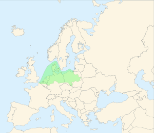
The North European Plain (German: Norddeutsches Tiefland, Polish: Nizina Środkowoeuropejska, i.e. Central European Plain) is a geomorphological region in Europe. It consists of the low plains between the Central European Highlands to the south and the North Sea and the Baltic Sea to the north. These two seas are separated by the Jutland peninsula. The North European Plain is connected to East European Plain, together they form the European Plain.
Contents
Geography
Elevation is between 0 and 200 m (about 0 and 650 ft). While mostly used as farmland, the region also contains bogs, heath, and lakes.
On the North Sea coast, one finds the Wadden Sea, a large tidal area.
On the Baltic Sea coast, one finds the Szczecin Lagoon, the Vistula Lagoon and the Curonian Lagoon, a number of large freshwater lagoons.
Location
North European Plain covers the territories of Belgium, the Netherlands, Germany, Denmark, and Poland; it touches the Czech Republic and southwestern part of Sweden as well. Parts of eastern England can also be considered part of the same plain; as they share its low-lying character and were connected by land to the continent during the last ice age.
Rivers
Major river-drainage basins include, from west to east: the Rhine, Ems, Weser, Elbe, Oder, and Vistula.
Belgium & Netherlands
Historically, especially in the Middle Ages and Early Modern Period, the western section has been known as the Low Countries.
Czech Republic
A tiny southernmost part of the North European Plain called the Silesian Lowlands (formerly Oder Plain) runs in Czech territory in four separated extremities.
Germany
Main article: North German lowlands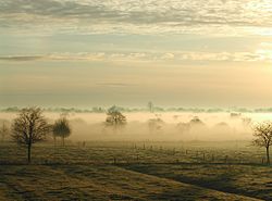
The modern German part of the Northern European Lowlands is also known as the North German Plain. Much of the North German Plain lies less than 100 meters above sea level. On the North Sea coast, the plain is very flat and composed mostly of marshes and mudflats. The offshore East Frisian Islands and North Frisian Islands are considered an extension of the North German Plain that was separated from the mainland after floods during the Middle Ages.
The entire federal-states of Schleswig-Holstein, Hamburg, Bremen, Mecklenburg-Vorpommern, Brandenburg and Berlin, as well as large parts of Lower Saxony, Saxony-Anhalt, Saxony and North Rhine-Westphalia are located in this European geographic region.
Poland
The part in modern day Poland is called the "Polish Plain" (Polish: Niż Polski or Nizina Polska) and stretches from the Baltic Sea in the north to the Sudetes and Carpathians in the south.
England
The extension of the plain into England consists mainly of the flatlands of East Anglia, The Fens and Lincolnshire, where the landscape is in parts strikingly similar to that of the Netherlands.
External links
Categories:- Landforms of Europe
- Plains of Europe
- Geography of Europe
- Physiographic provinces


Wikimedia Foundation. 2010.