- 2007–08 South-West Indian Ocean cyclone season
-
2007–08 South-West Indian Ocean cyclone season 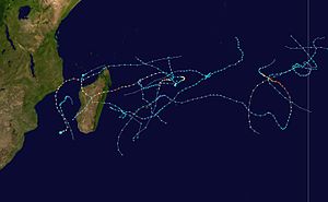
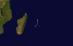
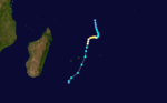
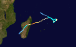
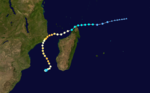
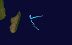
Season summary mapFirst storm formed: October 12, 2007 Last storm dissipated: March 26, 2008 Strongest storm: Hondo – 915 hPa (mbar), 215 km/h (130 mph) (10-minute sustained) Total disturbances: 14 Tropical depressions: 12 Total storms: 12 Tropical cyclones: 6 Total fatalities: 122 Total damage: ~ $38 million (2008 USD) South-West Indian Ocean cyclone seasons
2005–06, 2006–07, 2007–08, 2008–09, 2009–10Related articles: The 2007–08 South-West Indian Ocean cyclone season was an event in the annual cycle of tropical cyclone formation. It began on November 15, 2007, and ended on April 30, 2008, with the exception for Mauritius and the Seychelles, which ended May 15. These dates conventionally delimit the period of each year when most tropical cyclones form in the basin, which is west of 90°E and south of the Equator. Tropical cyclones in this basin are monitored by the Regional Specialised Meteorological Centre in Réunion.
Storms
See also: Timeline of the 2007–08 South-West Indian Ocean cyclone seasonTropical Cyclone 01U
Category 1 tropical cyclone (Australian scale) Tropical storm (SSHS) 

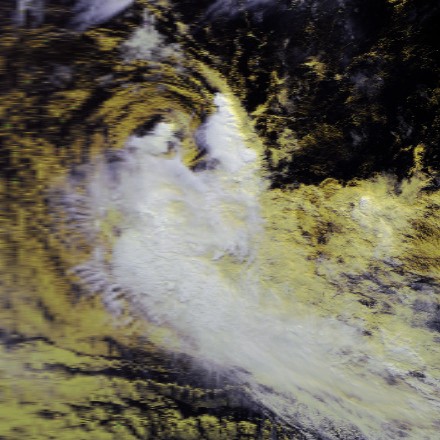
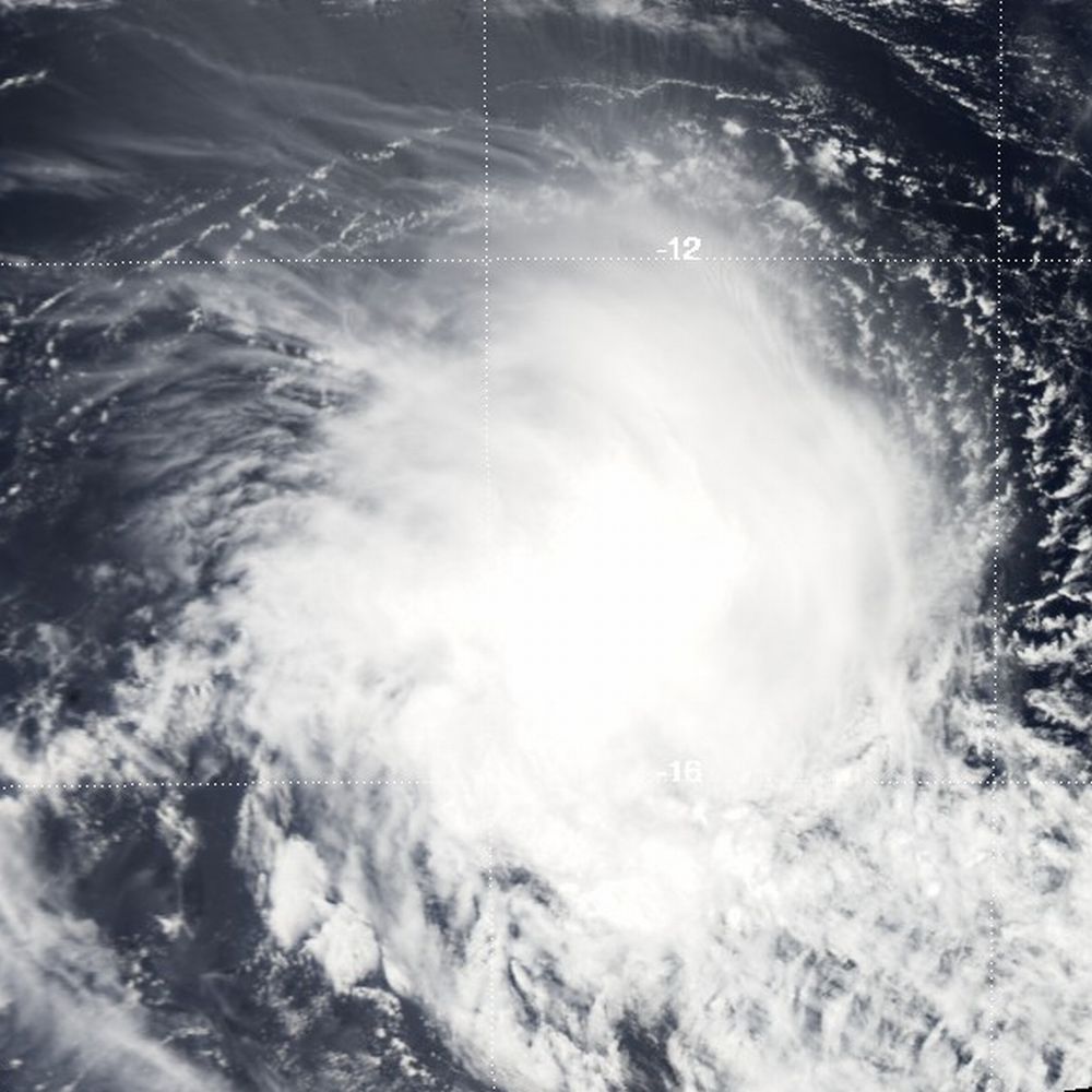
Duration July 26 – July 29 Intensity 75 km/h (45 mph) (10-min), 992 mbar (hPa) On July 26, a tropical disturbance developed within a near-equatorial trough. The next day, convection began to develop around the low while located about 1,500 kilometres (930 mi) east of Diego Garcia. Moderate wind shear temporarily caused the convection to become displaced from the center on July 27. However, later that day, the Joint Typhoon Warning Center (JTWC) assessed the chances of the low developing into a tropical cyclone as "fair".[1] By July 29 the low was designated as Tropical Disturbance 01 while located near the edge of Météo-Frances area of responsibility.[2] With developing banding features, increasing convection and[3] very warm sea-surface temperatures (exceeding 28 °C; 82.4 °F),[4] the JTWC issued a Tropical Cyclone Formation Alert for the low as they assessed the chances of development of a tropical cyclone within 48 hours as "good".[3]
In the post-storm report issued by the Australian Bureau of Meteorology, the system was estimated to have become a Category 1 cyclone, with winds peaking at 75 km/h (45 mph), shortly before leaving Météo-Frances area of responsibility early on July 29.[4] After leaving Météo-Frances area of responsibility, the JTWC designated the storm as Tropical Cyclone 01S.[5] In Météo-Frances post-storm analysis, the disturbance was declassified as a tropical cyclone and the numbering, 01, was removed for unknown reasons.[1]
Tropical Disturbance 01
Tropical disturbance (MFR) 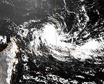

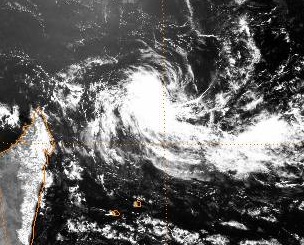
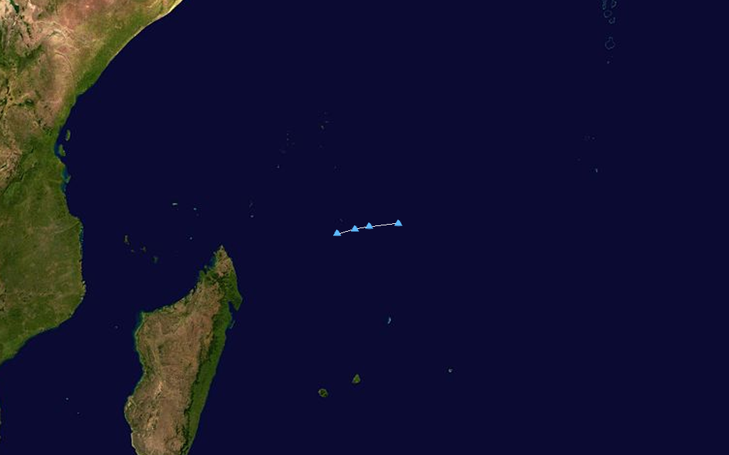
Duration October 12 – October 13 Intensity 45 km/h (30 mph) (10-min), 1005 mbar (hPa) The first officially recognized tropical disturbance developed early on October 10. The disturbance featured persistent convection around an elongated low level circulation located about 600 kilometres (370 mi) west-northwest of Diego Garcia. With marginally favorable. conditions for further development, the JTWC assessed the chances of the low developing into a tropical cyclone as "poor".[6] Further development took place later that day, with banding features developing and deepening convection as it traveled towards the south-southwest. In response to the increased development, the JTWC increased the chances of a tropical cyclone developing to "fair".[7] On October 12 Météo-France designated the system as Tropical Disturbance 01-20072008. However, little or no further development was expected.[8]
Late on October 12 through early on October 13, Dvorak Technique intensity estimates for the low from the JTWC reached T2.5—the equivalent of a minimal tropical storm—and there was a possibility that the system was briefly a tropical storm by one-minute standards.[9] Despite favorable upper-level conditions and low wind shear, the disturbance was situated over cool sea-surface temperatures which provided little energy to fuel convective activity. With little thunderstorm and shower activity development, Météo-France issued their final advisory on the dissipating low the next day. Since the disturbance never impacted land, there were no reports of damage or injuries from it.[9][10]
Severe Tropical Storm Lee-Ariel
Severe tropical storm (MFR) Tropical storm (SSHS) 

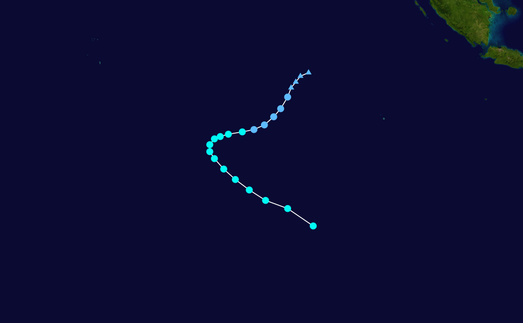
Duration November 15 – November 28 Intensity 95 km/h (60 mph) (10-min), 975 mbar (hPa) On November 13, the Australian Bureau of Meteorology (BoM) began monitoring a tropical low situated about 835 km (519 mi) northwest of the Keeling Islands.[11] The next day, the low was upgraded to a Category 1 cyclone and given the name Lee.[12] Shortly after being named, the JTWC issued a Tropical Cyclone Formation Alert as deep convection persisted around the center of circulation. The system was moving towards the southwest within an area of moderate wind shear.[13] Several hours later, the JTWC designated Lee as Tropical Cyclone 03S.[14] With continued development, Lee strengthened into a Category 2 cyclone, according to the BoM, with winds of 95 km/h (60 mph 10-minute winds).[15] At 1200 UTC, Lee crossed into Météo-France's area of responsibility at peak intensity. Upon entering their AoR, it was given a second name, Ariel, and designated as a severe tropical storm.[16]
Roughly six hours later, the JTWC assessed Lee-Ariel to have reached its peak intensity with winds of 110 km/h (70 mph 1-minute sustained),[17] based on the development of an eye-like structure.[18] The next day, foreword motion slowed significantly due to a subtropical ridge located to the north of the storm. This ridge also caused the storm to turn towards the west, keeping a slow pace.[19] Strong wind shear began to impact the system later that day, causing it to weaken into a moderate tropical storm. Despite the strong shear, most forecast models showed the storm re-intensifying several days out in an area of lower shear.[20] Most of the deep convection was torn away from the system, with little remaining around the center of circulation.[21]
The storm weakened to a tropical depression around 0600 UTC on November 17 as convection continued to dissipate.[22] Despite moving into an area favorable for intensification, Météo-France issued their final advisory on Ex-Lee-Ariel on November 18 as it continued to weaken.[23] The remnants of the system persisted for another ten days, completing an erratic counter-clockwise loop before taking a general westward direction.[24]
Severe Tropical Storm Bongwe
Severe tropical storm (MFR) Category 1 tropical cyclone (SSHS) 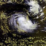
Duration November 17 – November 24 Intensity 100 km/h (65 mph) (10-min), 976 mbar (hPa) An area of disturbed weather developed east of Diego Garcia on November 15. The system slowly organised as it moved southeastward and began interacting with Severe Tropical Storm Ariel, and the Joint Typhoon Warning Center issued a Tropical Cyclone Formation Alert on November 17.[25] The JTWC upgraded the system to Tropical Cyclone 04S early the next day.[26] Also on November 18, RSMC La Reunion classified the system as Tropical Disturbance 03.[27] Later that day, RSMC La Reunion upgraded it to Tropical Depression 03.[28] It was upgraded to Moderate Tropical Storm Bongwe on November 19 and a Severe Tropical Storm later that day.[29][30] Increased wind shear early on November 20 slowed the intensification trend, and weakened it to a moderate tropical storm.[31] However, it restrengthened to a severe tropical storm on November 22.[32] The restrengthening trend was short-lived, however, as the storm weakened once again on November 23,[33] down to a depression and then a disturbance,[34][35] until it finally dissipated on November 24.[36]
Moderate Tropical Storm Celina
Moderate tropical storm (MFR) Tropical storm (SSHS) 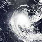

Duration December 11 – December 23 Intensity 75 km/h (45 mph) (10-min), 992 mbar (hPa) An area of disturbed weather developed early on the December 12 north-northeast of Rodrigues.[37] Later that day it was designated as Tropical Disturbance 04R.[38] The Joint Typhoon Warning Center then issued a Tropical Cyclone Formation Alert on the developing system late on December 12.[39] The JTWC issued its first warning on December 13, designating the storm as Tropical Cyclone 06S.[40] Although the low level circulation center was exposed the system was upgraded to a tropical depression by Météo-France on December 14 due to a better low level circulation.[41] Early on December 17 Mauritius Meteorological Service upgraded the system to a moderate tropical storm and named it "Celina" as it approaches Mauritius Island.[42]
Weakening took place on December 18, and the JTWC issued its final advisory early that day.[43] Meteo-France maintained the system as a tropical depression.[44][45] Météo-France issued its final advisory on December 21 as it began to dissipate just east of southeastern Madagascar.[46]
On December 20, the remnant low of Celina passed about 60 km (37 mi) southwest of Reunion, producing heavy rains over the island. Some areas received 114 mm (4.4 in) of rain in the span of three hours, with the highest total amounting to 374 mm (14.7 in) in La Plaine des Chicots. These rains led to the death of one women after she drowned in her car which was overcome by floodwaters in a ravine. Wind gusts were recorded up to 130 km/h (80 mph).[47]
Moderate Tropical Storm Dama
Moderate tropical storm (MFR) Tropical storm (SSHS) 

Duration December 17 – December 24 Intensity 65 km/h (40 mph) (10-min), 995 mbar (hPa) An area of disturbed weather begin developing east of 90°E near Cocos Island, eventually crossing into the southwestern Indian Ocean early on December 17. The Joint Typhoon Warning Center issued a Tropical Cyclone Formation Alert early December 18.[48] RSMC Réunion designated the system a tropical disturbance early in the afternoon as the convection begin to deepen and isolate itself from the disturbance to its northwest.[49] The Joint Typhoon Warning Center designated the tropical disturbance as Tropical Cyclone 07S.[50] The weak vertical wind shear allowed the system to deepen into a tropical depression in the early evening of December 18.[51] The system temporarily reached moderate tropical storm intensity on December 19 but persistent vertical wind shear caused it to rapidly weaken back into a tropical depression.[52] However, the next day, decreasing wind shear allowed convection to form closer to the center for 05R to reclassify as a moderate tropical storm status and earned the name "Dama."[53] The Joint Typhoon Warning Center and Météo-France issued its final advisory on December 21 as it transitioned to an extratropical system.[46][54]
Moderate Tropical Storm Elnus
Moderate tropical storm (MFR) Tropical storm (SSHS) 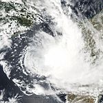
Duration December 29 – January 5 Intensity 65 km/h (40 mph) (10-min), 995 mbar (hPa) Early on December 30 an area of disturbed weather formed west of Madagascar and was designated as 06R.[55] Later that day it was upgraded to Tropical Disturbance 06R,[56] whilst the Joint Typhoon Warning Center (JTWC) issued a Tropical Cyclone Formation Alert on the developing system.[57] On December 31, Meteo-France upgraded the disturbance to tropical depression status.[58] Soon after, the JTWC upgraded the system to Tropical Cyclone 09S.[59] Early on January 1, the depression was upgraded to Moderate Tropical Storm Elnus, while located in the Mozambique Channel.[60] On January 2, Meteo-France downgraded the system to Tropical Depression ex-Elnus,[61] and then to a tropical disturbance the next day.[62] The JTWC issued its last advisory on January 4 as it transisted to an extratropical system. Meteo-France noted the storm was becoming extratropical on January 4,[63] and on January 6 issued its final advisory on Extratropical Depression ex-Elnus as the system passed to the south of Madagascar.[64]
On January 3, Elnus passed about 75 km (47 mi) east of Europa Island, producing winds up to 57 km/h (37 mph) along with a pressure of 997 hPa (mbar).[65] The storm also enhanced rainfall, peaking around 150 mm (5.9 in), over parts of Malawi, causing minor flooding.[66] Heavy rains in Madagascar briefly displaced 90 families in Antananarivo.[67]
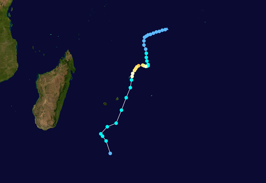
Tropical Disturbance 07
Tropical disturbance (MFR) 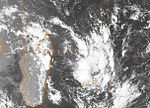
Duration January 6 – January 8 Intensity 35 km/h (25 mph) (10-min), 1003 mbar (hPa) On January 6, the JTWC began monitoring an exposed low-level circulation located about 695 km (432 mi) north of Réunion traveling towards the south. Although moderate wind shear hampered significant development, deep convection developed towards the north of the low.[68] Early the next day, the low was designated as Tropical Disturbance 07-20072008 by Météo-France.[69] Later that day, despite weakening wind shear and increasing convection, the disturbance degenerated into a zone of disturbed weather.[70] Although convection began to decrease by January 8, due to increasing wind shear,[71] Météo-France redesigned the system as a tropical disturbance. At this time, the disturbance was assessed to have reached its peak intensity with winds of 35 km/h (25 mph) with a minimum pressure of 1003 hPa (mbar).[72][73] Later that day, the low rapidly weakened and dissipated while located northwest of Réunion.[74] Due to the proximity to Réunion, the disturbance produced numerous showers and thunderstorms for a few days.[65][70][74]
Tropical Cyclone Fame
Tropical cyclone (MFR) Category 2 tropical cyclone (SSHS) 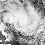
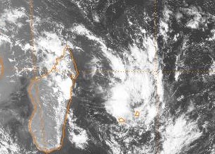
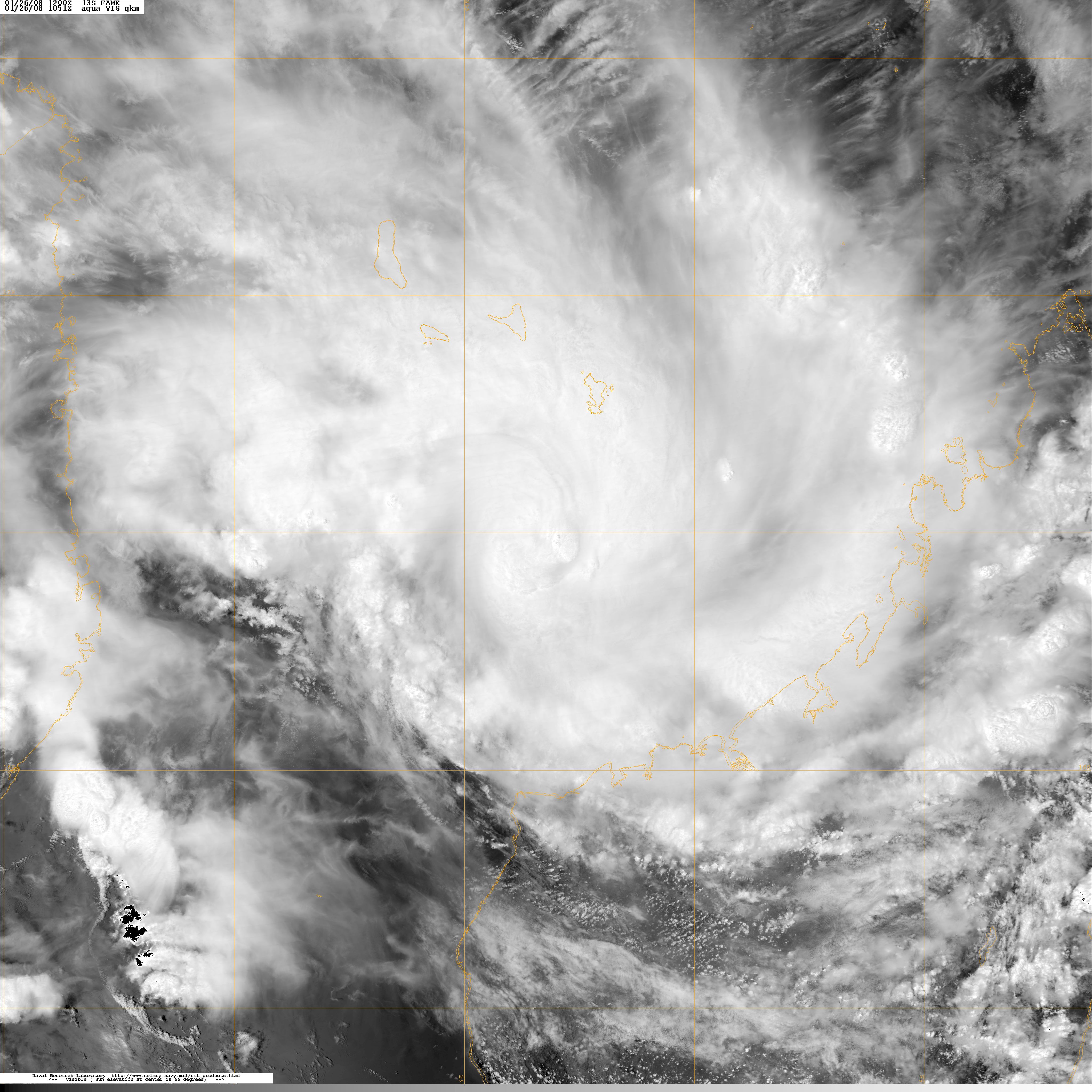
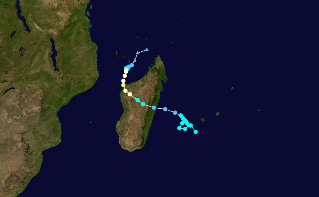
Duration January 22 – February 1 Intensity 130 km/h (80 mph) (10-min), 972 mbar (hPa) An area of disturbed weather formed north of Madagascar and was designated as Tropical Disturbance 08R on January 24. On the next day it was upgraded to Tropical Depression 08R by Météo-France, while the Joint Typhoon Warning Center issued a Tropical Cyclone Formation Alert on the developing system. it was then upgraded to "Moderate Tropical Storm Fame" by the Sub-Regional Tropical Cyclone Advisory Centre in Madagascar. It remained nearly stationary and by January 26 it was upgraded to a severe tropical storm. The storm made landfall over northwestern Madagascar as a severe tropical storm on January 27. Later that day the system temporarily reached tropical cyclone stage just before landfall near Malagasy.[75] It dissipated early on January 28 over Madagascar. The system, however, regenerated on January 29 as it re-emerged over water and became a tropical depression once again.[76] However, Fame did not strengthen further due to interaction with Cyclone Gula, and after being declared extratropical,[77] Météo-France redeclared the system tropical and issued its last advisory.[78]
Strong winds from the storm damaged numerous mobile homes, shrubbery, and trees.[79] At least 13 people were killed[65] and about 20,000 people were left homeless. Maximum sustained winds were recorded up to 120 km/h (75 mph) and rainfall peaked at 146.7 mm (5.7 in) in Besalampy.[80] Total damages from the storm were estimated at 100 million Malagasy ariary ($51,000 USD).[81] After regenerating in the southern Indian Ocean, Fame produced torrential rains over Reunion, peaking at 875 mm (34.4 in) over a three day span, 731 mm (28.7 in) of which fell in 48 hours. The system, in combination with Gula, produced high waves, peaking at 8 m (26.2 ft) along the coasts of Reunion. A peak wind gust of 112 km/h (70 mph) was recorded at Gros Piton Ste-Rose[47]
Tropical Cyclone Gula
Tropical cyclone (MFR) Category 2 tropical cyclone (SSHS) 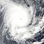
Duration January 25 – February 3 Intensity 155 km/h (100 mph) (10-min), 950 mbar (hPa) An area of disturbed weather formed over the south-central Indian Ocean in the fourth week of January. It slowly developed and Meteo-France began monitoring it as a disturbed area of weather on January 26. It was upgraded to a tropical depression later that day and was named as moderate tropical storm Gula on January 27 by the Mauritius Meteorological Service. Intensification continued and it was upgraded to a severe tropical storm on January 28. The intensification trend became more rapid early on January 29 as a clear eye developed and the storm became a tropical cyclone.[82] After weakening and oscillating between severe and moderate tropical storm status,[78][83][84][85] Météo-France declared it an extratropical depression,[86] and then issued its last advisory on February 2.[87]
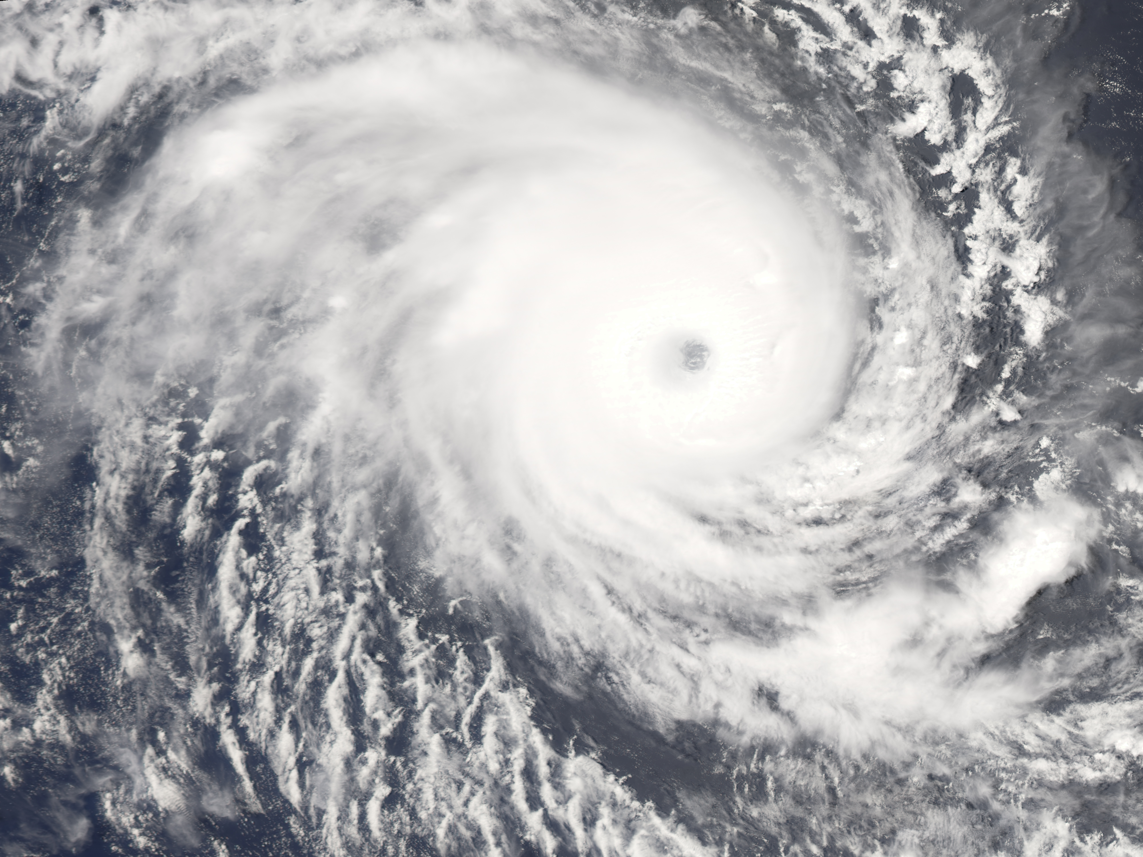
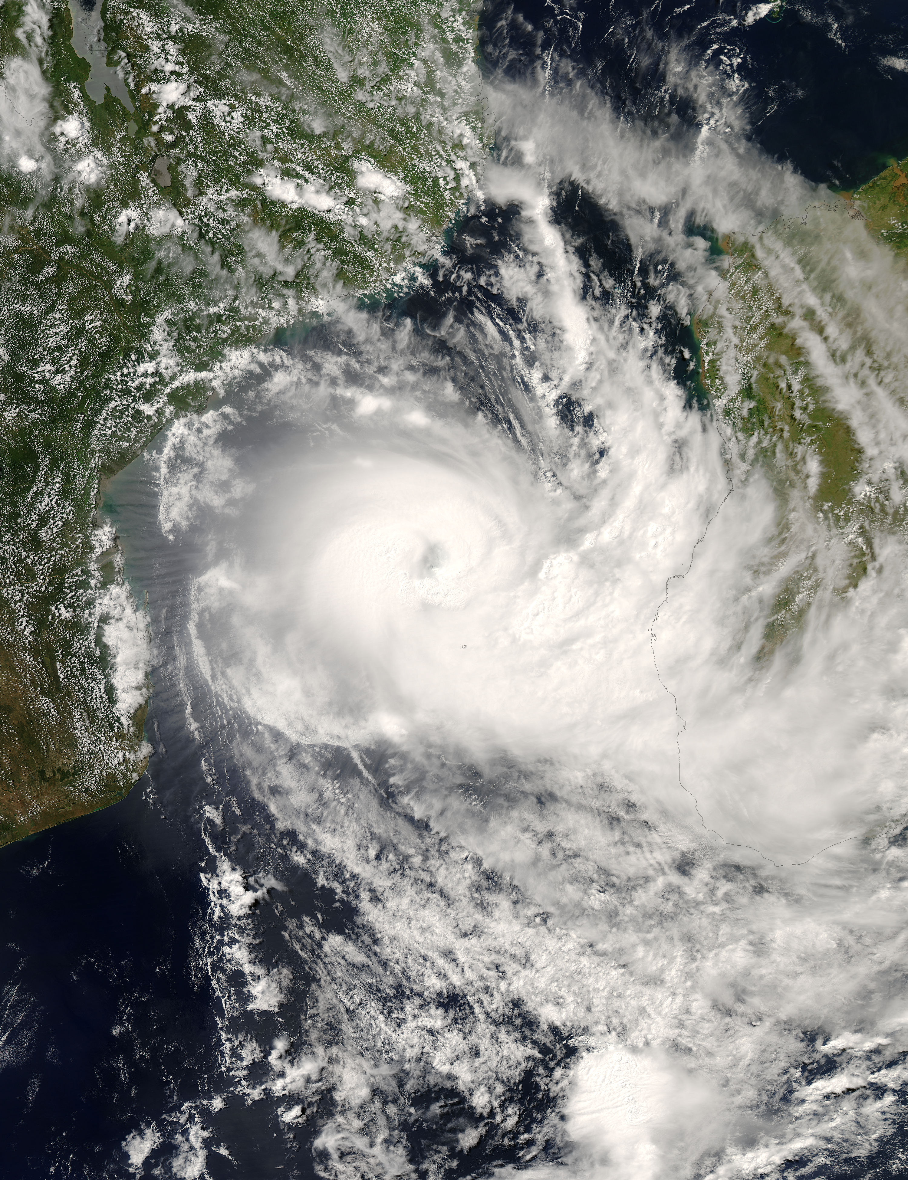
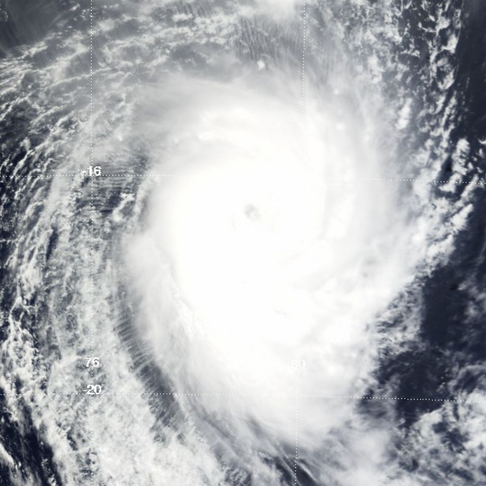
Intense Tropical Cyclone Hondo
Intense tropical cyclone (MFR) Category 4 tropical cyclone (SSHS) 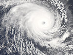
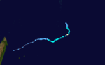
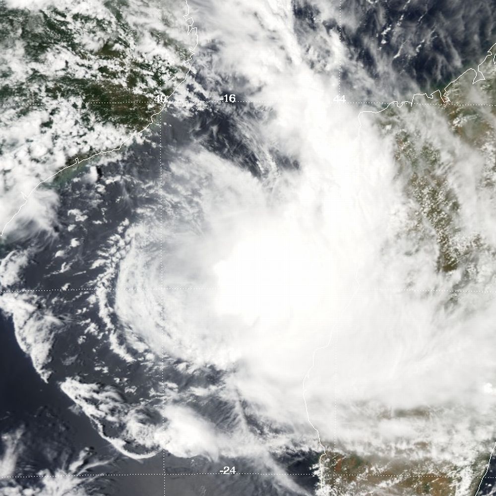
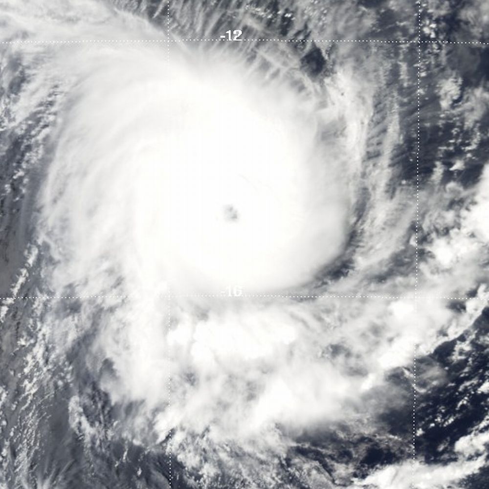
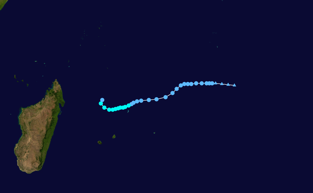
Duration February 2 – February 29 Intensity 215 km/h (130 mph) (10-min), 915 mbar (hPa) Main article: Cyclone HondoThe third tropical cyclone and first intense tropical cyclone of the season, Hondo developed out of a tropical disturbance in early February about 1,020 km (630 mi) east-southeast of Diego Garcia.[88] The disturbance quickly strengthened, becoming a moderate tropical storm on February 4 and a severe tropical storm the following day.[89] After a brief period of slower intensification, Hondo rapidly intensified into an intense tropical cyclone and reached its peak intensity with winds of 215 km/h (130 mph 10-minute winds) on February 7.[89] Around the same time that Météo-France assessed Hondo to have peaked, the JTWC reported that the storm had attained winds of 240 km/h (150 mph 1-minute winds), equivalent to a strong Category 4 hurricane.[90]
The cyclone gradually weakened over the next several days due to an increase in forward speed and a decrease in sea surface temperatures.[91] On February 12, Hondo rapidly degenerated into a remnant-low pressure area.[92] Over the following week, the remnant low traveled in a general west-northwest direction with no development.[89] On February 20, about 2,780 km (1,730 mi) northeast of where the final advisories were issued, the storm began to regenerate.[93] The next day, advisories were issued on Tropical Disturbance Ex-Hondo, which briefly strengthened into a tropical depression.[89] However, according to the Joint Typhoon Warning Center, Hondo continued to strengthen and attained winds of 95 km/h (60 mph 1-minute winds) before passing directly over Réunion.[90] Interaction with the island caused the storm to weaken and degenerate into a remnant low once more. The storm dissipated on February 29 after executing a counterclockwise loop.[89]
Sustained winds of 50 km/h (31 mph) with gusts up to 76 km/h (47 mph) were recorded on Mauritius while sustained winds of 55 km/h (35 mph)[94] with gusts up to 99 km/h (61 mph) were recorded on Réunion. The highest rainfall total was recorded at Takamaka, totaling to 750 mm (29.5 in).[95] Up to 760,000 people were affected on Réunion[96] and overall damage was minimal.[47]
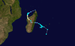
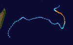
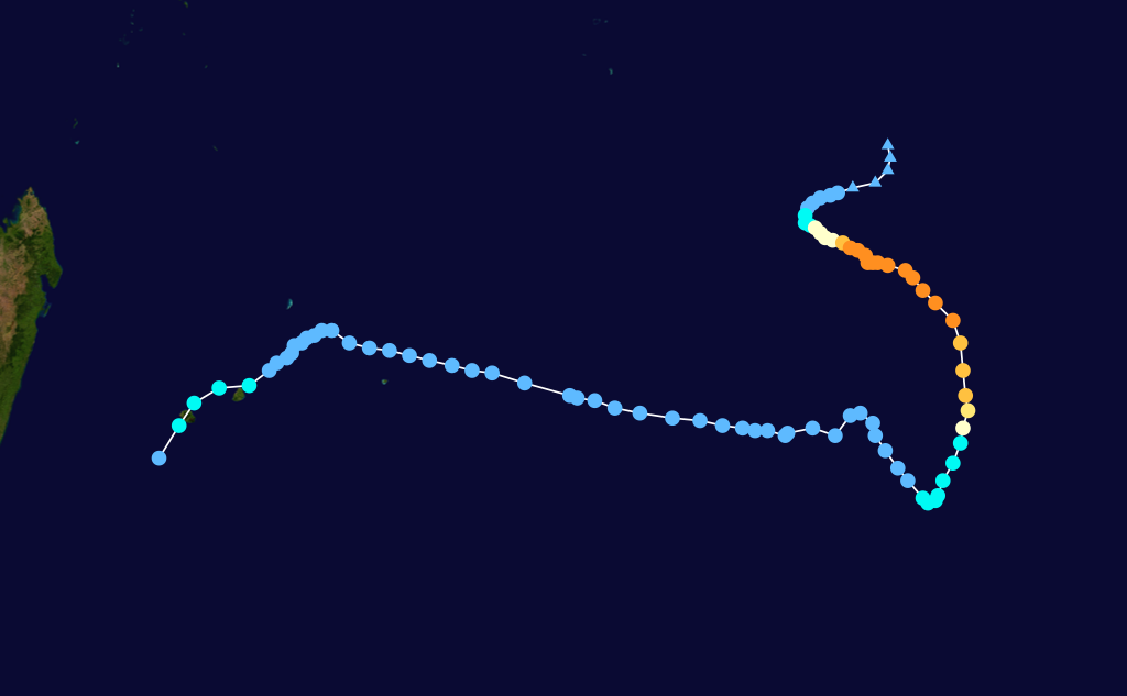
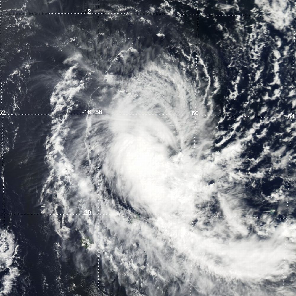
Intense Tropical Cyclone Ivan
Intense tropical cyclone (MFR) Category 4 tropical cyclone (SSHS) 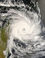
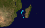
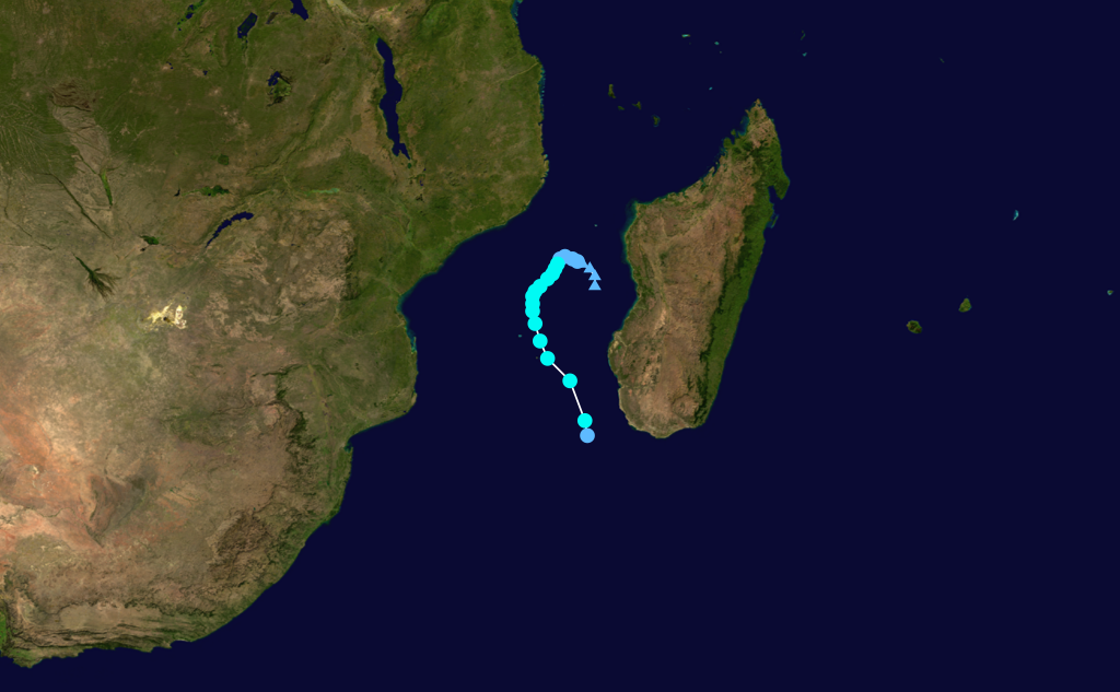
Duration February 5 – February 27 Intensity 185 km/h (115 mph) (10-min), 930 mbar (hPa) Main article: Cyclone IvanEarly on February 7, an area of disturbed weather northeast of Madagascar, heading southeast, was designated Tropical Depression 11R.[97] Like Cyclone Hondo before it, the storm intensified quickly into Moderate Tropical Storm Ivan,[98] then reached severe status a few hours later.[99] Severe status was held until February 11, when Ivan became a tropical cyclone for a short time.[100] Ivan was moving quite slowly, and this, coupled with medium shear, weakened it to moderate tropical storm status by February 12.[101][101] During this time, Ivan made two complete loops in the open sea.[102] However, by February 14, it had sped up and entered a more favourable environment, becoming a severe tropical storm.[103] On February 15, Ivan was reupgraded to a tropical cyclone as favourable conditions persisted. Ivan was further upgraded to an Intense Tropical Cyclone on February 16 as it moved closer to Madagascar. Ivan made landfall north of Fanoarivo, Madagascar on February 17.[104] Once overland, rapid weakening occurred due to the rugged terrain of the island.[105] Ivan was forecast to regenerate over the Mozambique Channel into a tropical depression once it left Madagascar.[106]
Ivan traversed Madagascar, heading southwest. Its remnants emerged back over water on February 21, and Météo-France resumed advisories on "filling depression Ex-Ivan".[107] Ivan, severely disrupted by Madagascar, did not strengthen any further; the last advisory was issued on February 22.[108]
A preliminary casualty estimate due to Ivan is 93. The cyclone left over 330,000 homeless.[109] Sainte Marie, the island where Ivan made landfall, is estimated to have 75% of its buildings completely destroyed.[110] Total damages from Ivan total more than $30 million (2008 USD).
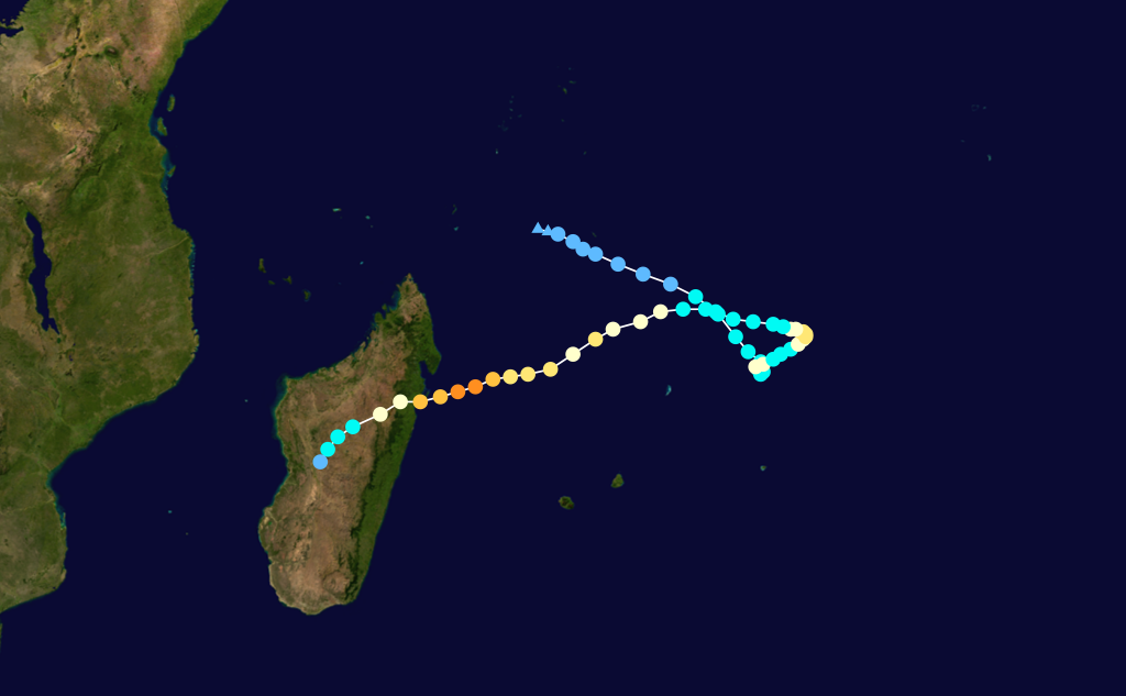
Intense Tropical Cyclone Jokwe
Intense tropical cyclone (MFR) Category 3 tropical cyclone (SSHS) 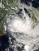
Duration March 2 – March 16 Intensity 195 km/h (120 mph) (10-min), 940 mbar (hPa) Main article: Cyclone JokweOn March 4, the JTWC issued a Tropical Cyclone Formation Alert on an area of disturbed weather developing northeast of Madagascar.[111] Soon after, Météo-France upgraded the system to tropical disturbance status.[112] Early on March 5, the JTWC issued its first advisory on the developing system, designating it as Tropical Cyclone 22S.[113] Later that day, the disturbance was upgraded to Moderate Tropical Storm Jokwe.[114] At noon on March 6, after a bout of rapid intensification, Jokwe was upgraded to a tropical cyclone, skipping severe storm status.[115] After being briefly downgraded to a severe tropical storm,[116] Jokwe was reupgraded to a tropical cyclone,[117] then an intense tropical cyclone on the evening of March 7.[118] Jokwe made landfall between Mozambique Island and Angoche Island early on March 8.[119]
Over the next two days, Jokwe fell down to severe tropical storm following land interaction with Mozambique.[119][120] Later that day, Jokwe was reupgraded to a tropical cyclone,[121] and became an intense tropical cyclone again early on March 11.[122] Jokwe then came under the influence of moderate windshear, and weakened down to a severe tropical storm again by March 12.[123][124] Jokwe was re-upgraded to a Tropical Cyclone early March 13,[125] but was soon downgraded again to a severe tropical storm later that day due to another increase in wind shear.[126] Shear had been steadily increasing, and on March 13 Jokwe's movement slowed down drastically; it moved around the same general area of ocean and weakened.[127][128][129] Final warnings were issued by the JTWC late March 14,[130] and by Météo-France early March 15.[131]
44 houses were destroyed in Madagascar as Jokwe hit the northern tip of the island. At least 20 people were killed and over 9,000 homes destroyed as Jokwe passed through north-eastern Mozambique. At least 100,000 have been displaced by Jokwe. The United Nations World Food Program (WFP) provided emergency food aid to 60,000 people affected by Jokwe in Mozambique.[132]
Intense Tropical Cyclone Kamba
Intense tropical cyclone (MFR) Category 4 tropical cyclone (SSHS) 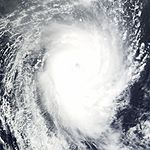

Duration March 5 – March 14 Intensity 185 km/h (115 mph) (10-min), 930 mbar (hPa) Main article: Cyclone KambaThe fourth and final intense tropical cyclone of the season, Kamba developed out of an area of disturbed weather just outside Météo France's area of responsibility on March 5.[133] Over the next several days, the system intensified, becoming a moderate tropical storm, at which time it was named Kamba, late on March 8. Rapid intensification followed shortly thereafter, as an eye developed over the center of the cyclone,[134] with Kamba becoming an intense tropical cyclone on March 10.[133] Around this time, the JTWC assessed Kamba to have attained winds of 215 km/h (135 mph), equivalent to a low-end Category 4 hurricane.[135] Shortly thereafter, the cyclone moved over cooler waters and into a less favorable environment.[136] By March 12, Kamba rapidly degenerated into a remnant-low pressure area and dissipated two days later.[133]
Moderate Tropical Storm Lola
Moderate tropical storm (MFR) Tropical storm (SSHS) 
Duration March 18 – March 31 Intensity 65 km/h (40 mph) (10-min), 994 mbar (hPa) An area of disturbed weather north east of Mauritius, identified on March 20,[137] became a tropical disturbance on March 21,[138] and a depression later that day.[139] The JTWC initiated advisories on Tropical Cyclone 25S around the same time.[140] The system became Moderate Tropical Storm Lola early March 22 based on it having gale-force winds in the southern quadrant far away from the center and due to it having deep convection.[141] Lola weakened back to a tropical depression that afternoon as it began to suffer from moderate to strong northeasterly shear.[142] It alternated between depression and disturbance a few times,[143][144][145] until the final advisory was issued on a zone of disturbed weather on March 26.[146] The JTWC had issued its final advisory two days earlier, on March 24.[147]
Storm names
A tropical disturbance is named when it reaches moderate tropical storm strength. If a tropical disturbance reaches moderate tropical storm status west of 55°E, then the Sub-regional Tropical Cyclone Advisory Centre in Madagascar assigns the appropriate name to the storm. If a tropical disturbance reaches moderate tropical storm status between 55°E and 90°E, then the Sub-regional Tropical Cyclone Advisory Centre in Mauritius assigns the appropriate name to the storm. A new annual list is used every year so no names are retired.[148]
- Sama (unused)
- Tuma (unused)
- Uzale (unused)
- Vongai (unused)
- Warona (unused)
- Xina (unused)
- Yamba (unused)
- Zefa (unused)
Season effects
This table lists all the storms that developed in the Southern Hemisphere during the 2007-2008 South-West Indian Ocean cyclone season. It includes their intensity, duration, name, landfalls, deaths, and damages. All data is taken from Météo-France.
2007-08 South-West Indian cyclone statistics Storm name Active dates Storm category at peak intensity
Max wind
(mph)
Min. press.
(mbar)
Landfall(s) Damage (millions
USD)
Deaths Where When Wind (mph)
01 October 12 – October 13 Tropical disturbance 30 1005 none none 0 Ariel November 12 – November 18 Severe tropical storm 60 985 none none 0 Bongwe November 17 – November 28 Severe tropical storm 65 976 none none 0 Celina December 11 – December 23 Moderate tropical storm 45 992 none none 1 Dama December 17 – December 24 Moderate tropical storm 40 995 none none 0 Elnus December 29 – January 5 Moderate tropical storm 40 995 none none 0 07 January 6 – January 8 Tropical disturbance 25 1003 none none 0 Fame January 22 – February 1 Tropical cyclone 80 972 Malagasy, Madagascar January 27 80 0.05 13 Gula January 25 – February 3 Tropical cyclone 100 950 none none 0 Hondo February 2 – February 29 Intense tropical cyclone 130 915 Mauritius (Direct hit, no landfall) February 23 35 minimal 0 Réunion February 23 35 Ivan February 5 – February 27 Intense tropical cyclone 115 930 Fanoarivo, Madagascar February 17 115 30 93 Jokwe March 2 – March 16 Intense tropical cyclone 120 940 Northern Madagascar March 6 60 8 16 Angoche, Mozambique March 8 120 Kamba March 5 – March 14 Intense tropical cyclone 115 930 none none 0 Lola March 18 – March 31 Moderate tropical storm 40 994 none none 4 Season Aggregates 14 Disturbances October 12 –March 31 130 915 5 landfalls 30.05 127 See also
- Tropical cyclone scales
- List of Southern Hemisphere tropical cyclone seasons
- Atlantic hurricane seasons: 2007, 2008
- Pacific hurricane seasons: 2007, 2008
- Pacific typhoon seasons: 2007, 2008
- North Indian Ocean cyclone seasons: 2007, 2008
References
- ^ a b Gary Padgett (October 14, 2007). "Monthly Global Tropical Cyclone Summary for July 2007". Typhoon 2000. http://www.typhoon2000.ph/garyp_mgtcs/jul07sum.txt. Retrieved January 26, 2009.
- ^ "Tropical Disturbance 01 (July) advisory page". Météo-France. 2007. Archived from the original on August 22, 2008. http://web.archive.org/web/20080822145059/http://img175.imageshack.us/img175/3108/tropicaldisturbance16rrc9.jpg. Retrieved January 26, 2009.
- ^ a b "Tropical Cyclone Formation Alert 07-29-2007 21Z". Joint Typhoon Warning Center. http://www.webcitation.org/5TAuMTWMe. Retrieved January 26, 2009.
- ^ a b Joe Courtney (August 16, 2007). "Perth Tropical Cyclone Report: Unnamed Tropical Cyclone" (PDF). Australian Bureau of Meteorology. http://www.bom.gov.au/weather/wa/cyclone/about/Unnamed_report.pdf. Retrieved January 26, 2009.
- ^ "Tropical Cyclone Advisories for July 29, 2007". Unisys Corporation. http://www.weather.unisys.com/hurricane/archive/07072918. Retrieved January 26, 2009.
- ^ "Significant Tropical Weather Advisory for the Indian Ocean 10-10-2007 08Z". Joint Typhoon Warning Center. ftp://ftp.met.fsu.edu/pub/weather/tropical/GuamStuff/2007101008-ABIO.PGTW. Retrieved January 26, 2009.
- ^ "Significant Tropical Weather Advisory for the Indian Ocean 10-10-2007 23Z". Joint Typhoon Warning Center. ftp://ftp.met.fsu.edu/pub/weather/tropical/GuamStuff/2007101023-ABIO.PGTW. Retrieved January 26, 2009.
- ^ "Tropical cyclone Warning 10-12-2007 06z". Météo-France. http://www.webcitation.org/5SWtFt9pr. Retrieved January 26, 2009.
- ^ a b Gary Padgett (June 21, 2008). "Monthly Global Tropical Cyclone Summary for October 2007". Australian Severe Weather. http://www.australiasevereweather.com/cyclones/2008/summ0710a.htm. Retrieved February 2, 2009.
- ^ "Tropical cyclone Warning 10-13-2007 12z". Météo-France. http://www.webcitation.org/5SZ007y9C. Retrieved January 26, 2009.
- ^ "High Seas Warning 11-13-2007 07z". Australian Bureau of Meteorology. ftp://ftp.met.fsu.edu/pub/weather/tropical/Australia/2007111307.WTAUT. Retrieved February 1, 2009.
- ^ "High Seas Warning 11-14-2007 13z". Australian Bureau of Meteorology. ftp://ftp.met.fsu.edu/pub/weather/tropical/Australia/2007111413.WTAUT. Retrieved February 1, 2009.
- ^ "WTXS21 11-14-2007 16z". Joint Typhoon Warning Center. http://www.webcitation.org/5TLpobZym. Retrieved February 1, 2009.
- ^ "WTXS31 11-14-2007 21z". Joint Typhoon Warning Center. http://www.webcitation.org/5TLxneSwB. Retrieved February 1, 2009.
- ^ "High Seas Warning 11-15-2007 01z". Australian Bureau of Meteorology. ftp://ftp.met.fsu.edu/pub/weather/tropical/Australia/2007111501.WTAUT. Retrieved February 1, 2009.
- ^ "Tropical cyclone Warning 11-15-2007 12z". Météo-France. ftp://ftp.met.fsu.edu/pub/weather/tropical/Seychelles/2007111512-FMEE. Retrieved February 1, 2009.
- ^ "JTWC Best Track for Cyclone 03S (Lee-Ariel)". Joint Typhoon Warning Center. 2009. http://www.usno.navy.mil/NOOC/nmfc-ph/RSS/jtwc/best_tracks/2008/2008s-bsh/bsh032008.txt. Retrieved September 19, 2009.
- ^ "WTXS31 11-15-2007 18z". Joint Typhoon Warning Center. http://www.webcitation.org/5TNgPmaNs. Retrieved February 1, 2009.
- ^ "Tropical cyclone Warning 11-16-2007 00z". Météo-France. ftp://ftp.met.fsu.edu/pub/weather/tropical/Seychelles/2007111600-FMEE. Retrieved February 1, 2009.
- ^ "Tropical cyclone Warning 11-16-2007 18z". Météo-France. ftp://ftp.met.fsu.edu/pub/weather/tropical/Seychelles/2007111618-FMEE. Retrieved February 1, 2009.
- ^ "Tropical cyclone Warning 11-17-2007 00z". Météo-France. ftp://ftp.met.fsu.edu/pub/weather/tropical/Seychelles/2007111700-FMEE. Retrieved February 1, 2009.
- ^ "Tropical cyclone Warning 11-17-2007 06z". Météo-France. ftp://ftp.met.fsu.edu/pub/weather/tropical/Seychelles/2007111706-FMEE. Retrieved February 2, 2009.
- ^ "Tropical cyclone Warning 11-18-2007 18z". Météo-France. ftp://ftp.met.fsu.edu/pub/weather/tropical/Seychelles/2007111818-FMEE. Retrieved February 2, 2009.
- ^ "Météo-France Best Track for Severe Tropical Storm Lee-Ariel". Météo-France. 2009. http://www.meteo.fr/temps/domtom/La_Reunion/TGPR/saison20072008B/02_table.html. Retrieved February 2, 2009.
- ^ http://www.webcitation.org/5TQclIV2X
- ^ http://www.webcitation.org/5TRsUdOLl
- ^ ftp://ftp.met.fsu.edu/pub/weather/tropical/Seychelles/2007111812-FMEE
- ^ ftp://ftp.met.fsu.edu/pub/weather/tropical/Seychelles/2007111818-FMEE
- ^ ftp://ftp.met.fsu.edu/pub/weather/tropical/Seychelles/2007111906-FMEE
- ^ ftp://ftp.met.fsu.edu/pub/weather/tropical/Seychelles/2007111918-FMEE
- ^ ftp://ftp.met.fsu.edu/pub/weather/tropical/Seychelles/2007112018-FMEE
- ^ ftp://ftp.met.fsu.edu/pub/weather/tropical/Seychelles/2007112200-FMEE
- ^ ftp://ftp.met.fsu.edu/pub/weather/tropical/Seychelles/2007112300-FMEE
- ^ ftp://ftp.met.fsu.edu/pub/weather/tropical/Seychelles/2007112318-FMEE
- ^ ftp://ftp.met.fsu.edu/pub/weather/tropical/Seychelles/2007112400-FMEE
- ^ ftp://ftp.met.fsu.edu/pub/weather/tropical/Seychelles/2007112413-FMEE
- ^ ftp://ftp.met.fsu.edu/pub/weather/tropical/Seychelles/2007121212-FMEE
- ^ "Warning For Metarea VIII". Rsmc La Reunion. Meteo France. December 12. ftp://ftp.met.fsu.edu/pub/weather/tropical/Seychelles/2007121212-FMEE. Retrieved December 12.
- ^ "Tropical Cyclone Formation Alert". JTWC. Joint Typhoon Warning Center. December 12. http://www.webcitation.org/5TpDlWYzi. Retrieved December 12.
- ^ http://weather.unisys.com/hurricane/archive/07121306
- ^ ftp://ftp.met.fsu.edu/pub/weather/tropical/Seychelles/2007121406-FMEE
- ^ ftp://ftp.met.fsu.edu/pub/weather/tropical/Seychelles/2007121706-FMEE
- ^ http://www.webcitation.org/5UAZYvJrX
- ^ ftp://ftp.met.fsu.edu/pub/weather/tropical/Seychelles/2007121812-FMEE
- ^ ftp://ftp.met.fsu.edu/pub/weather/tropical/Seychelles/2007121912-FMEE
- ^ a b ftp://ftp.met.fsu.edu/pub/weather/tropical/Seychelles/2007122112-FMEE
- ^ a b c (French) Météo-France (September 5, 2008). "Bilan des Alertes Cycloniques en 2006-2008 à La Reunion et à Mayotte" (PDF). World Meteorological Organization. http://www.wmo.ch/pages/prog/www/tcp/Meetings/documents/Reunion_consolidated_2006-2008.pdf. Retrieved February 3, 2009.
- ^ http://www.webcitation.org/5UAiT6r8J
- ^ ftp://ftp.met.fsu.edu/pub/weather/tropical/Seychelles/2007121811-FMEE
- ^ http://www.webcitation.org/5UBPEGNBk
- ^ ftp://ftp.met.fsu.edu/pub/weather/tropical/Seychelles/2007121818-FMEE
- ^ ftp://ftp.met.fsu.edu/pub/weather/tropical/Seychelles/2007122000-FMEE
- ^ ftp://ftp.met.fsu.edu/pub/weather/tropical/Seychelles/2007122012-FMEE
- ^ http://www.webcitation.org/5UFrq8ScW
- ^ ftp://ftp.met.fsu.edu/pub/weather/tropical/Seychelles/2007123012-FMEE
- ^ ftp://ftp.met.fsu.edu/pub/weather/tropical/Seychelles/2007123100-FMEE
- ^ http://www.webcitation.org/5UUIbu0Hm
- ^ ftp://ftp.met.fsu.edu/pub/weather/tropical/Seychelles/2007123106-FMEE
- ^ http://www.webcitation.org/5UV4fC2fu
- ^ ftp://ftp.met.fsu.edu/pub/weather/tropical/Seychelles/2008010100-FMEE
- ^ ftp://ftp.met.fsu.edu/pub/weather/tropical/Seychelles/2008010206-FMEE
- ^ ftp://ftp.met.fsu.edu/pub/weather/tropical/Seychelles/2008010312-FMEE
- ^ ftp://ftp.met.fsu.edu/pub/weather/tropical/Seychelles/2008010406-FMEE
- ^ ftp://ftp.met.fsu.edu/pub/weather/tropical/Seychelles/2008010512-FMEE
- ^ a b c Gary Padgett (March 29, 2008). "Monthly Global Tropical Cyclone Summary for January 2008". Typhoon 2000. http://www.typhoon2000.ph/garyp_mgtcs/jan08sum.txt. Retrieved February 1, 2009.
- ^ Tropical Cyclone Committee (October 10, 2008). "Malawi: Review of the 2005/2006, 2006/2007 and 2007/2008 Cyclone Seasons". World Meteorological Organization. http://www.wmo.int/pages/prog/www/tcp/Meetings/documents/Doc.4.2_4.doc. Retrieved February 1, 2009.
- ^ Alfred Nabeta and John Roche (January 16, 2008). "Briefing on the Southern African Floods". Inter-Agency Standing Committee. http://www.humanitarianinfo.org/iasc/downloaddoc.aspx?docId=4236. Retrieved February 1, 2009.
- ^ "Significant Tropical Weather Advisory for the Indian Ocean 01-06-2008 12Z". Joint Typhoon Warning Center. http://www.webcitation.org/5UeDliKCg. Retrieved January 26, 2009.
- ^ "Tropical cyclone Warning 07-01-2008 00z". Météo-France. ftp://ftp.met.fsu.edu/pub/weather/tropical/Seychelles/2008010700-FMEE. Retrieved January 26, 2009.
- ^ a b "Tropical cyclone Warning 01-07-2008 12z". Météo-France. ftp://ftp.met.fsu.edu/pub/weather/tropical/Seychelles/2008010712-FMEE. Retrieved January 26, 2009.
- ^ "Significant Tropical Weather Advisory for the Indian Ocean 01-07-2008 23Z". Joint Typhoon Warning Center. http://www.webcitation.org/5Ugeo8owJ. Retrieved January 26, 2009.
- ^ "Tropical cyclone Warning 01-08-2008 00z". Météo-France. ftp://ftp.met.fsu.edu/pub/weather/tropical/Seychelles/2008010800-FMEE. Retrieved January 26, 2009.
- ^ "Météo-France Storm Track for Tropical Disturbance 07". Météo-France. http://www.meteo.fr/temps/domtom/La_Reunion/TGPR/saison20072008/07_table.html. Retrieved January 26, 2009.
- ^ a b "Tropical cyclone Warning 01-08-2008 12z". Météo-France. ftp://ftp.met.fsu.edu/pub/weather/tropical/Seychelles/2008010812-FMEE. Retrieved January 26, 2009.
- ^ ftp://ftp.met.fsu.edu/pub/weather/tropical/Seychelles/2008012718-FMEE
- ^ ftp://ftp.met.fsu.edu/pub/weather/tropical/Seychelles/2008012918-FMEE
- ^ ftp://ftp.met.fsu.edu/pub/weather/tropical/Seychelles/2008020106-FMEE
- ^ a b ftp://ftp.met.fsu.edu/pub/weather/tropical/Seychelles/2008020112-FMEE
- ^ "Daily Monitoring and Alert Service 28 Jan 2008". MIC Daily. January 28, 2008. http://dmaweb1.jrc.it/MIC/MICdailyreports/2008-01-28%20MIC%20DAILY.doc. Retrieved February 1, 2009.[dead link]
- ^ Tropical Cyclone Committee (September 5, 2008). "Madagascar: Review of the 2005/2006, 2006/2007 and 2007/2008 Cyclone Seasons". World Meteorological Organization. http://www.wmo.ch/pages/prog/www/tcp/Meetings/documents/d04-2_3_en.doc. Retrieved February 3, 2009.
- ^ Bureau National de Gestion des Risques et des Catastrophes (February 13, 2008). "Tropical Cyclone Fame full report" (PDF). ReliefWeb. Archived from the original on March 13, 2008. http://web.archive.org/web/20080313205946/http://www.reliefweb.int/rw/rwb.nsf/retrieveattachments?openagent&shortid=YSAR-7CDU47&file=Full_Report.pdf. Retrieved February 1, 2009.
- ^ ftp://ftp.met.fsu.edu/pub/weather/tropical/Seychelles/2008012906-FMEE
- ^ ftp://ftp.met.fsu.edu/pub/weather/tropical/Seychelles/2008013006-FMEE
- ^ ftp://ftp.met.fsu.edu/pub/weather/tropical/Seychelles/2008013012-FMEE
- ^ ftp://ftp.met.fsu.edu/pub/weather/tropical/Seychelles/2008020100-FMEE
- ^ ftp://ftp.met.fsu.edu/pub/weather/tropical/Seychelles/2008020118-FMEE
- ^ ftp://ftp.met.fsu.edu/pub/weather/tropical/Seychelles/2008020200-FMEE
- ^ "Tropical cyclone Warning 02-04-2008 06z". Météo-France. ftp://ftp.met.fsu.edu/pub/weather/tropical/Seychelles/2008020406-FMEE. Retrieved September 19, 2009.
- ^ a b c d e (French) "Données Relatives au Système Dépressionnaire Tropical 13: Cyclone Tropical Intense Hondo". Météo France. August 8, 2008. http://www.meteo.fr/temps/domtom/La_Reunion/TGPR/saison20072008B/10_table.html. Retrieved September 19, 2009.
- ^ a b "JTWC Best Track for Cyclone 16S (Hondo)". Joint Typhoon Warning Center. 2009. http://www.usno.navy.mil/NOOC/nmfc-ph/RSS/jtwc/best_tracks/2008/2008s-bsh/bsh162008.txt. Retrieved September 19, 2009.
- ^ "Tropical cyclone Warning 02-11-2008 12z". Météo-France. ftp://ftp.met.fsu.edu/pub/weather/tropical/Seychelles/2008021112-FMEE. Retrieved September 19, 2009.
- ^ "Tropical cyclone Warning 02-12-2008 12z". Météo-France. ftp://ftp.met.fsu.edu/pub/weather/tropical/Seychelles/2008021212-FMEE. Retrieved September 19, 2009.
- ^ Gary Padgett (June 11, 2008). "Monthly Global Tropical Cyclone Summary for February 2008". Typhoon 2000. http://www.typhoon2000.ph/garyp_mgtcs/feb08sum.txt. Retrieved September 19, 2009.
- ^ Gary Padgett (June 11, 2008). "Monthly Global Tropical Cyclone Summary for February 2008". Typhoon 2000. http://www.typhoon2000.ph/garyp_mgtcs/feb08sum.txt. Retrieved February 14, 2009.
- ^ (French) Météo-France (September 5, 2008). "Bilan des Alertes Cycloniques en 2006-2008 à La Reunion et à Mayotte" (PDF). World Meteorological Organization. http://www.wmo.ch/pages/prog/www/tcp/Meetings/documents/Reunion_consolidated_2006-2008.pdf. Retrieved February 14, 2009.
- ^ Global Disaster Alert and Coordination System (September 7, 2008). "Green Tropical cyclone alert: Tropical Cyclone Hondo-08". Pacific Disaster Center. http://www.gdacs.org/reports.asp?eventType=TC&ID=HONDO-08&system=asgard&alertlevel=Green&glide_no=&location=&country=&new=true. Retrieved February 14, 2009.
- ^ ftp://ftp.met.fsu.edu/pub/weather/tropical/Seychelles/2008020706-FMEE
- ^ ftp://ftp.met.fsu.edu/pub/weather/tropical/Seychelles/2008020712-FMEE
- ^ ftp://ftp.met.fsu.edu/pub/weather/tropical/Seychelles/2008020718-FMEE
- ^ ftp://ftp.met.fsu.edu/pub/weather/tropical/Seychelles/2008021112-FMEE
- ^ a b ftp://ftp.met.fsu.edu/pub/weather/tropical/Seychelles/2008021218-FMEE
- ^ http://www.meteo.fr/temps/domtom/La_Reunion/TGPR/saison/images/trajectoire/Traj_Complete_11.png Archived 11 March 2008 at WebCite
- ^ ftp://ftp.met.fsu.edu/pub/weather/tropical/Seychelles/2008021406-FMEE
- ^ ftp://ftp.met.fsu.edu/pub/weather/tropical/Seychelles/2008021706-FMEE
- ^ ftp://ftp.met.fsu.edu/pub/weather/tropical/Seychelles/2008021712-FMEE
- ^ ftp://ftp.met.fsu.edu/pub/weather/tropical/Seychelles/2008021812-FMEE
- ^ ftp://ftp.met.fsu.edu/pub/weather/tropical/Seychelles/2008022101-FMEE
- ^ ftp://ftp.met.fsu.edu/pub/weather/tropical/Seychelles/2008022212-FMEE
- ^ Reuters South Africa (March 8, 2008). "Death toll from Madagascar cyclone rises to 93". http://africa.reuters.com/top/news/usnBAN847241.html. Retrieved 2008-03-09.
- ^ http://www.webcitation.org/5VoOQ2y3Y
- ^ http://www.webcitation.org/5W4fmx8ga
- ^ ftp://ftp.met.fsu.edu/pub/weather/tropical/Seychelles/2008030418-FMEE
- ^ http://www.webcitation.org/5W55cS0vU
- ^ ftp://ftp.met.fsu.edu/pub/weather/tropical/Seychelles/2008030512-FMEE
- ^ ftp://ftp.met.fsu.edu/pub/weather/tropical/Seychelles/2008030612-FMEE
- ^ ftp://ftp.met.fsu.edu/pub/weather/tropical/Seychelles/2008030700-FMEE
- ^ http://weather.unisys.com/hurricane/archive/08030712
- ^ ftp://ftp.met.fsu.edu/pub/weather/tropical/Seychelles/2008030718-FMEE
- ^ a b ftp://ftp.met.fsu.edu/pub/weather/tropical/Seychelles/2008030812-FMEE
- ^ ftp://ftp.met.fsu.edu/pub/weather/tropical/Seychelles/2008030906-FMEE
- ^ ftp://ftp.met.fsu.edu/pub/weather/tropical/Seychelles/2008030918-FMEE
- ^ ftp://ftp.met.fsu.edu/pub/weather/tropical/Seychelles/2008031100-FMEE
- ^ ftp://ftp.met.fsu.edu/pub/weather/tropical/Seychelles/2008031106-FMEE
- ^ ftp://ftp.met.fsu.edu/pub/weather/tropical/Seychelles/2008031200-FMEE
- ^ ftp://ftp.met.fsu.edu/pub/weather/tropical/Seychelles/2008031306-FMEE
- ^ ftp://ftp.met.fsu.edu/pub/weather/tropical/Seychelles/2008031318-FMEE
- ^ ftp://ftp.met.fsu.edu/pub/weather/tropical/Seychelles/2008031312-FMEE
- ^ ftp://ftp.met.fsu.edu/pub/weather/tropical/Seychelles/2008031406-FMEE
- ^ ftp://ftp.met.fsu.edu/pub/weather/tropical/Seychelles/2008031418-FMEE
- ^ http://weather.unisys.com/hurricane/archive/08031418
- ^ ftp://ftp.met.fsu.edu/pub/weather/tropical/Seychelles/2008031500-FMEE
- ^ IRIN 2008, 'MOZAMBIQUE: WFP to feed Jokwe stricken', www.irinnews.org, 17 March. Retrieved on 18 March 2008.
- ^ a b c (French) "Données Relatives au Système Dépressionnaire Tropical 13: Cyclone Tropical Intense Kamba". Météo France. August 8, 2008. http://www.meteo.fr/temps/domtom/La_Reunion/TGPR/saison20072008B/13_table.html. Retrieved February 8, 2009.
- ^ "Tropical cyclone Warning 03-10-2008 00z". Météo-France. Archived from the original on May 25, 2011. http://web.archive.org/web/20110525104234/http://weather.unisys.com/hurricane/archive/08031001. Retrieved September 19, 2009.
- ^ "JTWC Best Track for Cyclone 23S (Kamba)". Joint Typhoon Warning Center. 2009. http://www.usno.navy.mil/NOOC/nmfc-ph/RSS/jtwc/best_tracks/2008/2008s-bsh/bsh232008.txt. Retrieved September 19, 2009.
- ^ "Tropical cyclone Warning 03-11-2008 00z". Météo-France. http://weather.unisys.com/hurricane/archive/08031100. Retrieved September 19, 2009.
- ^ ftp://ftp.met.fsu.edu/pub/weather/tropical/Seychelles/2008032012-FMEE
- ^ ftp://ftp.met.fsu.edu/pub/weather/tropical/Seychelles/2008032112-FMEE
- ^ ftp://ftp.met.fsu.edu/pub/weather/tropical/Seychelles/2008032118-FMEE
- ^ http://www.webcitation.org/5WcMhR73G
- ^ ftp://ftp.met.fsu.edu/pub/weather/tropical/Seychelles/2008032200-FMEE
- ^ ftp://ftp.met.fsu.edu/pub/weather/tropical/Seychelles/2008032218-FMEE
- ^ ftp://ftp.met.fsu.edu/pub/weather/tropical/Seychelles/2008032406-FMEE
- ^ ftp://ftp.met.fsu.edu/pub/weather/tropical/Seychelles/2008032506-FMEE
- ^ ftp://ftp.met.fsu.edu/pub/weather/tropical/Seychelles/2008032512-FMEE
- ^ ftp://ftp.met.fsu.edu/pub/weather/tropical/Seychelles/2008032612-FMEE
- ^ http://www.webcitation.org/5WcLIz7wW
- ^ "Tropical Cyclone Operational Plan for the South Pacific and South-East Indian Ocean" (PDF). World Meteorological Organization. 2006. Archived from the original on September 21, 2006. http://web.archive.org/web/20060921213201/http://www.wmo.ch/web/www/TCP/OperationPlans/TCP-12%20Edition%202006-English.pdf. Retrieved 2008-08-15.
External links
- Joint Typhoon Warning Center (JTWC).
- Météo France (RSMC La Réunion).
- World Meteorological Organization
Tropical cyclones of the 2007–08 South-West Indian Ocean cyclone season
MFR Tropical Cyclone Scale DIS TD MTS STS TC ITC VITC  Book ·
  Category ·
  Portal ·
  WikiProject ·
  Commons
2000–09 South-West Indian Ocean cyclone seasons


Wikimedia Foundation. 2010.