- 2006–07 South-West Indian Ocean cyclone season
-
2006–07 South-West Indian Ocean cyclone season 
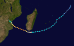
Season summary mapFirst storm formed: November 26, 2006 Last storm dissipated: April 8, 2007 Strongest storm: Dora and Favio – 925 hPa (mbar), 195 km/h (120 mph) (10-minute sustained) Tropical depressions: 11 Total storms: 10 Tropical cyclones: 7 Intense cyclones: 6 Total fatalities: 172 (2 missing) Total damage: $266 million (2007 USD) South-West Indian Ocean cyclone seasons
2004–05, 2005–06, 2006–07, 2007–08, 2008–09Related articles: The 2006–07 South-West Indian Ocean cyclone season was an annual event of tropical cyclone formation which started on November 15, 2006 and ended on April 30, 2007 for most areas and on May 15, 2007 for Mauritius and the Seychelles. These dates conventionally delimit the period of each year when most tropical cyclones form in the basin, which is west of 90°E and south of the Equator. Tropical cyclones in this basin are monitored by the Regional Specialised Meteorological Centre in Réunion.
Pre-season outlook
On October 13, 2006, the Mauritius Meteorological Services issued their seasonal outlook for the Southwest Indian Ocean. They forecast an El Niño-positive phase for the season, meaning that normal to slightly above normal activity was likely.[1] They also forecast a weak Quasi-Biennial Oscillation, which favoured formation of tropical storms, and noted that as 2006 Northern Hemisphere activity was slightly below normal, it might result in slightly above normal activity in the Southwest Indian Ocean.[1] Based on regional indicators, they noted that named tropical storms would not last for short durations. Most other regional factors indicated the likelihood of a normal season.[1] Therefore, the forecast called for about 10 named storms, mostly west of Diego Garcia, with at least one forming in the Mozambique Channel.[1]
Storms

Tropical Disturbance 01
Tropical disturbance (MFR) 
Duration October 19 – October 23 Intensity 35 km/h (25 mph) (10-min), Unknown On October 19, a disturbed area of low pressure near the equator that had persisted for about two days was designated the year's first tropical disturbance by the RSMC on La Réunion. During the following three days, no regular advisories were released because the disturbance was not expected to develop. On October 22, however, the disturbance restrengthened and the issuance of full advisories began because development into a tropical depression was expected. This development did not occur, and on October 23 the final advisory was issued.
Moderate Tropical Storm Anita
Moderate tropical storm (MFR) Tropical storm (SSHS) 

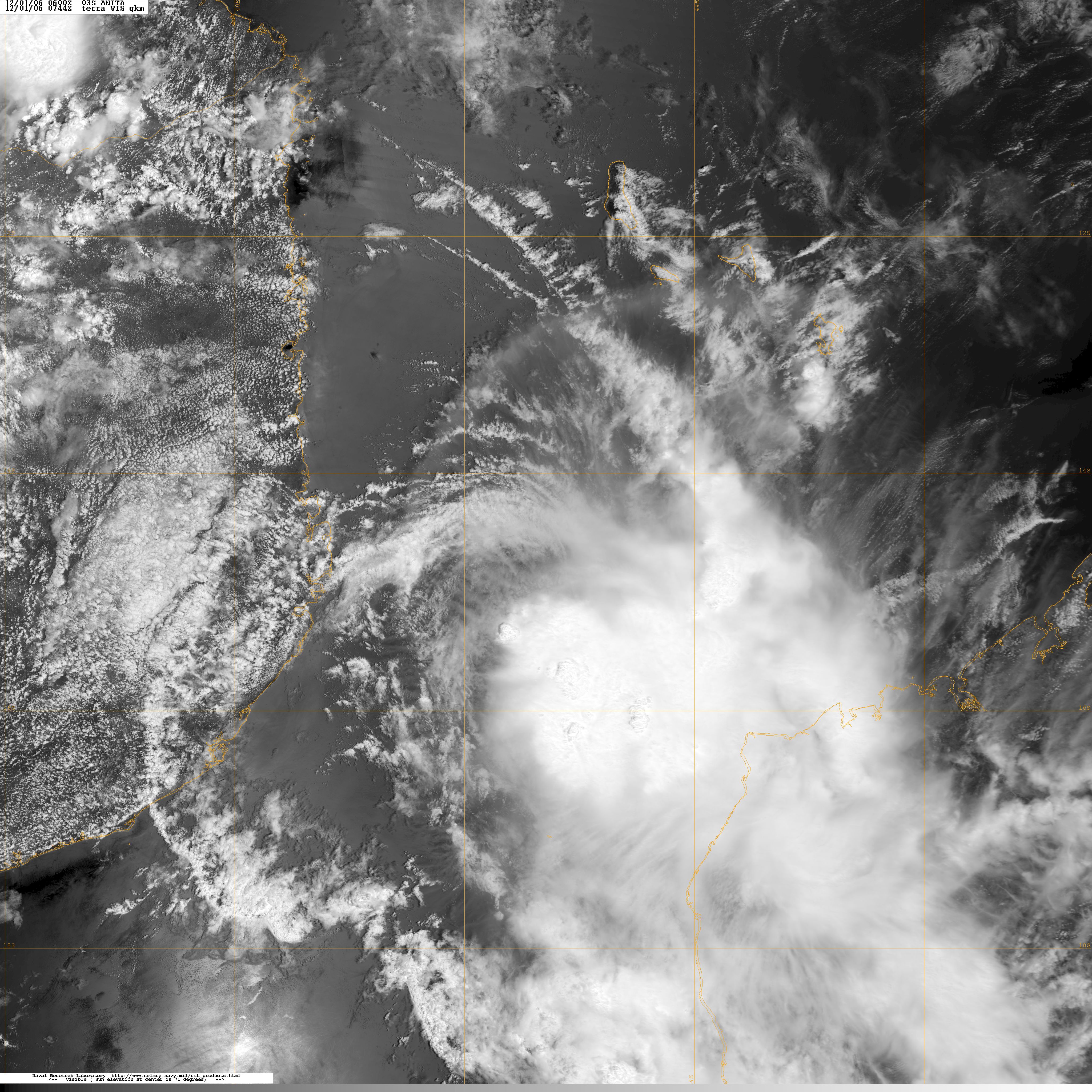
Duration November 26 – December 4 Intensity 65 km/h (40 mph) (10-min), 996 mbar (hPa) On November 25, an area of convection developed near 5°S 55°E . The system was designated a zone perturbée two days later by RSMC La Réunion. It strengthened slightly, and was declared a tropical disturbance on November 27 at 1200 UTC. The Joint Typhoon Warning Center monitored the area for development and on November 29 upgraded the disturbance to a cyclone. RSMC La Réunion upgraded this system to a moderate tropical storm on December 1, and the Subregional Tropical Cyclone Advisory Centre in Madagascar named it "Anita", a name contributed to the list by themselves.[2] Increasing wind shear inhibited any development, and the system failed to intensify further as it moved southward. RSMC La Réunion downgraded Anita to a tropical depression early on December 2. The JTWC ceased advisories on the system at the same time. Anita continued to weaken, and RSMC La Réunion downgraded it to a tropical disturbance later that day, and issued its last advisory early on December 3.
Intense Tropical Cyclone Bondo
Intense tropical cyclone (MFR) Category 4 tropical cyclone (SSHS) 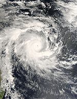

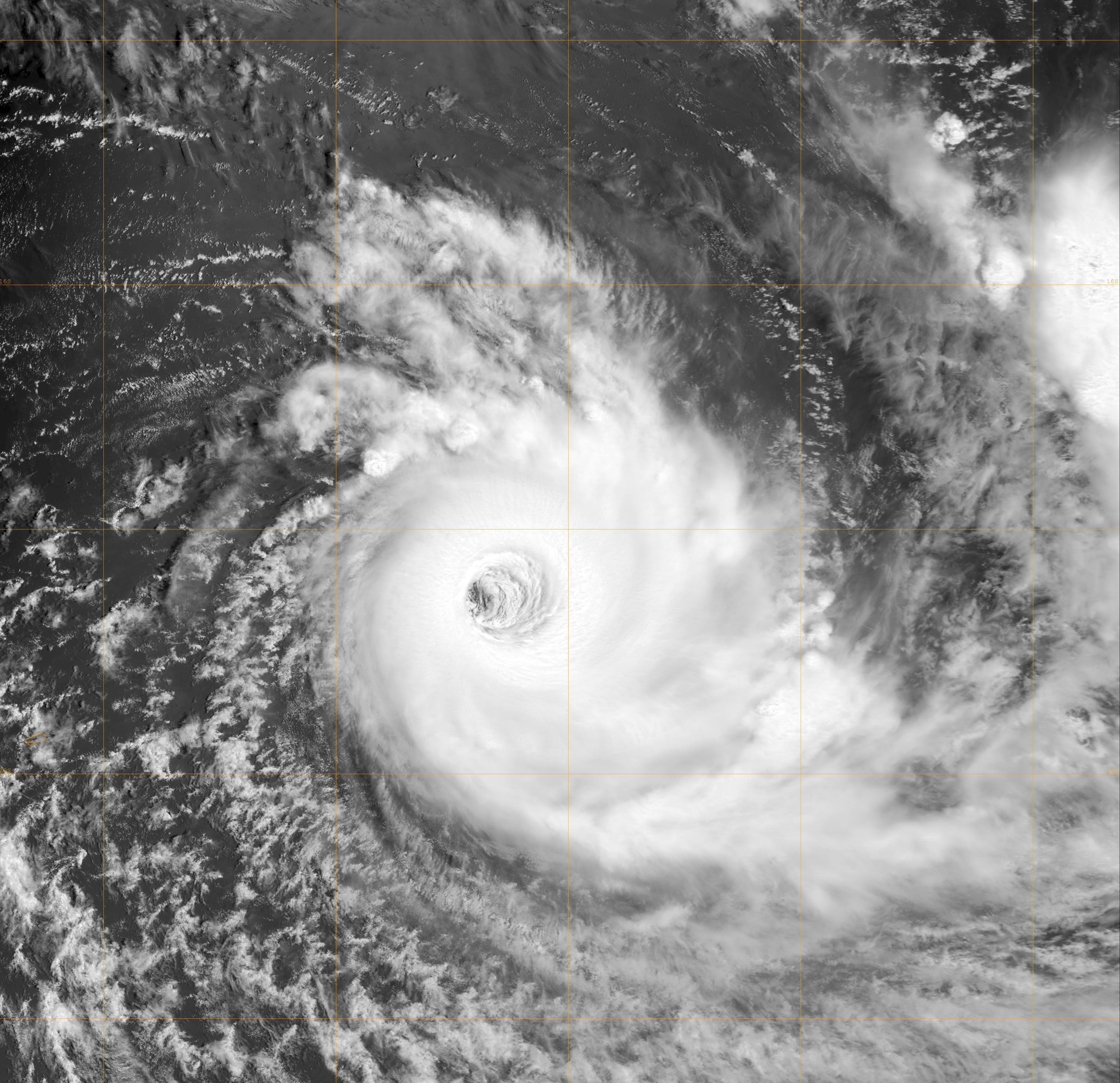
Duration December 15 – December 28 Intensity 205 km/h (125 mph) (10-min), 930 mbar (hPa) Main article: Cyclone BondoAn area of convection was first spotted on December 15 west-southwest of Diego Garcia. Moving west, it gained some organisation, causing the JTWC to issue a TCFA on it. It was designated a tropical disturbance on December 17 by Météo-France. The JTWC upgraded it to a tropical cyclone on December 18, and later that day Météo-France upgraded the storm to a moderate tropical storm. The Subregional Tropical Cyclone Advisory Centre in Mauritius named the storm Bondo, a name contributed to the list by Malawi.[2] Following a quick bout of intensification, on December 19 MF reported that Bondo had strengthened into a severe tropical storm. At the next advisory, MF reported that Bondo had undergone rapid intensification, breaking Dvorak rules, and upgraded it to tropical cyclone intensity. The JTWC noted that the tropical cyclone had "intensified at a greater than climatological rate" due to good radial outflow as it upgraded the storm from an equivalent of a strong tropical storm at 0300 UTC December 19 to a Category 3-equivalent at 1500 UTC. Further strengthening that day saw Bondo upgraded to an intense tropical cyclone, peaking at 110 knots (200 km/h) and 930 hPa. After going through an eyewall replacement cycle, the storm began to weaken. Continuing to track south-southwestward as it weakened, it crossed an area of lower vertical wind shear and began to restrengthen near the northern tip of Madagascar on December 23. Moving south-southwest parallel to the coast of Madagascar, it reached a secondary peak of 75 knots (139 km/h) from Météo-France before starting to weaken as it was about to make landfall. It made landfall around 1215 UTC, and the JTWC declared the storm dissipating over land at 1800 UTC, while Météo-France designated the storm as an inland depression. On December 26 M-F reported that the original low associated with Bondo had dissipated and a new low had formed associated with the system over sea. The RSMC La Reunion stopped issuing advisories later that day.
In response to the danger from Bondo, the Farquhar Atoll, which is part of the Seychelles, evacuated 35 of its 43 residents. The remaining eight stayed on the island in a concrete bunker.[3] The island of Agalega received at least 11 inches of rain from Bondo.[4] Eleven people were killed as a result of Bondo and another was reported as missing. A total of 20,001 people were left homeless.[5]
Tropical Disturbance 04
Tropical disturbance (MFR) Duration December 22 – December 28 Intensity 35 km/h (25 mph) (10-min), Unknown An area of persistent convection first developed on December 22 northwest of Diego Garcia. Mauritius designated it a tropical disturbance in their high seas warning for 0000 UTC December 25, and later that day Météo-France Réunion designated it Zone perturbée 04R. The next day, it gained enough organisation to be designated a tropical disturbance as it headed towards Madagascar. On December 28 RSMC La Reunion downgraded the storm to a zone of disturbed weather and terminated the regular advisories.
Severe Tropical Storm Clovis
Severe tropical storm (MFR) Category 1 tropical cyclone (SSHS) 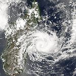

Duration December 29 – January 4 Intensity 115 km/h (70 mph) (10-min), 978 mbar (hPa) On December 29, Météo-France (M-F) began issuing irregular bulletins on a new zone of disturbed weather, east-southeast of the final position of 04R. The Joint Typhoon Warning Center had earlier issued a Tropical Cyclone Formation Alert on December 27, although M-F stated on December 29 that the low level circulation centre (LLCC) of 04R had dissipated. After several short-lived LLCCs overnight, a new cyclonic circulation had organised around the centre of the system, justifying the renumbering. On December 30 the system became more organized and was designated a tropical disturbance. At 1200 UTC on December 31, 05R was upgraded to Moderate Tropical Storm Clovis. The name Clovis was contributed by Mauritius.[2] At 1500 UTC on the same day, RSMC La Reunion reported that Clovis had winds of 50 kt (93 km/h) with a minimum pressure of 987 hPa, and upgraded it to Severe Tropical Storm Clovis. Clovis passed 20 km northwest of Tromelin Island at approximately 1700 UTC on December 31 with winds of 54 kt (100 km/h), gusting to 70 kt (130 km/h). It made landfall once on January 3, and dissipated on January 4. Four people were killed and two others were left missing as a result of Clovis. A total of 13,465 people were left homeless.[5]
Tropical Disturbance 06
Tropical disturbance (MFR) Duration January 5 – January 8 Intensity 35 km/h (25 mph) (10-min), Unknown On January 5, a cluster of clouds was spotted near the western coast of Madagascar by the U.S. Navy. By January 8, according to Météo-France, it had developed into a tropical disturbance, the 6th of the season. Later that day, MF ceased issuing advisories with no further development expected.
Intense Tropical Cyclone Dora
Intense tropical cyclone (MFR) Category 4 tropical cyclone (SSHS) 

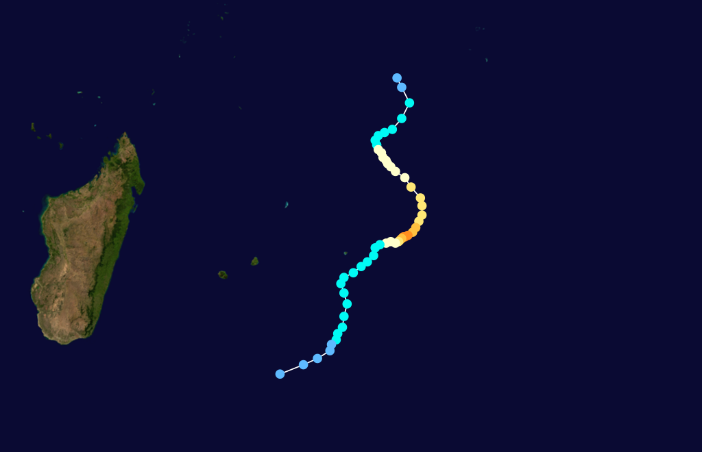
Duration January 26 – February 13 Intensity 195 km/h (120 mph) (10-min), 925 mbar (hPa) On January 28, an area of disturbed weather west of Diego Garcia was designated as a tropical disturbance by Météo-France. The Joint Typhoon Warning Center initiated advisories on Tropical Cyclone 10S later that day, shortly after it released a Tropical Cyclone Formation Alert. The system was upgraded to a tropical depression on January 29, and later that day to a moderate tropical storm by M-F. It was named Dora, which was contributed to the namelist by Mozambique.[2] Dora meandered southward over the next two days while strengthening, and Météo-France upgraded it to a tropical cyclone early on February 1. Although forecast to weaken, Dora continued to strengthen against expectations before weakening slightly. The storm then became annular and intensified further, peaking at 100 kt, 930 hPa on February 3. It then started to weaken as it curved to the southwest, and became fully extratropical on February 9. M-F last noted the extratropical system late on February 12.
Dora caused a Class 2 cyclone warning on Rodrigues island, but no deaths or damage has been reported.
Severe Tropical Storm Enok
Severe tropical storm (MFR) Tropical storm (SSHS) 

Duration February 6 – February 13 Intensity 110 km/h (70 mph) (10-min), 978 mbar (hPa) On February 7, the Joint Typhoon Warning Center issued a Tropical Cyclone Formation Alert on an area of convection east of the coast of Madagascar. Météo-France designated it a tropical disturbance, the 8th of the season, late the next day. On February 9, the JTWC upgraded the disturbance to a tropical cyclone, numbering it 13S, shortly before M-F upgraded it to a tropical depression. The system was named Enok by Madagascar later that day, despite Météo-France not upgrading it to a moderate tropical storm. The name Enok was contributed by Namibia.[2] The system was upgraded to a severe tropical storm at the next advisory, but slowly began to weaken the next day. When passing near Rodrigues, Enok caused a Class 4 cyclone warning, before the storm was downgraded to a tempête tropicale moderée on February 10. The JTWC issued its final warning on Enok the next day, before the storm was further downgraded to a tropical depression by M-F later that day. It was last mentioned six hours later after it was downgraded to a tropical disturbance.
Intense Tropical Cyclone Favio
Intense tropical cyclone (MFR) Category 4 tropical cyclone (SSHS) 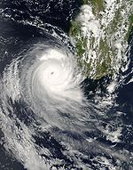
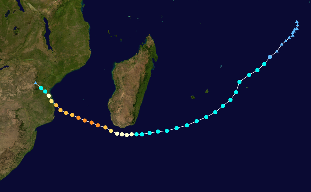
Duration February 11 – February 23 Intensity 195 km/h (120 mph) (10-min), 925 mbar (hPa) Main article: 2007 Mozambican floodEarly on February 12, Météo-France noted an area of convection, designating it 09R, and it was upgraded to a disturbance twelve hours later. Late on February 13, the Joint Typhoon Warning Center issued a TCFA on the disturbance, and upgraded it to Tropical Cyclone 14S the next day. On February 15, M-F upgraded the system to a moderate tropical storm, and it was named Favio, a name contributed by the Seychelles.[2] A vigilance cyclonique (cyclone watch)/yellow alert was issued later that day, and three-hourly updates were commenced due to the threat to La Réunion. This was discontinued on February 16 after Favio moved well to the south of the island. The storm further intensified early on February 18 and was upgraded to a severe tropical storm. It continued to strengthen, and was upgraded to a tropical cyclone at 10 a.m. local time on February 19. The small tropical cyclone reached intense tropical cyclone status the next day, peaking at 105 kt, 925 hPa. It then tracked west-northwestward, threatening Mozambique and forcing the authorities to put the country on the highest level of alert.[6] The British Foreign Office also issued a travel warning to Britons planning visits to or on the islands of the Bazaruto Archipelago.[7] It made landfall on February 22 in Inhambane Province as an intense tropical cyclone, exactly seven years to the day since the last intense tropical cyclone, Eline, struck Mozambique.[8] Once inland, it weakened quickly to below cyclone status with 30-knot (56 km/h) average winds over 10 hours after landfall.
Favio damaged the town court and town prison in the resort town of Vilanculos in Mozambique. Uprooted trees caused by the cyclone also blocked roads, cutting off access for rescuers to some homes.[9] The cyclone killed four people and injured at least seventy in the town, and thousands of homes were destroyed along with the hospital and power grid. 120 patients were evacuated from the rural hospital and 600 prisoners escaped when the local jail was demolished. Bazaruto Island, only reachable by boats and helicopters, was cut off from communications as the electricity grid was destroyed. The storm also unearthed trees and blew off rooftops in Pontagea, a highly populated suburb in the port city of Beira.[10] A total of ten people were killed by the storm and nearly 100 others were injured,[11] and the storm caused $71 million USD in damage.
The remnants of the system caused authorities in Zimbabwe to issue a flood warning.[12] In the aftermath of the storm, South Africa offered helicopters to Mozambique to deliver food to shelters and to help Mozambican officials assess the situation aerially.[13]
Intense Tropical Cyclone Gamede
Intense tropical cyclone (MFR) Category 3 tropical cyclone (SSHS) 

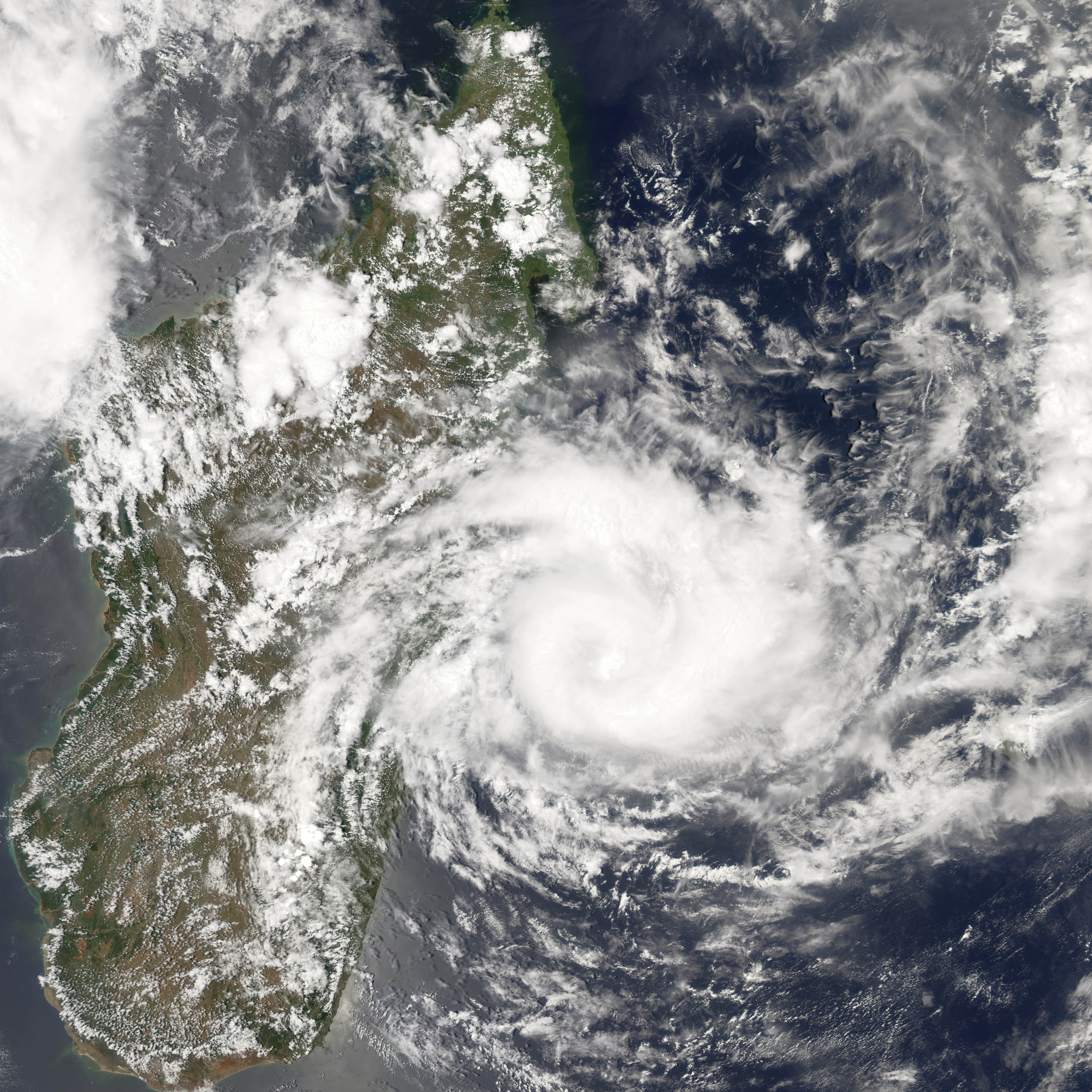
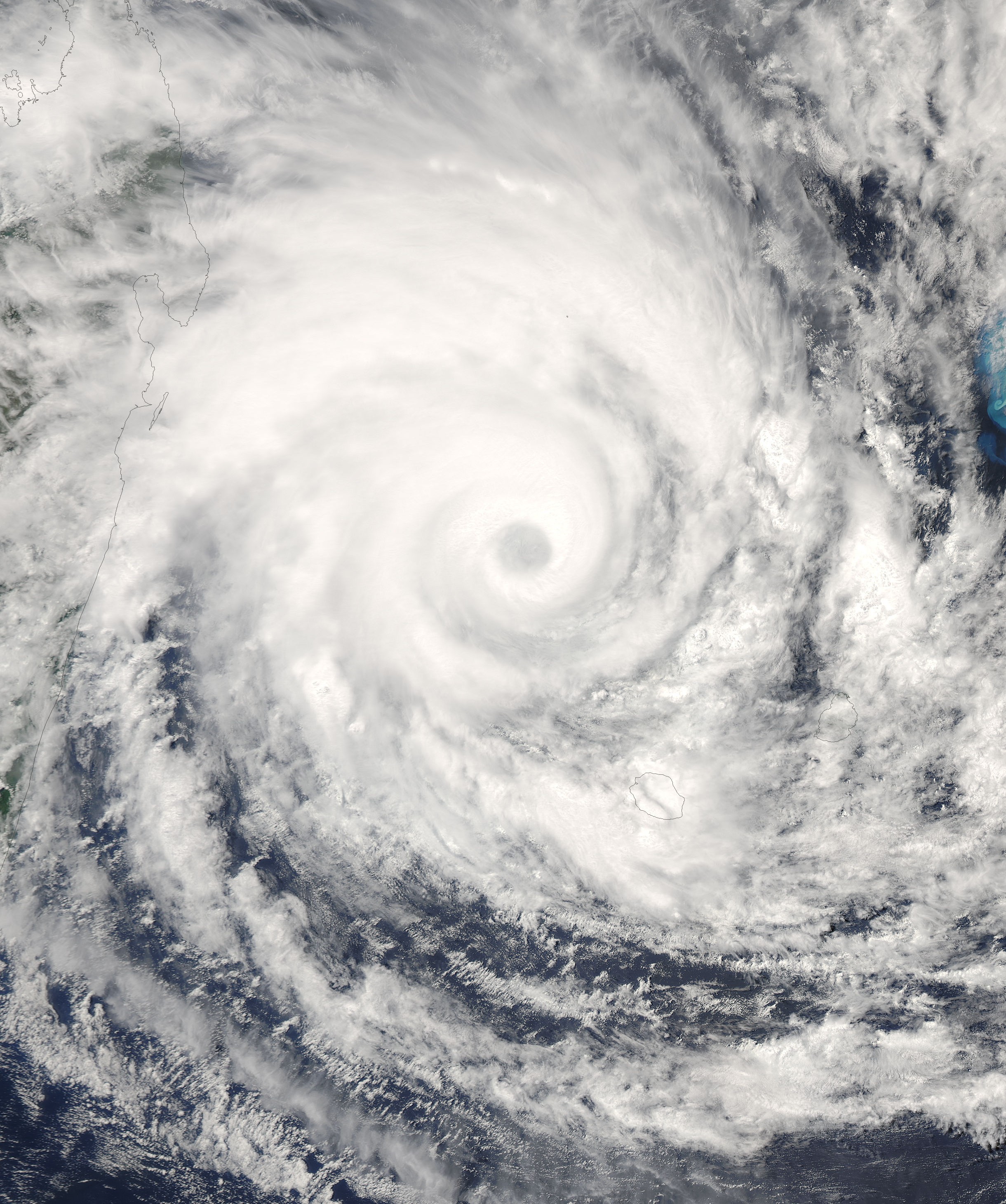
Duration February 19 – March 6 Intensity 165 km/h (105 mph) (10-min), 935 mbar (hPa) Main article: Cyclone GamedeMétéo-France began advisories on a tropical disturbance well south-southeast of Diego Garcia on February 20. It was quickly upgraded to a tropical depression later that day, and the next day it was named Gamede after attaining tropical storm status. TGamede strengthened into a severe tropical storm the next day as it moved westwards, causing the Mauritius Meteorological Services to issue a class 1 cyclone warning for the island. This was upgraded to a class 2 warning as Gamede strengthened into a tropical cyclone on February 23. The system, which at one point had a 500 km (310 mi)- 30 knots (56 km/h) wind field, continued to strengthen as it moved westsouthwest, causing officials on Réunion to issue a yellow alert/vigilance cyclonique that same day. Mauritius further raised the cyclone warning to class 3 as the island came near to the 30 knots (56 km/h) wind field of the large system. On February 24, as the storm grew larger in size, the yellow alert for Réunion was upgraded to an orange alert, the first of the season. Later that day the first red alert of the season for the island came into force. Mauritius raised the cyclone warning to a class 4 early on February 25 because of gusts associated with Gamede above 120 km/h around the island, but terminated bulletins later that day as the storm continued to move farther away from the island. After a slight weakening due to dry air, and a re-organisation of convection near the centre of the system, Gamede strengthened into an intense tropical cyclone.
Early on February 26 M-F discontinued the red alert for Réunion and declared the post-cyclone phase de prudence, which means that dangers still exist despite the cyclone no longer being a threat.[14] Later that day, Madagascar issued an advisory of imminent danger for 13 areas. On February 27, M-F reinstated an orange alert for Réunion as the system underwent an eyewall replacement cycle and grew in size. This was re-upgraded to a red alert that evening as the cyclone neared the island again. French Overseas Minister François Baroin arrived on the island earlier that day to assess damage, and said he would stay through the red alert. A bridge that collapsed due to Gamede caused about €20 million in damage.[15] The red alert was discontinued and replaced by the phase de prudence advisory early on February 28. M-F declared the all-clear later that day. Gamede moved further southwards between Réunion and Madagascar while still retaining tropical cyclone intensity, but started to weaken, and on March 1 it was downgraded to a severe tropical storm. It then started undergoing extratropical transition, with the centre of the storm becoming exposed. The JTWC issued its final warning on March 2, and M-F followed suit later that day.
Gamede broke numerous world records for tropical cyclone rainfall, with world records set for accumulated rainfall over 72 hours to accumulated rainfall over 9 days.[16] Between February 24 and 27 , 154.6 inches (3929 mm) of rain fell on Réunion island.[17]
Tropical Cyclone Humba
Tropical cyclone (MFR) Category 1 tropical cyclone (SSHS) 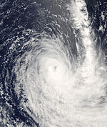

Duration February 20 – March 4 Intensity 140 km/h (85 mph) (10-min), 960 mbar (hPa) A tropical low southwest of Sumatra was first referenced in a BOM three-day cyclone outlook on February 19. Two days later, while slowly developing, it crossed 90°E and was designated Tropical Disturbance 11R by M-F. The JTWC issued a TCFA on February 21, and upgraded it to Tropical Cyclone 16S several hours later as convection continued to flare. It was upgraded by M-F to a tropical depression the next day. Little strengthening occurred over the next two days, although convection continued to be impressive. It was upgraded to a moderate tropical storm on February 23, and was named Humba, the name submitted by Tanzania.[2] Gradual strengthening continued, and Humba was upgraded first to a severe tropical storm later that day then to a tropical cyclone on February 25. It managed to strengthen to 80 kt, 960 hPa, before it started weakening again, and was downgraded back to a severe tropical storm on February 26. The same day, with Humba undergoing extratropical transition, the JTWC issued its final warning on the system. Météo-France followed suit the next day.
Intense Tropical Cyclone Indlala
Intense tropical cyclone (MFR) Category 4 tropical cyclone (SSHS) 

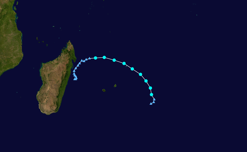
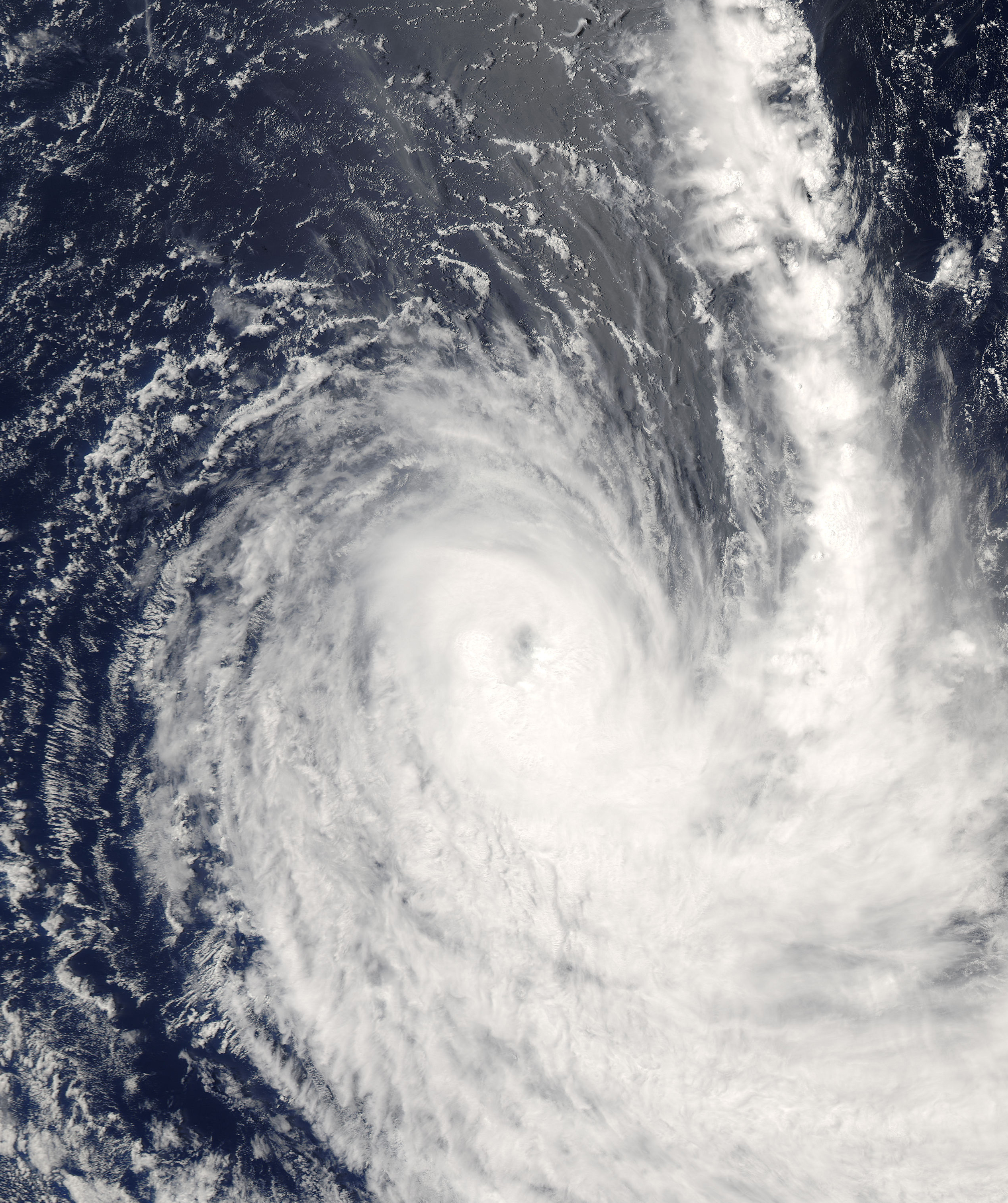
Duration March 9 – March 19 Intensity 175 km/h (110 mph) (10-min), 935 mbar (hPa) Main article: Cyclone IndlalaOn March 10, Météo-France noted an area of convection around 60°E, and numbered it 12R. The next day, M-F upgraded it to a tropical disturbance as the Joint Typhoon Warning Center issued a Tropical Cyclone Formation Alert on it. The disturbance continued to strengthen, and later that day M-F upgraded 12R to a tropical depression. Under favorable conditions, it strengthened into a moderate tropical storm early on March 12. Originally, the storm was referred to as "Indlada" by M-F, but this was later corrected to the correct name, Indlala, which was contributed by Swaziland.[2] Indlala continued to strengthen, and it was upgraded to a severe tropical storm. It reached tropical cyclone intensity on March 13 in favourable conditions, with infrared satellite imagery showing an intermittent eye. It continued to strengthen in a favourable environment, with a well-defined eye, and reached intense tropical cyclone strength the next day as it tracked westward towards Madagascar. It made landfall early on March 15 as it was undergoing an eyewall replacement cycle, near Antalaha, Madagascar, and weakened quickly while over land. It dissipated over land on March 17, and the final warning was issued.
Indlala killed 150 people and left another 126 missing. A total of 188,331 people were also left homeless due to the storm.[5] Damages from Indlala amounted to $240 million.
Tropical Disturbance 13
Tropical disturbance (MFR) Duration March 13 – March 17 Intensity 35 km/h (25 mph) (10-min), Unknown Tropical cyclone bulletins were initiated by Météo-France on March 13 on an area of disturbed weather that had lingered in the south central Indian Ocean for three days as satellite imagery showed an improving low-level circulation. Only irregular bulletins were issued over the course of the system's existence. It gained enough organisation to be considered a tropical disturbance on March 15, but never strengthened further. The final warning was issued on March 17 as it started to dissipate.
Intense Tropical Cyclone Jaya
Intense tropical cyclone (MFR) Category 3 tropical cyclone (SSHS) 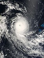

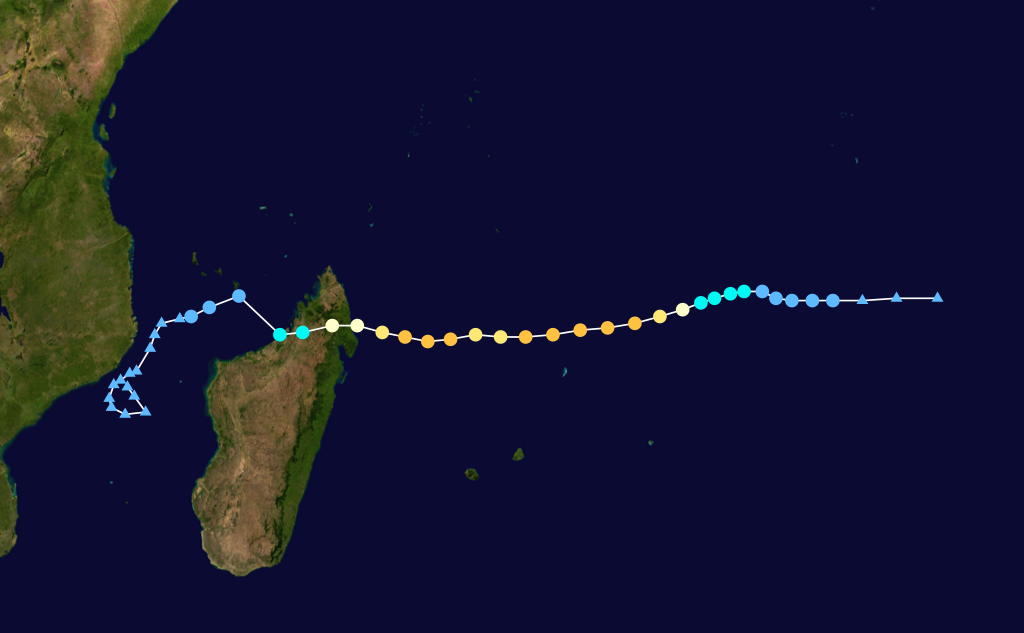
Duration March 26 – April 8 Intensity 185 km/h (115 mph) (10-min), 935 mbar (hPa) An area of sheared convection was first spotted on March 25 in the south central Indian Ocean. Four days later, Météo-France initiated warnings on the zone of disturbed weather, which had a partially-exposed low-level centre. At first, only irregular bulletins were issued, but as it organised rapidly it was upgraded to a tropical depression on March 30. Mauritius designated the system a moderate tropical storm at the same time, and named it Jaya, a name contributed by Zimbabwe.[2] The Joint Typhoon Warning Center issued a TCFA, before designating it Tropical Cyclone 22S later that same day. As it continued to organise, M-F upgraded it to a moderate tropical storm. It continued to strengthen, and Jaya was upgraded to a tropical cyclone early on March 31 by M-F. Rapid intensification continued, and Jaya quickly reached intense tropical cyclone status by the afternoon of the 31st, reaching a peak of 100 kt 930 hPa.
However, its small size meant that its structure and intensity easily fluctuated, and on April 1 it weakened slightly, with infrared imagery showing disorganisation as it encountered increased vertical wind shear, Jaya was downgraded to a tropical cyclone. As Jaya neared northeast Madagascar late on April 2, it was re-upgraded to an intense tropical cyclone after convection improved. However, Jaya lost strength just hours later as it was about to make landfall due to dry air and wind shear, and became disorganised.[18]
Jaya made landfall at around 0800 UTC April 3 near Sambava, Madagascar at tropical cyclone intensity, with wind gusts near 180–200 km/h.[19] It re-emerged over water in the Mozambique Channel as a highly-disorganised weak system lacking convection, and the final warning was issued.
On April 5, deep convection consolidated around the centre of Jaya's remnant circulation as the system reorganised, causing the JTWC to issue a new TCFA. Météo-France issued an advisory at 1200 UTC that afternoon on Tropical Disturbance 14R, but noted that vertical wind shear limited potential for significant intensification. Due to its proximity to the Mozambique coast, the system was affected by its terrain, but tracked just off the coast without making landfall. Over the next two days, Jaya came under heavy wind shear, and weakened considerably. However, it made another comeback on April 7, undergoing short-term rapid intensification, prompting Météo-France to issue a new advisory. However, convection became very weak and Jaya's circulation became fully exposed, and Météo-France again stopped advisories.
Reuters reports at least three people dead and many homes destroyed [1]. Several plantations were also ruined.
Subtropical Storm 15
Subtropical storm (SSHS) 

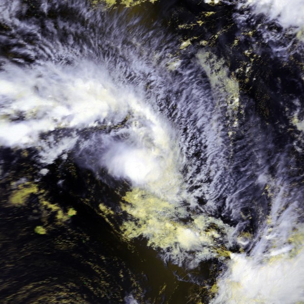
Duration April 9 – April 13 Intensity 95 km/h (60 mph) (10-min), 994 mbar (hPa) On April 11, Météo-France started warnings on a subtropical system to the south of Madagascar. It was water with a sea surface temperature of 25 °C, and had weak convection associated with it. The warning noted that due to a decrease in wind shear, the system had organised enough to be considered a subtropical depression. However, in the warning it was also noted that extratropical transition would soon occur. It became fully extratropical the next day after wind shear increased. In operational reanalysis, it was found that the system had formed on April 9, and had become a tropical depression late on April 10 before becoming subtropical and reaching gale strength.[20]
Storm names
A tropical disturbance is named when it reaches moderate tropical storm strength. If a tropical disturbance reaches moderate tropical storm status west of 55°E, then the Sub-regional Tropical Cyclone Advisory Centre in Madagascar assigns the appropriate name to the storm. If a tropical disturbance reaches moderate tropical storm status between 55°E and 90°E, then the Sub-regional Tropical Cyclone Advisory Centre in Mauritius assigns the appropriate name to the storm. A new annual list is used every year so no names are retired.[21] These were the names used this year.[22]
- Jaya
- Katse (unused)
- Lisebo (unused)
- Magoma (unused)
- Newa (unused)
- Olipa (unused)
- Panda (unused)
- Quince (unused)
- Rabeca (unused)
- Shyra (unused)
- Tsholo (unused)
- Unokubi (unused)
- Vuyane (unused)
- Warura (unused)
- Xylo (unused)
- Yone (unused)
- Zouleha (unused)
Season effects
This table lists all the storms that developed in the Southern Hemisphere during the 2006-2007 South-West Indian Ocean cyclone season. It includes their intensity, duration, name, landfalls, deaths, and damages. All data is taken from Météo-France. Number in parenthesis are people missing.
2006-07 South-West Indian cyclone statistics Storm name Active dates Storm category at peak intensity
Max wind
(mph)
Min. press.
(mbar)
Landfall(s) Damage (millions
USD)
Deaths Where When Wind (mph)
01 October 19 – October 23 Tropical disturbance 25 Unk. none none 0 Anita November 26 – December 4 Moderate tropical storm 40 996 none none 0 Bondo December 15 – December 28 Intense tropical cyclone 125 930 Antsiranana, Madagascar December 23 85 Unknown 11 (1) Mahajanga, Madagascar December 25 75 04 December 22 – December 28 Tropical disturbance 25 Unk. none none 0 Clovis December 29 – January 4 Severe tropical storm 70 978 Vatomandry, Madagascar January 3 65 Unknown 4 (2) 06 January 5 – January 8 Tropical disturbance 25 Unk. none none 0 Dora January 26 – February 13 Intense tropical cyclone 120 925 none none 0 Enok February 6 – February 13 Severe tropical storm 70 978 none none 0 Favio February 11 – February 23 Intense tropical cyclone 120 925 Inhambane Province, Mozambique February 22 110 71 10 Gamede February 20 – March 3 Intense tropical cyclone 105 925 Mascarene Islands (Direct hit, no landfall) February 23-28 105 26 4 Humba February 20 – March 4 Tropical cyclone 85 960 none none 0 Indlala March 9 – March 19 Intense tropical cyclone 110 935 Antalaha, Madagascar March 15 110 240 150 (126) 13 March 13 – March 17 Tropical disturbance 25 Unk. none none 0 Jaya March 26 – April 8 Intense tropical cyclone 115 935 Sambava, Madagascar April 3 85 Unknown 3 15 April 9 – April 13 Subtropical storm 60 994 none none 0 Season Aggregates 15 Disturbances October 19 – April 13 130 915 5 landfalls 337 172 (129) See also
- Tropical cyclone scales
- List of Southern Hemisphere tropical cyclone seasons
- Atlantic hurricane seasons: 2006, 2007
- Pacific hurricane seasons: 2006, 2007
- Pacific typhoon seasons: 2006, 2007
- North Indian Ocean cyclone seasons: 2006, 2007
References
- ^ a b c d WebCite query result
- ^ a b c d e f g h i http://www.wmo.ch/web/www/TCP/OperationPlans/TCP-12%2520Edition%25202006-English.pdf (PDF 461k)
- ^ http://www.alertnet.org/thenews/newsdesk/L21751807.htm
- ^ Tropical Cyclone Bondo approaches North Madagascar
- ^ a b c Tropical Cyclone Committee (September 5, 2008). "Madagascar: Review of the 2005/2006, 2006/2007 and 2007/2008 Cyclone Seasons". World Meteorological Organization. http://www.wmo.ch/pages/prog/www/tcp/Meetings/documents/d04-2_3_en.doc. Retrieved February 15, 2009.
- ^ "Fear as cyclone nears Mozambique". BBC News. February 21, 2007. http://news.bbc.co.uk/2/hi/africa/6383675.stm. Retrieved April 22, 2010.
- ^ "Warning to Mozambique travellers". BBC News. February 22, 2007. http://news.bbc.co.uk/2/hi/uk_news/6384811.stm. Retrieved April 22, 2010.
- ^ Communique
- ^ "Cyclone Favio strikes Mozambique". BBC News. February 23, 2007. http://news.bbc.co.uk/2/hi/africa/6385405.stm. Retrieved April 22, 2010.
- ^ http://www.alertnet.org/thenews/newsdesk/L2391711.htm
- ^ SAPA (March 11, 2007). "Cyclone may hit tourist resorts". News24. http://www.news24.com/News24/Africa/News/0,,2-11-1447_2285849,00.html. Retrieved April 4, 2009.
- ^ "Zimbabwe in storm flood warning". BBC News. February 23, 2007. http://news.bbc.co.uk/1/hi/world/africa/6389243.stm. Retrieved April 22, 2010.
- ^ "SA offers Mozambique assistance". BBC News. February 24, 2007. http://news.bbc.co.uk/2/hi/africa/6392959.stm. Retrieved April 22, 2010.
- ^ tableau-des-alertes
- ^ Cyclone nears coastline of Reunion Island; 1 woman reported missing - International Herald Tribune
- ^ WebCite query result
- ^ Faq : Hurricanes, Typhoons, And Tropical Cyclones
- ^ WebCite query result
- ^ WebCite query result
- ^ WebCite query result
- ^ "Tropical Cyclone Operational Plan for the South Pacific and South-East Indian Ocean". World Meteorological Organization. 2003. http://ftp.wmo.int/pages/prog/www/TCP_vO/OperationPlans/TCP12-English2003.pdf. Retrieved 2008-08-15.
- ^ La Réunion - Météo-France (2007). "Liste des noms des tempêtes et cyclones tropicaux pour la saison 2006-2007 sur le Sud-Ouest de l´Océan Indien" (in French). http://www.meteo.fr/temps/domtom/La_Reunion/TGPR/saison20062007/Liste_NomsBapteme.html. Retrieved 2008-01-31.
External links
- Joint Typhoon Warning Center (JTWC).
- Météo France (RSMC La Réunion).
- World Meteorological Organization
2000–09 South-West Indian Ocean cyclone seasons Categories:


Wikimedia Foundation. 2010.