- Antananarivo
Infobox Settlement
official_name = Antananarivo
other_name = Tananarive
native_name =
nickname = Tana
motto =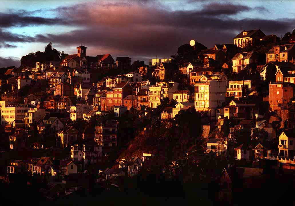
imagesize = 240px
image_caption = Antananarivo at sunset, March 2005
flag_size =
image_
seal_size =
image_shield =
shield_size =
mapsize = 200px
map_caption = Location of Antananarivo in Madagascar
subdivision_type = Country
subdivision_name =Madagascar
government_type =
leader_title =
leader_name =
leader_title1 =
leader_name1 =
leader_title2 =
leader_name2 =
leader_title3 =
leader_name3 =
established_title = Founded
established_date = 1625
area_magnitude =
unit_pref =
area_footnotes =
area_total_km2 =
area_land_km2 =
area_water_km2 =
area_total_sq_mi =
area_land_sq_mi =
area_water_sq_mi =
area_water_percent =
population_as_of = 2001 census
population_note =
settlement_type =
population_total = 1403449
population_density_km2 =
population_density_sq_mi =
timezone = East African Time (GMT+3)
utc_offset =
timezone_DST =
utc_offset_DST =
latd= |latm= |lats= |latNS=
longd= |longm= |longs= |longEW=
elevation_footnotes =
elevation_m = 1276
elevation_ft =
elevation_max_m =
elevation_max_ft =
elevation_min_m =
elevation_min_ft =Antananarivo (pronEng|ˌtəˌnænəˈriːv or IPA|/ˌtəˌnɑːnəˈriːv/) is the
capital and largest city inMadagascar . It is also known by its French name Tananarive or the colonial shorthand form Tana.The larger urban area surrounding the city, known as Antananarivo-Renivohitra ("Antananarivo-Capital"), is the capital of the
Analamanga region and of the Antananarivo autonomous province.Location
Antananarivo is situated in the center of the
island length-wise, and 145 km (90 miles) away from the eastern coast. The city occupies a commanding position, being built on the summit andslopes of a long and narrow rockyridge , which extends north and south for about convert|4|km|mi|0|abbr=on and rising at its highest point to about convert|200|m|ft|-1|abbr=on above the extensive rice plain to the west, although the town is at about convert|1275|m|ft|0|abbr=on above sea level. It is Madagascar's largestcity and is its administrative,communication s, andeconomic center. The city is located convert|215|km|mi|0|abbr=on west-southwest ofToamasina , the principalseaport of the island, with which it is connected byrailway , and for about convert|100|km|mi|-0|abbr=on along the coastallagoon s, a service of small hookers.Antananarivo is served by
Ivato Airport .History
Unlike most capital cities in
southern Africa , Antananarivo was already a major city before the colonial era. The city was founded circa 1625 by King Andrianjaka and takes its name (the City of the Thousand) from the number of soldiers assigned to guarding it. For many years it was the principalvillage of the Hova chiefs and gained importance as those chiefs made themselves sovereigns of the greater part ofMadagascar , eventually becoming atown of some 80,000 inhabitants. In 1793 it was made thecapital of theMerina kings. The conquests of KingRadama I made Antananarivo the capital of almost all ofMadagascar . Until 1869 all buildings within thecity proper were ofwood or rushes, but even then it possessed several timberpalace s of considerable size, the largest being convert|120|ft|m|0|abbr=on high. These crown the summit of the central portion of the ridge; and the largest palace, with its loftyroof andtower s, is the most conspicuous object from every point of view.Since the introduction of stone and
brick , the entire city has been rebuilt and now contains numerous European-style structures, including the royal palaces, the houses formerly belonging to theprime minister andnobles , the French residency, theAnglican andRoman Catholic cathedrals , and several stonechurches .Present day
The city was captured by the French in 1895 and incorporated into their Madagascar
protectorate . After the French conquest of Madagascar when the city had a population of some 100,000, it was extensively remodeled as the population grew to 175,000 by 1950. Roads were constructed throughout the city, broad flights of steps connecting places too steep for the formation of carriage roads, and the central space, called Andohalo, was enhanced with walks, terraces, flower-beds and trees. Water, previously obtained from springs at the foot of the hill, was brought from theIkopa River , which skirts the capital to the south and west.After independence in 1960 the pace of growth increased rapidly. The city's population reached 1.4 million by the end of the twentieth century.
Industries include food products,cigarette s, andtextiles .The city is guarded by two forts built on hills to the east and south-west. Including an Anglican and a Roman Catholic cathedral, there are about fifty churches in the city and its suburbs, as well as a
Muslim mosque . Antananarivo hosts a campus of theUniversity of Madagascar and the Collège Rural d'Ambatobe.Sister cities
*
Yerevan ,Armenia
*Suzhou ,China References
*
* [http://www.fallingrain.com/world/MA/5/Antananarivo.html FallingRain Map - elevation = 1288m (Red dots are railways)]Gallery
External links
* [http://www.antananarivo.mg/ Antananarivo Renivohitra] Official website.
Wikimedia Foundation. 2010.