- Deakin, Australian Capital Territory
-
Deakin
Canberra, Australian Capital Territory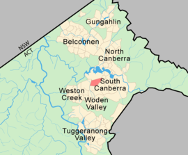
Population: 2,606 (2006 census)[1] • Density: 728/km² (1,885.5/sq mi) Established: 1928 Gazetted: 20 September 1928 Postcode: 2600 Area: 3.58 km² (1.4 sq mi) District: South Canberra Assembly Electorate: Molonglo Federal Division: Canberra Suburbs around Deakin: Stromlo Forest Yarralumla Capital Hill Curtin Deakin Forrest Hughes Garran Red Hill Deakin (postcode: 2600) is a suburb of Canberra, Australian Capital Territory, Australia. Deakin is named after Alfred Deakin, second prime minister of Australia. Streets in Deakin are named after Governors, Governors-General and diplomats.[2]
The official residence of the Prime Minister, The Lodge is located in Deakin.
Contents
Demographics
On Census night 2006, Deakin had a population of 2606 people.[1]
According to the 2006 Census there were 77 males per 100 females in the suburb of Deakin.[3]
Suburb amenities
A local shopping centre is located on Hopetoun Circuit and contains an IGA supermarket, service station, newsagent, chemist, and restaurants. The Deakin Health Spa, adjacent to the shops, has recently been taken over and rebadged as the local Fitness First facility. The Embassy Hotel/Motel was also adjacent to the shops, but has since been demolished.
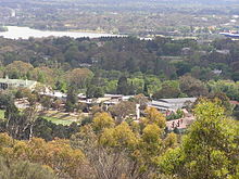 The suburb from Red Hill looking across the Girls' Grammar School to Yarralumla and Lake Burley Griffin
Schools in the suburb of Deakin include Alfred Deakin High School (originally Deakin High) and Canberra Girls' Grammar School.
Notable places
Embassies
Deakin contains the embassies of Afghanistan, Bosnia, Hungary and Italy and the high commissions of Brunei, Cyprus, Fiji, Mauritius and Solomon Islands.
The Lodge
Main article: The LodgeLocated on Adelaide Avenue the Lodge is the official residence of the Prime Minister of Australia.
The Royal Australian Mint
Main article: Royal Australian MintOfficially opened by the Duke of Edinburgh on 22 February 1965, the Royal Australian Mint was commissioned to produce Australia's decimal coinage, which came into effect on 14 February 1966.
Geology
The west of the suburb exposes Yarralumla Formation calcareous shale, sandstone, tuff and hornfels. The east of the suburb exposes Mount Painter Volcanics dark grey to green grey dacitic crystal tuff and agglomerate. A patch of cream rhyolite, tuff and ashstone is found in the mid east near empire circuit.
The Deakin Fault does not actually pass through Deakin. The Deakin Fault is a major fault in Canberra running North-west to south-east passing through state circle very close to Deakin. It extends from the hills to the east of Jerrabomberra via Narrabundah, Griffith, Forest, Yarralumla, then across the Molonglo River to Cook, then turns north east in Macquarie where it turns around to the north west again via Belconnen, Evatt, Melba, Flynn, Charnwood, Dunlop and out the north west of the ACT. It continues to the east end of Lake Burrunjuck near Yass. The block on the north east side was elevated and the south west side lowered.
The Deakin Anticline is a geological monument located between the Deakin Oval and the Grange Retirement Village. It is in the Yarralumla Formation in Tuffacious sandstone and siltstone. Access is from Hannah Place.
Embassies in Deakin  Afghanistan
 Bosnia and Herzegovina
 Brunei
 Cambodia
 Cyprus
 Fiji
Fiji Hungary
 Italy
Italy Mauritius
 Solomon Islands
References
- ^ a b Australian Bureau of Statistics (25 October 2007). "Deakin (State Suburb)". 2006 Census QuickStats. http://www.censusdata.abs.gov.au/ABSNavigation/prenav/LocationSearch?collection=Census&period=2006&areacode=SSC81111&producttype=QuickStats&breadcrumb=PL&action=401. Retrieved 2009-04-30.
- ^ "Suburb Name search results". ACT Planning & Land Authority. http://apps.actpla.act.gov.au/actlic/places/search/suburbResults_new3.asp?suburbName=DEAKIN&Submit=Continue. Retrieved 30 April 2009.[dead link]
- ^ "2914.0.55.002 - 2006 Census of Population and Housing: Media Releases and Fact Sheets, 2006". Auastralian Bureau of Statistics. Australian Government: ABS Australia. http://www.abs.gov.au/AUSSTATS/abs@.nsf/7d12b0f6763c78caca257061001cc588/7469858a551ffdb4ca257306000d563a!OpenDocument.
Categories:


Wikimedia Foundation. 2010.