- Mowbray Park
-
Mowbray Park 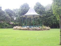
The bandstand in Mowbray ParkType Municipal Location Sunderland, England Coordinates 54°54′7″N 1°22′47″W / 54.90194°N 1.37972°W Created 1857 Operated by Sunderland City Council Status Open all year Mowbray Park is a municipal park in the centre of Sunderland, Tyne and Wear, England, located a few hundred yards from the busy throughfares of Holmeside and Fawcett Street and bordered by Sunderland Museum and Winter Gardens to the north, Burdon Road to the west, Toward Road to the east and Park Road to the south. The park was voted best in Britain in 2008.[1]
Contents
History
Mowbray Park is one of the oldest municipal parks in North East England.[2]
The roots of Mowbray Park date back to the 1830s, when a health inspector recommended building a leafy area in the town after Sunderland recorded the first cholera epidemic in 1831. A grant of £750 was provided by the Government to buy a £2,000 plot of land from the Mowbray family for a new park.
Work on Mowbray Park – then known as The People's Park – began in the mid-1850s, with a former limestone quarry being landscaped. Topsoil was placed over the spoil heaps and original footpaths were gravelled over – leading to the hummocks and winding paths of today.
The park was opened by John Candlish, Lord Mayor MP of Sunderland on 21 May 1857.
On the day of the park's opening on May 12, 1857, shops closed early as thousands of people flocked to attend the ceremony. An extension to Mowbray Park, from the railway cutting to Borough Road, was opened on July 11, 1866.
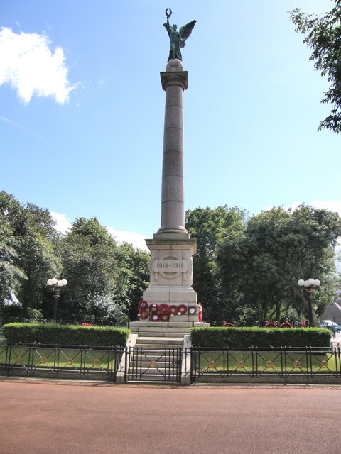
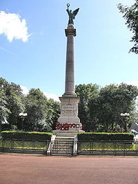 Sunderland War Memorial located just outside of the park
It was opened in 1857 in response to a demand for more open spaces in the town.[3] The land was purchased from the Mowbray family, and named after them in recognition. The park was extended in 1866 to include a lake and a terrace, and in 1879 the Winter Gardens, museum and art gallery were added along the Borough Road side.
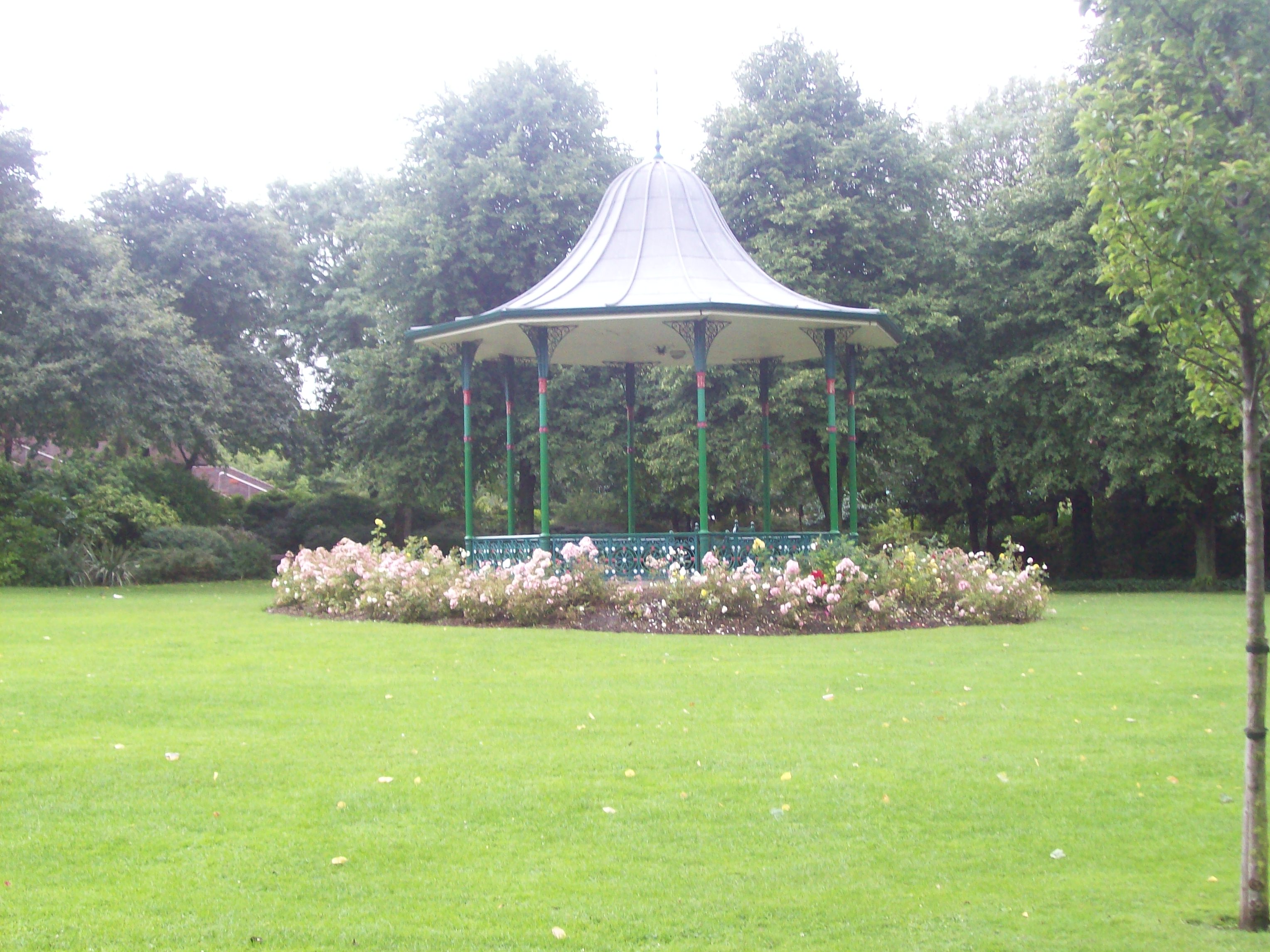
The Second World War had an impact on the park. It was hit with numerous German bombs, the iron structures - most notably the Winter Gardens, a cast iron bridge, and the bandstand - were taken away to be melted down for weapons, and the open spaces were converted into vegetable patches.
Following the war, the park fell into neglect. The civic centre was built on the west portion of the park. The area became known for anti-social and absuive behaviour, and was considered generally unsafe. In August 1993, over £13,000 worth of damage was caused, and a survey by the Sunderland Echo showed that locals were too scared to use the park.[4]
Following a public campaign, in 1994 work began on restoring the park to its Victorian glory, funded by a £4 million grant from the Heritage Lottery Fund,[2] described as: "The jewel in the crown of the city centre regeneration".[5] The Sunderland Museum and Winter Gardens were rebuilt, the lake was restored, the bandstand was rebuilt, and the park was re-shaped and adorned with numerous statues. A large adventure play area for children was built. The park officially re-opened in 2000.
In the first year following re-opening, the park received over 800,000 visitors, making it the most visited attraction outside of London.[5]
Structures
William Hall Drinking Fountain
The cast iron drinking fountain was constructed by Glenfield and Kennedy of Kilmarnock and erected in 1878 by the Manchester Unity of Oddfellows.[3][6] It is a memorial to William Hall, who was the oldest Oddfellow in the North of England when he died, aged 75, in 1876.[3] The domed canopy has eleborate foliage and four cupsed arches on the columns, which shelter the bollard-shaped drinking fountain.[6] Above each arch is an escutcheon and motto: on the north and south is "Keep the pavement dry" and "Nil desperandum auspice deo 1878" (the motto on the Coat of arms of Sunderland) with symbols of the Borough of Sunderland and of Oddfellows.;[6] on the east and west is "Amicitia Amor et Veritas" (the motto of Oddfellows), "In memory of Wm. Hall PPGM of the Sunderland District Independent Order of Oddfellows" and "Presented to the Corporation of Sunderland by the Oddfellows NU".[6] The fountain was repaired and restored with the re-opening of Mowbray Park in 2000.[6]
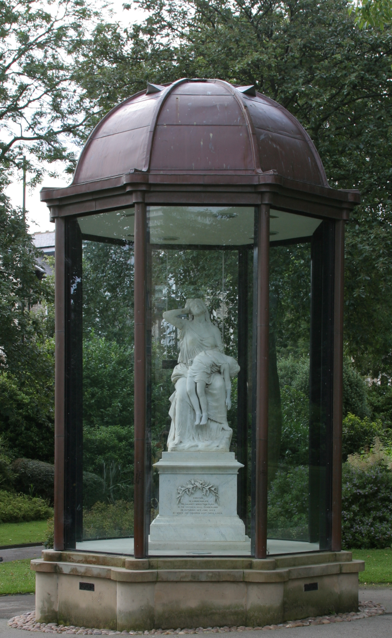
Victoria Hall disaster Memorial
Main article: Victoria Hall disasterMowbray Park was the original site of the memorial for the Victoria Hall disaster of 1883 in which 183 children were trampled to death in the Victoria Hall, which overlooked Mowbray Park. The marble statue of a mother holding her dead child was later moved to Bishopwearmouth Cemetery, but in 2002 it was restored and moved back to the park.
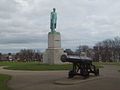
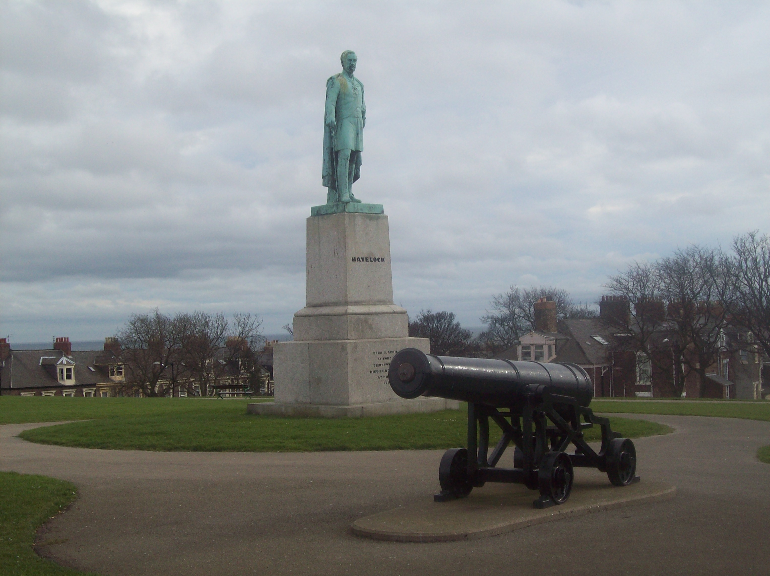
Statue of Henry Havelock
The Havelock statue, constructed in 1861, is located on Building Hill at the south of the park and commemorates Sir Henry Havelock, a celebrated military general born in Bishopwearmouth. Either side of the statue are cannons, named Joshua and Caleb, replicas of those captured from the Russians during the Crimean war.[7] The originals were melted down for metal during the Second World War.[7]
The over life-sized bronze figue of Havelock in military uniform and a sword in his hand is on a high stepped based and a tall, square, granite plinth and faces toward his birth place.[8] The figure is signed 1861 by Behnes and the founder's mark on the rear of plinth reads: "The Statue Foundry, Pimlico, London".[8] The inscription on the front of the plinth reads: "Born 5 April 1775 at Ford Hall, Bishopwearmouth. Died 24 November 1857 at Dil Koosha, Lucknow".[8] The statue was repaired and restored with the re-opening of Mowbray Park in 2000.[8]
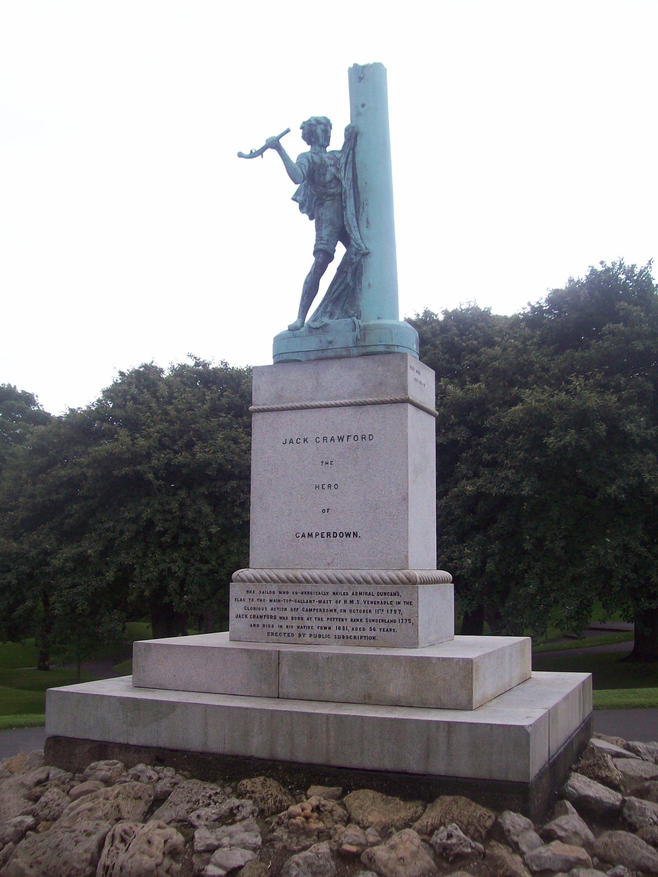
Statue of Jack Crawford
Jack Crawford, born in Sunderland, was honoured for bravery when he climbed the mast of his ship, the HMS Venerable, during the Battle of Camperdown to nail the British flag back up. Although he died a pauper (he was also the second victim of the cholera epidemic in Britain), a memorial statue was erected for him in 1890.
The monument is signed and dated "Percy Wood fecit 1889–90".[9] The life size, bronze figure of Crawford is on a granite plinth set on a mound of magnesian limestone.[9] Crawford is in seaman's dress nailing a flag to the mast, using a pistol butt as hammer.[9] The irregularly-piled pieces of limestone rock support the plinth which has an inscription on its north side: "The sailor who so heroically nailed Admiral Duncan's flag to the main-top-gallant-mast of HMS Venerable in the glorious action off Camperdown on October 11, 1797. Jack Crawford was born at the Pottery Bank, in Sunderland, 1775 and died in his native town in 1831 aged 56 years. Erected by public subscription."[9]
Statue of John Candlish
Roughly in the centre of the park, stands a statue of John Candlish, who was mayor and later Member of Parliament for Sunderland from 1866 to 1874.
The statue is signed and dated "C Bacon Sc London 1875", with the founder's mark "H Young & Co. Art Founders Pimlico".[10] The slightly larger than life size figure shows Candlish in contemporary dress on a square plinth with a moulded stepped base of polished porphyritic granite.[10] The inscription reads: "John Candlish M.P. Born 1815 Died 1874".[10]
Walrus
Sunderland has strong links with author Lewis Carroll - it is believed Carroll wrote, among other things, the poem The Walrus and the Carpenter in the town. To commemorate the link, a number of statues are located around the park - most notably a walrus sculpture by the lake.
-
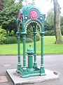
William Hall Drinking Fountain
-

Victoria Hall disaster Memorial
-
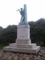
Statue of Jack Crawford
-
Statue of General Havelock
-

Statue of John Candlish
Events
Mowbray Park has become the site of annual christmas celebrations in the city, focused around a temporary ice rink.
External links
- BBC Wear – 360-degree panoramic view of Mowbray Park from the lake.
- BBC Wear – 360-degree panoramic view of Mowbray Park from the bandstand.
References
- ^ "Mowbray Park - Keep Britain Tidy Green Flag Award Sites". http://www.keepbritaintidy.org/GreenFlag/GreenFlagAwardSites/NorthEast/Default.aspx?parkID=190. Retrieved 16 July 2010.
- ^ a b "Mowbray Park - Architectural Tour". City of Sunderland Council. http://www.sunderland.gov.uk/public/editable/themes/environment/implementation/urban_design/architecturaltour/consprojects/mowbraypark.asp. Retrieved 2007-01-28.[dead link]
- ^ a b c "A brief history of Mowbray Park" (PDF). City of Sunderland Council. http://www.sunderland.gov.uk/libraries/Leaflets/Mowbray_Park.pdf. Retrieved 2007-01-28.[dead link]
- ^ "Mowbray Park". Improvement & Development Agency. http://www.makingendsmeet.idea.gov.uk/idk/core/page.do?pageId=1031814. Retrieved 2007-01-28.
- ^ a b "Mowbray Gardens" (PDF). Heritage Lottery Fund. http://www.hlf.org.uk/NR/rdonlyres/C1AC5891-7AC5-41C3-A152-C94527F9EEB3/464/MowbrayGardens1.pdf. Retrieved 2007-01-28.[dead link]
- ^ a b c d e "William Hall Drinking Fountain". Sunderland City Council. http://www.sunderland.gov.uk/apps/ListedBuildings/lbbuildingdetails.asp?Id=920-1/20/146&keyword=mowbray&Ownership=&Address3=&Grade=. Retrieved 2008-08-12.[dead link]
- ^ a b "Guns in Mowbray Park". North East War Memorials Project. http://www.newmp.org.uk/article.php?categoryid=100&articleid=1328. Retrieved 2008-08-22.
- ^ a b c d "Statue of General Havelock". Sunderland City Council. http://www.sunderland.gov.uk/apps/ListedBuildings/lbbuildingdetails.asp?Id=920-1/22/151&keyword=mowbray&Ownership=&Address3=&Grade=. Retrieved 2008-08-12.[dead link]
- ^ a b c d "Monument of Jack Crawford". Sunderland City Council. http://www.sunderland.gov.uk/apps/ListedBuildings/lbbuildingdetails.asp?Id=920-1/20/149&keyword=mowbray&Ownership=&Address3=&Grade=. Retrieved 2008-08-12.[dead link]
- ^ a b c "Statue of John Candlish MP". Sunderland City Council. http://www.sunderland.gov.uk/apps/ListedBuildings/lbbuildingdetails.asp?Id=920-1/20/147&keyword=mowbray&Ownership=&Address3=&Grade=. Retrieved 2008-08-12.[dead link]
Holy Trinity Church · Hylton Castle & Chapel · Phoenix Lodge · St Andrew's Church · St Peter's ChurchWashington Houghton-le-Spring Penshaw Monument · St Michael and All Angels ChurchDoxford House · Fulwell Acoustic Mirror · Fulwell Mill · Sunderland Minster · Monkwearmouth Station Museum · Old South Pier · Ryhope Pumping Station & Chimney · St George's Church · Empire Theatre · 11 Church Street EastHoughton-le-Spring City Centre Sunderland Museum · St Mary's Church · Mowbray Almshouses · Sunderland County Court · Corder House and Sydenham House · Elephant Tea Rooms · Green's Public House · The Isis · Sunderland Gas Board · Galen Building · Fitzgerald's Public House · Wearmouth Bridge · River Wear Commission Building · St Mary's Building · Wearmouth Rail Bridge · Sunderland Magistrates' Court · Sunderland and South Shields Water Company Building · Victoria Hall Disaster Memorial · Sunderland War Memorial · Burdon Road Masonic Temple · 4–25 Foyle Street · 28–40 and 43–48 West Sunnside · Medieval Arch & Wall · Central Buildings · Former General Post Office · Former Custom House · Maritime Buildings · 19, 20, 29 and 30 Villiers Street · West Park Church · 17–29, 32–42 & 45–58 Frederick Street · Mowbray Park (certain buildings) · Midland Bank · National Westminster Bank · Barclays Bank · Lloyds Bank · 11–17, 20–23 25–28 and 45–58 John Street · 2 & 3 Mary Street · 3–5 Albion Place · 19 & 31–33 Norfolk Street · 3 & 22 Athenaeum Street · Hutchinson's Buildings · The Londonderry · The Dun Cow · 1–7, 105–112, 114–118, 145, 170–173, 176, 211, 212 and 214–217 High Street West · 49–51 High Street East ·Monkwearmouth
and SouthwickMonkwearmouth Library · Monkwearmouth College · Wheatsheaf Hotel · North East Railway Stables · Holy Trinity Church · St Columba's Church · Hebron Church · 6 Back North Bridge Street · 57 and 58 Barclay Street · Southwick Limekilns · The Tramcar Inn · Thompson Memorial · Southwick War Memorial · 65–95 James Armitage Street · All Saints' ChurchRyhope
and BurdonRailway Inn · Ryhope Grange Farmhouse · St Paul's Church · The Chestnuts and The Wilderness · Burdon Hall · The Railway Inn · 14 Cliff Road · Ryhope War Memorial · Coqueda Hall · Ryhope Rent Office · Ryhope Pumping Station ·Ashbrooke
and ThornholmeBede Tower · Sunderland Synagogue · Christ Church · West Hendon House · St John's Church · Carlton House · Langham Tower · Ashburne House · The Crofts · Gray House · St George's House · 3–7 Douro Terrace · Valebrooke Gardens · Westburn House · 1–29 Thornhill Terrace · 1–15 Grange Crescent · 1–9 The Esplanade · Burdon House · 1–16 St Bede's Terrace · 1–24 Park Place East and West · Park Road Methodist Church ·Hendon
and GrangetownHendon Gas Works · Quayside Exchange · St Aidan's Church · Trafalgar Square Merchant Seaman's Almshouses · St Ignatius Church · Tavistock House · Sunderland East Community Centre · 10 Church Street East · Salisbury Street Steps · Sunderland Cemetery (certain buildings) · Former Methodist Manse · Bethesda Free Church · 17–23 Murton Street · 3–19 Ridley Terrace · North Dock (walls and mooring posts) · Hudson Dock (certain buildings) · Sunderland Harbour South Pier · Whylam Wharf · Bonded Warehouse ·Barnes
and HumbledonBarnes School · St Gabriel's Church · Kayll Road Library · Children's Hospital · Humbledon Pumping Station · Hill House · Bishopwearmouth Cemetery (certain buildings) · Barnes Park Bandstand ·Deptford, Millfield
and PallionThe Mountain Daisy Public House · St Joseph's Church · Queen Alexandra Bridge · St Mark's Church · St Luke's Church · Laing Fountain · Webster's RoperySilksworth
and TunstallSilksworth Hall · Tunstall Lodge · Silksworth Cottage · Tunstall School · Tunstall Hope Lodge ·North Hylton
and South HyltonFulwell, Roker
and Whitburn BentsFulwell Pumping Station · The Bents · Mere Knolls Cemetery (certain buildings) · Roker Park Bandstand · Roker Park Drinking Fountain · Roker Pier & Lighthouse · Andover · Fulwell Limekilns · 160, 162 & 164 Newcastle RoadMiddle and
East HerringtonWashington Blue House Villa · 'F' Pit · The Old Hall Smithy · Low Barmston Farmhouse · Red Hill House · Usworth Hall · Fatfield House · Our Blessed Lady Immaculate Church, Washington ·
Certain buildings in/on: Peareth Hall Road · The AvenueHoughton-le-Spring Houghton-le-Spring Davenport and Lilburne Almshouses · Lilburn House · Gilpin House · The Villa · The Rectory · St Michael's Church · The Old Mill · Laburnum House · Houghton Mines Rescue Station · High Farm House · St Cuthbert's Church · Stoneygate Pumping Station · Philadelphia Power Station
Certain buildings in/on: Nesham Place · Front Street, Newbottle · Philadelphia LaneHetton-le-Hole St Nicholas' Church, Hetton-le-Hole · St Nicholas House · Easington Lane War Memorial · Pithead Baths · Smithy · Primitive Methodist Church ·Newbottle Russell House · Newbottle Working Men's Club · St Matthew's Church, Newbottle · Cellar Hill House ·Penshaw All Saints' Church · Penshaw House · Alice Well · Accommodation Arch · Boundary StoneCategories:- Parks and open spaces in Tyne and Wear
- Urban public parks
- Visitor attractions in the City of Sunderland
- Grade II listed buildings in Tyne and Wear
-


Wikimedia Foundation. 2010.