Mowbray Park ferry wharf

Mowbray Park ferry wharf
Mowbray Park
Mowbray Park ferry wharf.jpg
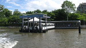
Station statistics
Address Wellington Road, East Brisbane
Coordinates 27°28′39″S 153°02′35″E / 27.4775°S 153.0431°E / -27.4775; 153.0431Coordinates: 27°28′39″S 153°02′35″E / 27.4775°S 153.0431°E / -27.4775; 153.0431
Other information
Accessible Handicapped/disabled access
Owned by Brisbane City Council
Fare zone 2 (TransLink)
Services
Preceding station   CityCat   Following station
Sydney Street
toward University of Queensland
CityCat Terminus

Mowbray Park is a ferry wharf in the suburb of East Brisbane used by the CityCat on the Brisbane River.

In January 2011 the wharf sustained a moderate damage during the devastating floods;[1][2] it was repaired and reopened on 14 February 2011.[3]

References

External links


Wikimedia Foundation. 2010.

Игры ⚽ Поможем решить контрольную работу

Look at other dictionaries:

  • Mowbray Park Ferry Wharf, Brisbane — Brisbaneferries Wharf wharf name=Mowbray Park image region=Brisbane East servicearea1=CityCat US1=Sydney Street DS1=New Farm Park suburb=East Brisbane street=Wellington Road zone=2 berths=1 busconnect=yes trainconnect=no pnr=yes phones toilets… …   Wikipedia

  • New Farm Park Ferry Wharf, Brisbane — Brisbaneferries Wharf wharf name=New Farm Park region=Brisbane Central servicearea1=CityCat servicearea2=Norman Park Cross River Ferry US1=Mowbray Park DS1=Hawthorne US2=Norman Park suburb=New Farm street=Brunswick Street zone=2 berths=1… …   Wikipedia

  • New Farm Park ferry wharf — New Farm Park Station statistics Address Brunswick Street, New Farm Coordinates …   Wikipedia

  • North Quay ferry wharf — North Quay Station statistics Address Queens Wharf Road, Brisbane CBD Coordinates …   Wikipedia

  • Northshore Hamilton ferry wharf — Northshore Hamilton Station statistics Address Northshore Riverside Park, Hamilton Parking No Other information Opened …   Wikipedia

  • Sydney Street Ferry Wharf, Brisbane — Brisbaneferries Wharf wharf name=Sydney Street image region=Brisbane Central servicearea1=CityCat US1=Riverside DS1=Mowbray Park servicearea2=Inner City Ferry US2=Dockside suburb=New Farm street=Sydney Street zone=2 berths=1 busconnect=yes… …   Wikipedia

  • List of Brisbane ferry wharves — This is a list of the suburban ferry wharves operating along the Brisbane River whose services are operated by the Brisbane City Council and its contractor Metrolink Queensland under the TransLink integrated public transport system.For detailed… …   Wikipedia

  • TransLink (South East Queensland) — This article is about the South East Queensland public transport system. For other uses, see Translink (disambiguation). TransLink Transit Authority Motto Integrated public transport for South East Queensland Formation …   Wikipedia

  • Lane Cove, New South Wales — For the local government area, see Municipality of Lane Cove. Infobox Australian Place | type = suburb name = Lane Cove city = Sydney state = New South Wales |left|thumbnail caption = Lane Cove pedestrian plaza, facing east lga = Municipality of… …   Wikipedia

Share the article and excerpts

Direct link
Do a right-click on the link above
and select “Copy Link”