- Corder House and Sydenham House
-
Corder House and Sydenham House 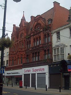
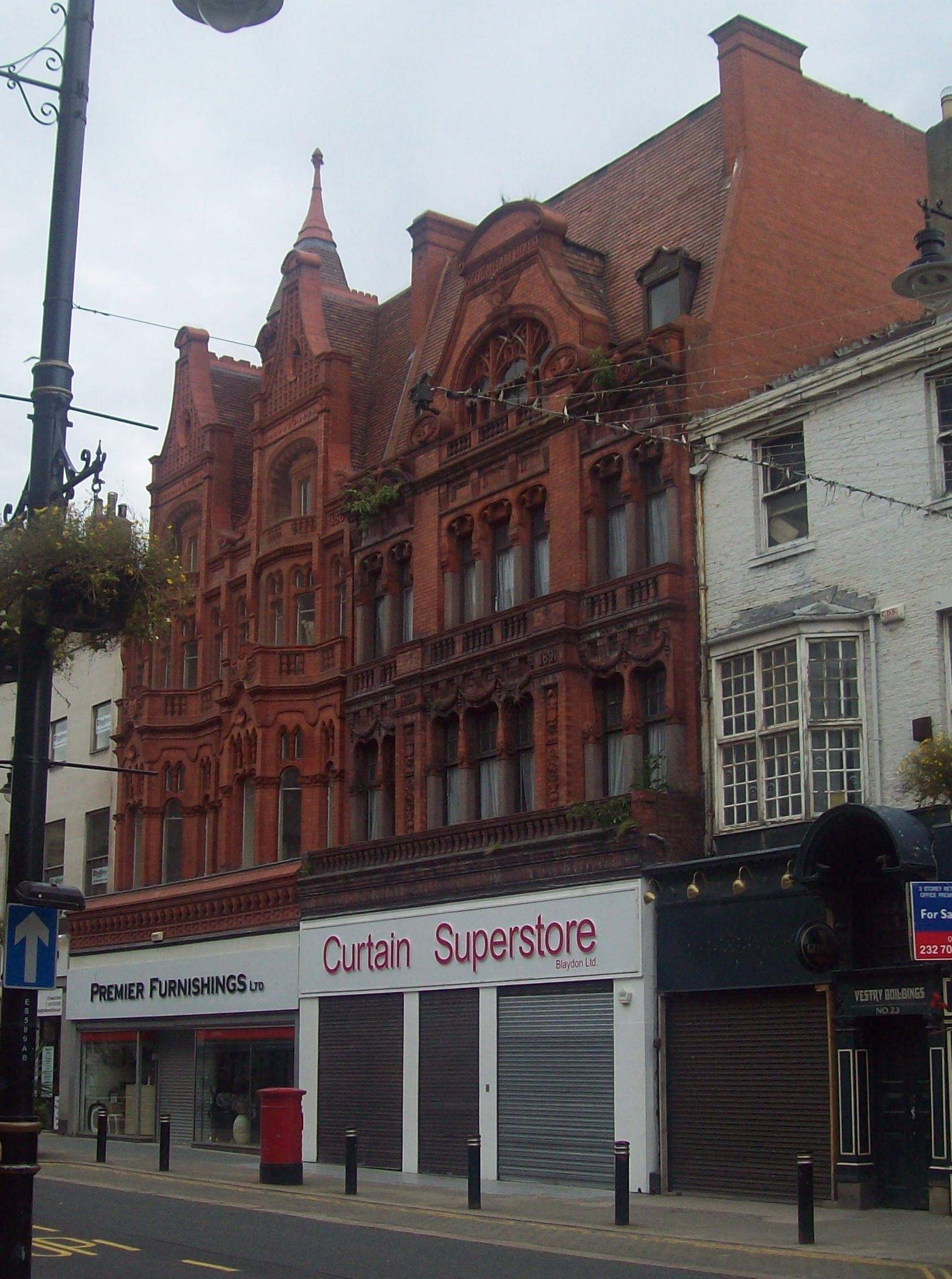
Corder House (left) and Sydenham House (right)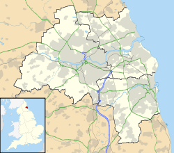
 Location within Tyne and Wear
General information Architectural style Neo-Moorish Address 21 and 22 Fawcett Street Town or city Sunderland Country United Kingdom Coordinates 54°54′23″N 1°22′53″W / 54.906286°N 1.381487°W Construction started 1889 Completed 1891 Technical details Floor count 4 (each) Design and construction Architect Frank Caws Corder House and Sydenham House are two, adjacent, Grade II listed buildings on Fawcett Street, in Sunderland, Tyne and Wear, England. Designed by Frank Caws in the Neo-Moorish style, they were constructed in brick from 1889–1891 by David and John Rankin with terracotta features by J. C. Edwards of Ruabon.
Contents
Corder House
Corder House was constructed for a local drapery company, Corder's, owned by Alexander Corder. It is four storeys high, including the attic. The building has a ground floor panelled fascia and a cusped arcaded frieze with roll-moulded coping. The projecting canted bays on the arcaded first floor are flanked by narrow lights with Gothic capitals to the pilasters and the elaborate heads over the central lights of the canted bays; all are with paired, mullioned cusped overlights and a dripstring. The second-floor central balustraded balcony has panels with Gothic letters; the curvilinear windows with paired arcaded top lights have shallow canted centres under the balustraded attic balconies. The elliptical-headed cusped attic arches to the recessed windows are flanked by scrolls and pilasters which rise to high shaped gables with terracotta patterns, central oval lights, and raised segmental pediments. The dates 1856 and 1890 are in the outer panels at the eaves level. The steeply pitched roof has a central lantern with Gothic lights and a high, conical roof.
Sydenham House
Sydenham House is four storeys high, including the attic. It has a moulded ground floor fascia and frieze below a full-width balcony with a stone balustrade. The first floor windows, tripartite in the centre and paired in the outer bays, have upper glazing bars in curvilinear heads below the swags and the second floor balcony which projects in the centre over panelled pilasters defining the first floor central bay. The square-headed second floor lights have raised arches with pendants, the central bay is defined by plain pilasters with scrolled pediment heads under a panelled band and outer scrolled pediments. The central attic gable has a raised segmental pediment over an eclectic tracery of a wide arched light containing smaller cusped lights. Its steeply pitched roof has an end chimney.
See also
Sources
- "Listed Buildings - Number:920-1/20/69 - Description". http://www.sunderland.gov.uk/apps/ListedBuildings/lbbuildingdetails.asp?Id=920-1/20/69. Retrieved 2008-08-10.[dead link]
- "A walk through the Central Sunderland Conservation Area (Sunniside)". http://www.sunderland.gov.uk/Public/Editable/Themes/Environment/PlanningandEnvironment/implementation/conservation/centralsunderlandwalk.pdf. Retrieved 2008-08-10.[dead link]
- "Sunderland". http://www.lynnpearson.co.uk/Durham.pdf. Retrieved 2008-08-10.
Holy Trinity Church · Hylton Castle & Chapel · Phoenix Lodge · St Andrew's Church · St Peter's ChurchWashington Houghton-le-Spring Penshaw Monument · St Michael and All Angels ChurchDoxford House · Fulwell Acoustic Mirror · Fulwell Mill · Sunderland Minster · Monkwearmouth Station Museum · Old South Pier · Ryhope Pumping Station & Chimney · St George's Church · Empire Theatre · 11 Church Street EastHoughton-le-Spring City Centre Sunderland Museum · St Mary's Church · Mowbray Almshouses · Sunderland County Court · Corder House and Sydenham House · Elephant Tea Rooms · Green's Public House · The Isis · Sunderland Gas Board · Galen Building · Fitzgerald's Public House · Wearmouth Bridge · River Wear Commission Building · St Mary's Building · Wearmouth Rail Bridge · Sunderland Magistrates' Court · Sunderland and South Shields Water Company Building · Victoria Hall Disaster Memorial · Sunderland War Memorial · Burdon Road Masonic Temple · 4–25 Foyle Street · 28–40 and 43–48 West Sunnside · Medieval Arch & Wall · Central Buildings · Former General Post Office · Former Custom House · Maritime Buildings · 19, 20, 29 and 30 Villiers Street · West Park Church · 17–29, 32–42 & 45–58 Frederick Street · Mowbray Park (certain buildings) · Midland Bank · National Westminster Bank · Barclays Bank · Lloyds Bank · 11–17, 20–23 25–28 and 45–58 John Street · 2 & 3 Mary Street · 3–5 Albion Place · 19 & 31–33 Norfolk Street · 3 & 22 Athenaeum Street · Hutchinson's Buildings · The Londonderry · The Dun Cow · 1–7, 105–112, 114–118, 145, 170–173, 176, 211, 212 and 214–217 High Street West · 49–51 High Street East ·Monkwearmouth
and SouthwickMonkwearmouth Library · Monkwearmouth College · Wheatsheaf Hotel · North East Railway Stables · Holy Trinity Church · St Columba's Church · Hebron Church · 6 Back North Bridge Street · 57 and 58 Barclay Street · Southwick Limekilns · The Tramcar Inn · Thompson Memorial · Southwick War Memorial · 65–95 James Armitage Street · All Saints' ChurchRyhope
and BurdonRailway Inn · Ryhope Grange Farmhouse · St Paul's Church · The Chestnuts and The Wilderness · Burdon Hall · The Railway Inn · 14 Cliff Road · Ryhope War Memorial · Coqueda Hall · Ryhope Rent Office · Ryhope Pumping Station ·Ashbrooke
and ThornholmeBede Tower · Sunderland Synagogue · Christ Church · West Hendon House · St John's Church · Carlton House · Langham Tower · Ashburne House · The Crofts · Gray House · St George's House · 3–7 Douro Terrace · Valebrooke Gardens · Westburn House · 1–29 Thornhill Terrace · 1–15 Grange Crescent · 1–9 The Esplanade · Burdon House · 1–16 St Bede's Terrace · 1–24 Park Place East and West · Park Road Methodist Church ·Hendon
and GrangetownHendon Gas Works · Quayside Exchange · St Aidan's Church · Trafalgar Square Merchant Seaman's Almshouses · St Ignatius Church · Tavistock House · Sunderland East Community Centre · 10 Church Street East · Salisbury Street Steps · Sunderland Cemetery (certain buildings) · Former Methodist Manse · Bethesda Free Church · 17–23 Murton Street · 3–19 Ridley Terrace · North Dock (walls and mooring posts) · Hudson Dock (certain buildings) · Sunderland Harbour South Pier · Whylam Wharf · Bonded Warehouse ·Barnes
and HumbledonBarnes School · St Gabriel's Church · Kayll Road Library · Children's Hospital · Humbledon Pumping Station · Hill House · Bishopwearmouth Cemetery (certain buildings) · Barnes Park Bandstand ·Deptford, Millfield
and PallionThe Mountain Daisy Public House · St Joseph's Church · Queen Alexandra Bridge · St Mark's Church · St Luke's Church · Laing Fountain · Webster's RoperySilksworth
and TunstallSilksworth Hall · Tunstall Lodge · Silksworth Cottage · Tunstall School · Tunstall Hope Lodge ·North Hylton
and South HyltonFulwell, Roker
and Whitburn BentsFulwell Pumping Station · The Bents · Mere Knolls Cemetery (certain buildings) · Roker Park Bandstand · Roker Park Drinking Fountain · Roker Pier & Lighthouse · Andover · Fulwell Limekilns · 160, 162 & 164 Newcastle RoadMiddle and
East HerringtonWashington Blue House Villa · 'F' Pit · The Old Hall Smithy · Low Barmston Farmhouse · Red Hill House · Usworth Hall · Fatfield House · Our Blessed Lady Immaculate Church, Washington ·
Certain buildings in/on: Peareth Hall Road · The AvenueHoughton-le-Spring Houghton-le-Spring Davenport and Lilburne Almshouses · Lilburn House · Gilpin House · The Villa · The Rectory · St Michael's Church · The Old Mill · Laburnum House · Houghton Mines Rescue Station · High Farm House · St Cuthbert's Church · Stoneygate Pumping Station · Philadelphia Power Station
Certain buildings in/on: Nesham Place · Front Street, Newbottle · Philadelphia LaneHetton-le-Hole St Nicholas' Church, Hetton-le-Hole · St Nicholas House · Easington Lane War Memorial · Pithead Baths · Smithy · Primitive Methodist Church ·Newbottle Russell House · Newbottle Working Men's Club · St Matthew's Church, Newbottle · Cellar Hill House ·Penshaw All Saints' Church · Penshaw House · Alice Well · Accommodation Arch · Boundary StoneCategories:- Grade II listed buildings in Tyne and Wear
- Buildings and structures in the City of Sunderland

Wikimedia Foundation. 2010.