- Unused highway
-
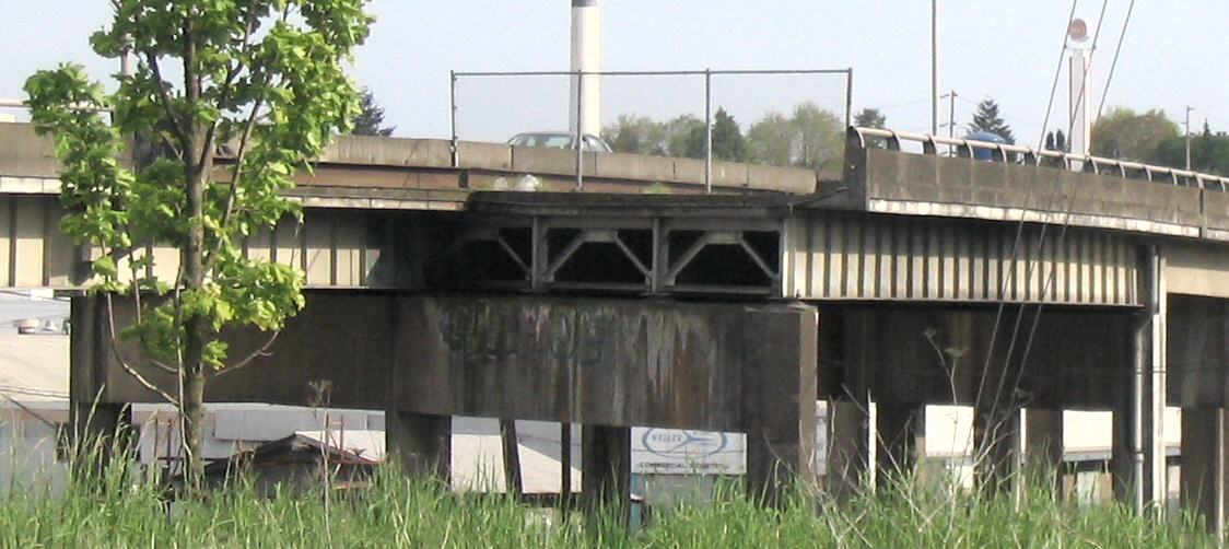
 An unused ramp in Portland, Oregon at the western terminus of I-84 on the east bank of the Willamette River[1]
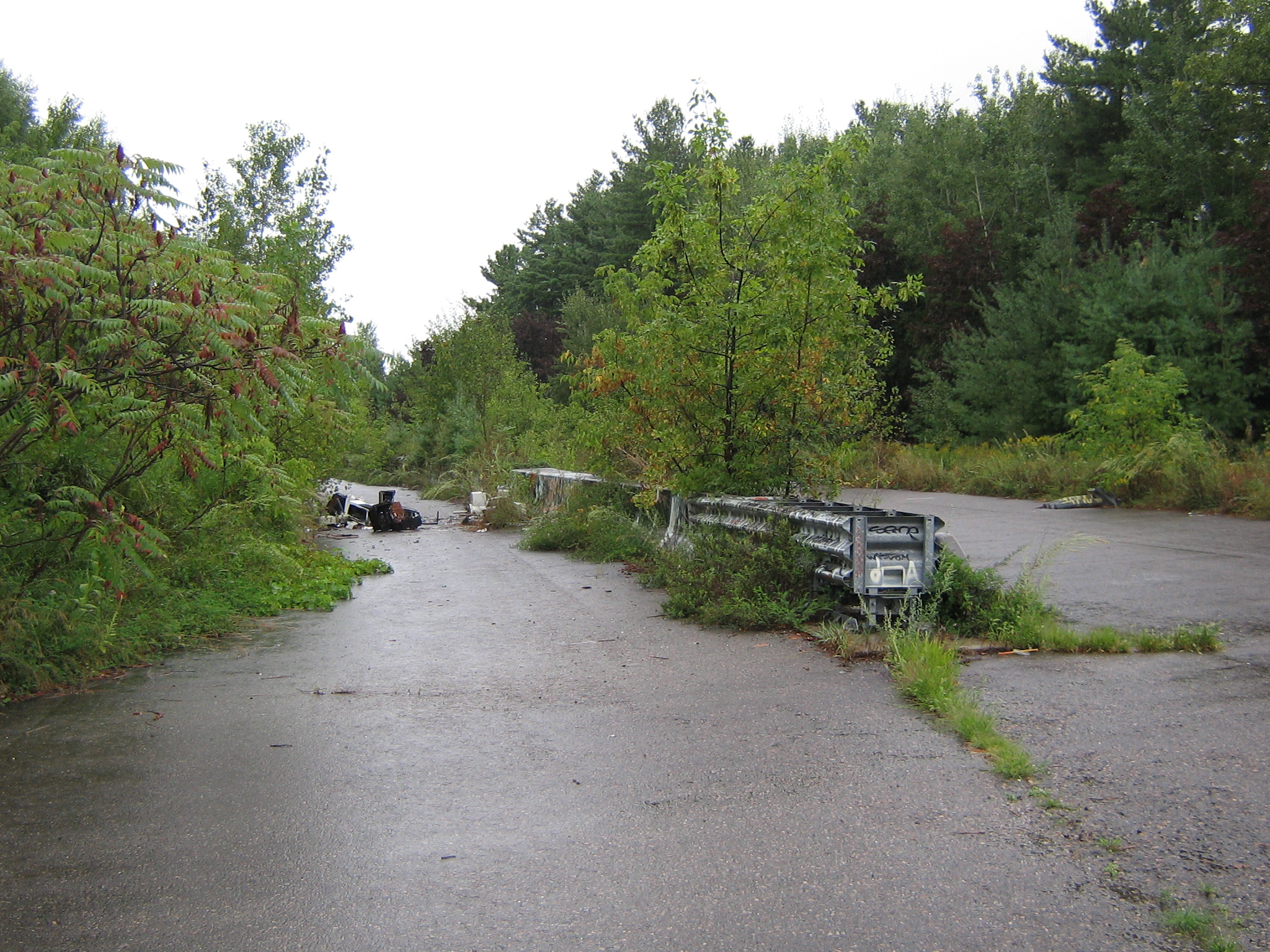
 An unused section of divided highway approaching Interstate 189 in Burlington, Vermont, (looking southward from: 44°26′56.69″N 73°13′3.4832″W / 44.4490806°N 73.217634222°W); some lanes are now blocked by discarded electronics.
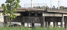 An unused ramp in Portland, Oregon, the Grand Avenue leg of the Union Avenue (MLK Way) Viaduct, built in the 1960s[2]
An unused highway is a highway or highway ramp that was partially or fully constructed, but was unused or later closed. An unused ramp can be referred to as a stub ramp, stub street, stub-out, or simply stub.[3]
Contents
Examples
Some examples of reasons for unused highways include:
- An older portion of roadway being left unused by a highway realignment. The abandoned Pennsylvania Turnpike is one instance of this, where two two-lane tunnels and four-lane approaches were bypassed with four-lane cuts. The old tunnels and approach roadways in this case are being rehabilitated for a multi-use trail.
- A highway being closed and demolished, where stubs remain on intersecting roads. Examples include ramps from the Embarcadero Freeway that remained on the Bay Bridge approach (Interstate 80) in San Francisco after the demolition of the Embarcadero Freeway proper. The remaining ramps were demolished in 2010-11 during demolition of the old Transbay Terminal to make way for the new Transbay Transit Center.
- Highway construction begins but is canceled, possibly because of a freeway revolt. Examples include the Pennsylvania Route 23 "Goat Path" east of Lancaster, which was graded for a four-lane expressway. The project was canceled before paving could commence, so the roadbeds were planted over with grass.[4] In London, the M11 motorway has two short unused slips at Junction 4 (Charlie Brown's) which would have been a link for the M12 motorway to head east into Essex.[5][6][7]
- Stubs are built to connect to a highway that is not yet constructed. These stubs ramps are very common in the state of North Carolina, where they will eventually connect to new stretches of I-73, I-74, I-485 and I-840, among others, along the Greensboro Urban Loop.
- The highway is used for a different purpose than originally intended. The east end of Interstate 70 in Baltimore[8] and the stub of Interstate 95 inside the Capital Beltway northeast of Washington are two examples due to cancellations of their alignments within the inner city. Both of these stubs are used for park-and-ride facilities. In England, improvement works in 1987 rerouted the A47 in Rutland near Wardley resulting in an unused stretch of carriageway being left behind which functions only as access to a transmitting station.[9] Part of the A2 in Kent was realigned in 2009, leaving a substantial part of the original road intact. Part of the road has been made into a public park. On Interstate 90 near Albany, New York, an interchange was built for the never-to-be Interstate 687; that interchange (labeled as Exit 5A off I-90) now serves as an exit for Corporate Woods Boulevard. The exit ramps occupy nearly as much space as the area they serve.[10]
- The highway has unused lanes. The 1000 Islands Parkway contains two "ghost lanes" for its entire 40 km length. Its right-of-way is four-lane-divided, as it was originally intended to serve Highway 401, a portion of Canada's busiest highway. When the 401 was ultimately constructed further inland, two lanes of the original right-of-way were used for the parkway, the rest becoming small pedestrian or bicycle trails laid out in an otherwise-vacant freeway-grade right-of-way.
Railway and other stubs
Stubs may also be found in rail networks. Near Lambert Airport in St. Louis, Missouri, a stub exists for the city's light rail system, Metrolink, for a future northern extension. In California, an abandoned stretch of railway connecting the Colma (BART station) with the South San Francisco Caltrain Station is overgrown with weeds and sections are paved over with asphalt. It runs along Railway Avenue for most of the stretch, then enters suburban neighborhoods via South San Francisco. From Colma, it crosses over the El Camino Real before entering a tunnel.
At the Kennedy Space Center, there is a stub off the crawlerway for launch pad 39B. It was originally to be extended to a never-built launch pad 39C.28°36′20″N 80°37′16″W / 28.605651°N 80.621012°W
See also
References
- ^ "Location". Maps.google.com. http://maps.google.com/maps?ie=UTF8&ll=45.526299,-122.666216&spn=0.005337,0.009109&t=h&z=17. Retrieved 2010-03-23.
- ^ "Location". Maps.google.ca. http://maps.google.ca/maps?f=q&hl=en&geocode=&q=Portland,+OR&ie=UTF8&ll=45.506546,-122.661211&spn=0.002008,0.004989&t=h&z=18&om=1. Retrieved 2010-03-23.
- ^ "CITY OF UNION, KENTUCKY." City of Union, Kentucky 23 June 2006. 15 Jan. 2007 [1].
- ^ Pennsylvania Department of Transportation, PA 23 EIS: Project History. Retrieved December 28, 2006.
- ^ "essex - Google Maps". Local.google.co.uk. http://local.google.co.uk/maps?f=q&hl=en&q=essex&layer=&sll=51.585177,0.148315&sspn=0.178765,0.692139&ie=UTF8&om=1&z=18&ll=51.597044,0.044101&spn=0.001396,0.005407&t=k&iwloc=addr. Retrieved 2010-03-23.
- ^ "essex - Google Maps". Local.google.co.uk. http://local.google.co.uk/maps?f=q&hl=en&q=essex&layer=&sll=51.585177,0.148315&sspn=0.178765,0.692139&ie=UTF8&om=1&z=19&ll=51.601051,0.048052&spn=0.000698,0.002704&t=k&iwloc=addr. Retrieved 2010-03-23.
- ^ "essex - Google Maps". Local.google.co.uk. http://local.google.co.uk/maps?f=q&hl=en&q=essex&layer=&sll=51.585177,0.148315&sspn=0.178765,0.692139&ie=UTF8&z=19&ll=51.602298,0.048607&spn=0.000698,0.002704&t=k&om=1&iwloc=addr. Retrieved 2010-03-23.
- ^ "i-70, baltimore, md - Google Maps". Maps.google.com. http://maps.google.com/maps?f=q&hl=en&geocode=&q=i-70,+baltimore,+md&sll=39.217293,-76.756496&sspn=0.058052,0.104713&ie=UTF8&ll=39.30137,-76.711832&spn=0.007049,0.013089&t=h&z=17&iwloc=addr. Retrieved 2010-03-23.
- ^ Unused Stretch of A47, Rutland on Wikimapia
- ^ "corporate woods blvd. albany, ny - Google Maps". Maps.google.com. http://maps.google.com/maps?f=q&hl=en&geocode=&q=corporate+woods+blvd.+albany,+ny&sll=37.0625,-95.677068&sspn=59.769082,107.226563&ie=UTF8&ll=42.68335,-73.768945&spn=0.013771,0.026178&t=h&z=16. Retrieved 2010-03-23.
Categories:- Cancelled highway projects
- Road junction types
- Streets and roads

Wikimedia Foundation. 2010.