- 1998 Nashville tornado outbreak
-
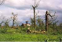
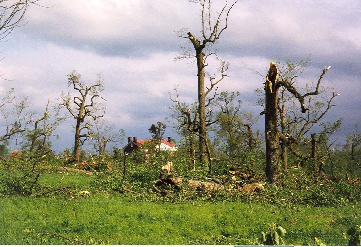
1998 Nashville tornado outbreak Tornado damage to trees near The Hermitage
Date of tornado outbreak: April 15–16, 1998 Duration1: 2 days [1][2] Maximum rated tornado2: F5 tornado Tornadoes caused: 61 Damages: >$133 million (1998 USD)[3] Fatalities: 12 [2] Areas affected: Tennessee, Arkansas, Alabama, Illinois, Kentucky 1Time from first tornado to last tornado
2Most severe tornado damage; see Fujita ScaleThe 1998 Nashville tornado outbreak was a two-day tornado outbreak which affected portions of the Midwestern United States, Mississippi and Tennessee Valleys on April 15 and April 16, 1998, with the worst of the outbreak taking place on the second day. On that day, at least ten tornadoes swept through Middle Tennessee—three of them touching down in Nashville, causing significant damage to the downtown and East Nashville areas. Nashville became the first major city in nearly 20 years to have an F2 or larger tornado make a direct hit in the downtown area.[4]
In addition, the outbreak produced several other destructive tornadoes in Middle Tennessee. One of them, southwest of Nashville, was an F5 tornado—one of only two ever recorded in the state. That tornado remained mainly in rural areas of Wayne, Lawrence and Maury counties. Other tornadoes during the 2-day outbreak struck Arkansas, Alabama, Illinois and Kentucky.
12 people were killed by tornadoes during the outbreak including 2 in Arkansas, 3 in Kentucky and 7 in Tennessee including one in Nashville and three by the F5.
This tornado outbreak occurred at the end of the record-setting 1997-1998 El Niño event.
Contents
Meteorological synopsis

Outbreak death toll State Total County County
totalArkansas 2 Mississippi 2 Kentucky 3 Barren 2 Metcalfe 1 Tennessee 7 Bradley 1 Davidson 1 Dyer 2 Wayne 3 Totals 12 All deaths were tornado-related One week after the Birmingham Tornado Outbreak took place across Alabama and Georgia on April 8–9, 1998 and several other states on April 7, a similar pattern developed across the Midwest and southeastern United States starting on April 15, 1998. A very strong low pressure system developed across the central part of North America and was associated with a long cold front. Ahead of the storm, the warm moist air generated from the Gulf of Mexico increased the likelihood for a significant weather event. On April 15, activity developed across the Mid-Mississippi Valley and southern Ohio Valley where several tornadoes touched down in Illinois starting in the late afternoon before moving in Arkansas during the overnight hours where the first fatalities were reported.
On April 16, as the main low pressure system was near the Great Lakes and its cold front crossing the Mississippi River, dew points reached the mid to upper 60s across the Tennessee Valley while later in the day, CAPE values reached 1600 J/kg while dry air intrusion was also on the rise increasing the threat of severe weather across the area. As the bulk of the supercells moved out of Arkansas, the tornadic activity was slower during the morning hours before re-intensifying west of Nashville early in the afternoon.[4] Major tornadoes struck from southern Tennessee to southern Kentucky with additional storms as far north as Michigan and several other storms in Alabama across Walker and Cullman Counties, which was slightly north of the areas that were hardest hit by the previous outbreak.
Confirmed tornadoes
Confirmed
TotalConfirmed
F0Confirmed
F1Confirmed
F2Confirmed
F3Confirmed
F4Confirmed
F561 25 15 12 7 1 1 Nashville tornadoes
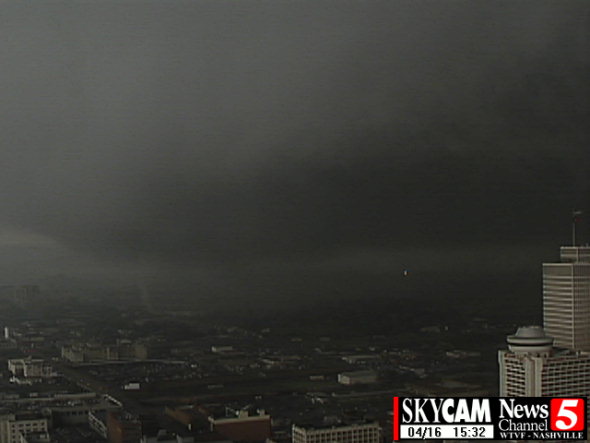
The storm first crossed into Nashville at around 3:30 p.m. (CDT), moving from west to east across the city. Of the three tornadoes that hit Nashville, one was rated F3 on the Fujita scale, and the other two were rated F2.[5]
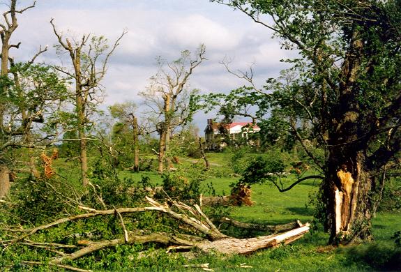
 Tornado Damage near the Tulip Grove Mansion, part of The Hermitage
 Tornado Damage near the Tulip Grove Mansion, part of The Hermitage
 The Tennessee state flag which flew over the Capitol during the outbreak. Note that the middle star emblem was ripped out during the storm. This flag is currently on display at the Tennessee State Capitol.
The F3 tornado touched down near the intersection of Charlotte Pike and Forty-sixth Avenue and traveled directly through downtown. After crossing the Cumberland River, it passed through East Nashville, Donelson, and Hermitage before finally lifting near Hartsville in Trousdale County.[6] At least 100 people were injured by the storm.[7] Vanderbilt University student Kevin Longinotti was trapped under a fallen tree in Centennial Park and later died from his injuries.[8] 300 homes were destroyed and 600 businesses were damaged or destroyed.[9] The Tennessee State Capitol and Union Station were both damaged. More than 6,000 trees were felled by the storm, including nearly 1,200 at The Hermitage, the home of President Andrew Jackson.[9] Several cranes at the construction site of the Tennessee Titans' new stadium (now known as LP Field) were damaged. Total property damage within Nashville was estimated at over $100 million.[10]
The second tornado touched down less than an hour later between downtown Nashville and the Nashville International Airport. It damaged several homes and toppled numerous trees in both Davidson and Wilson Counties. Outbuildings and cars were also damaged or destroyed and 20 hogs were killed in the storm. There were no human casualties and damage was estimated at $3 million in Wilson County alone. The tornado was rated an F2.[11][12] The third Nashville tornado struck 45 minutes after the second tornado and caused damage mainly to windows, trees, and power lines over a short path.[13]
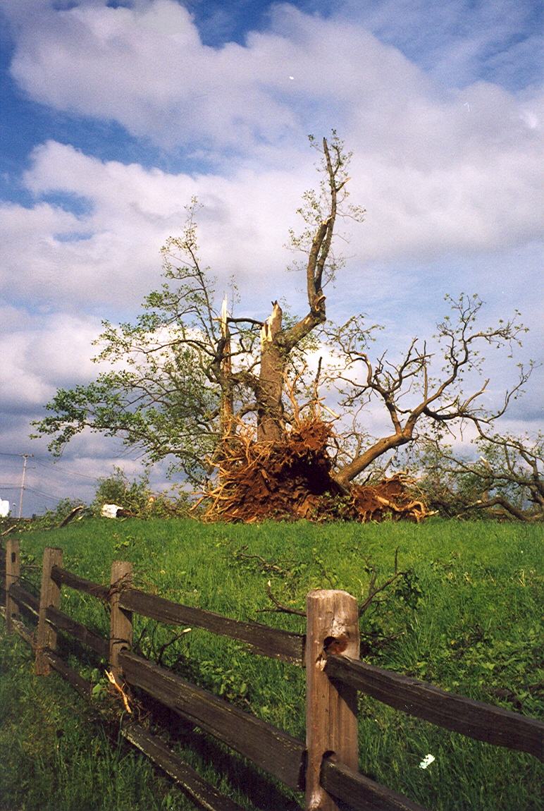
Southern Middle Tennessee F5 tornado
At the same time the tornadic storms developed and moved across the Nashville area, severe storms also developed across southwestern Tennessee east of Memphis. One particular supercell quickly intensified due to an outflow boundary left by earlier storms and there were also significant pressure drops across the same area. It begin producing severe hail near Lawrence County before a tornado touched down in Wayne County near Clifton at around 3:50 PM CST. In that county, 3 people were killed by the tornado including those inside a modular home and another inside a wooden frame home.
 Tornado Damage near the Tulip Grove Mansion, part of The Hermitage
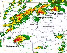 Radar image of the Nashville and southwestern Tennessee supercells (Courtesy of NOAA)
No other fatalities were reported as it traveled through sparsely populated areas and did not significantly affect any towns. However, many homes were completely leveled with some swept clean from their foundations. In Wayne County, 34 homes were destroyed and 36 others suffered minor to major damage while other structures were completely demolished including mobile homes.[14] An undetermined number of structures including brick homes were demolished in neighboring Lawrence County and livestock were killed.[15] In Giles County 5 homes and 8 mobile homes were destroyed while a gas tank ruptured.[16] In Maury County, no homes were demolished as it weakened to an F3 but several structures, including homes and businesses, sustained significant damage in the Culleoka area.[17] On many occasions, the tornado was at least one mile wide across Wayne and Lawrence Counties. A total of 36 people were injured and $30 million in damage was done along the 70-mile long path of the tornado which lifted northeast of Culleoka at around 5:30 PM CST.[4]
It is the most recent Tennessee F5 and only official one as the March 11, 1923 Pinson tornado took place before the introduction of the Fujita scale and before records were officially kept.
South Central Kentucky
South Central Kentucky also received severe weather from this outbreak. The most notable of the storms that occurred in South Central Kentucky that day was a particularly strong supercell storm that dumped baseball-sized hail on central Warren County including the Bowling Green central business district and Western Kentucky University causing massive amounts of damage to cars as well as structures. The storm also caused flash flooding in the area of WKU's main campus. The damage from the hail was so great that it seemed to overshadow the F3 tornado event happening in the southern part of the county, which was more rural. The tornado then moved into Barren County actually crossing a bend in the northern portion of Barren River Lake near the small town of Lucas. The tornado then would pass just south of downtown Glasgow and cross the Cumberland Parkway just west of the Barren/Metcalfe county line. It would then dissipate right at that county line. An F2 was later spawned by this supercell in Metcalfe County, crossing the Cumberland Parkway in the western part of the county and passing just to the south of the county seat, Edmonton.
See also
- List of North American tornadoes and tornado outbreaks
- List of tornadoes striking downtown areas
- April 6–8, 2006 Tornado Outbreak - 9 fatalities in the Nashville area.
- March 1933 Nashville tornado outbreak
References
- ^ Tornado History Project - Tornado Map
- ^ a b Tornado History Project - Tornado Map
- ^ Timothy W. Troutman, Timothy P. Marshall, and Mark A. Rose (2000). "A Comparison of WSR-88D Radar Velocity Signatures to Tornado Damage for the April 16, 1998 Tornado Outbreak in Middle Tennessee", Symposium on the Mystery of Severe Storms, American Meteorological Society.
- ^ a b c John D. Gordon, Bobby Boyd, Mark A. Rose, and Jason B. Wright (2000). "The Forgotten F5: The Lawrence County Supercell", National Weather Service paper. Visited May 8, 2005.
- ^ Middle Tennessee Tornadoes. Visited April 11, 2006.
- ^ Mark A. Rose. "The Nashville Tornado of March 14, 1933". Visited August 12, 2004.
- ^ "Tornadoes rip through heart of Nashville" from CNN.com. Visited August 12, 2004.
- ^ Ian Demsky. "Tornado sirens go unheard in many areas". The Tennessean, June 9, 2004.
- ^ a b http://tennessean.com/apps/pbcs.dll/article?AID=/20080416/NEWS01/804160420
- ^ NCDC Event Record for Nashville F3 tornado. Visited April 11, 2006.
- ^ NCDC: Event Details
- ^ NCDC: Event Details
- ^ NCDC: Event Details
- ^ NCDC: Event Details
- ^ NCDC: Event Details
- ^ NCDC: Event Details
- ^ NCDC: Event Details
External links
- Satellite imagery (University of Wisconsin–Madison).
- Photos of the aftermath in East Nashville (archived)
- Lawrence County F5 tornado Webpage
Categories:- F5 tornadoes
- Tornadoes of 1998
- Tornadoes in Tennessee
- History of Nashville, Tennessee
- 1998 in the United States


Wikimedia Foundation. 2010.