- New York State Route 163
-
NYS Route 163
Route information Maintained by NYSDOT Length: 11.97 mi[2] (19.26 km) Existed: 1930[1] – present Major junctions West end: 
 NY 5S / NY 80 in Fort Plain
East end:  NY 10 in Canajoharie
Location Counties: Montgomery Highway system Numbered highways in New York
Interstate • U.S. • N.Y. (former) • Reference • County←  NY 162
NY 164  →
→New York State Route 163 (NY 163) is an east–west state highway in Montgomery County, New York, United States. It runs from the village of Fort Plain to the town of Canajoharie in southern Montgomery County. With the exception of its eastern terminus, NY 163 is not signed with directions. Reference markers indicate its terminus in Fort Plain to be its western, although the route heads nearly due southward until Sprout Brook. Approaching that hamlet, it is named "Cherry Valley Road", and when NY 163 turns left to head eastward, CR 82 continues that road name directly to Cherry Valley. In Fort Plain, NY 163 follows Kellogg and Douglas Streets. NY 163 is a two-lane highway its entire length.
Contents
Route description
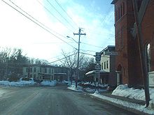 Southern split of the NY 80 / NY 163 overlap in Fort Plain
NY 163 begins concurrent to NY 80 at an intersection with NY 5S in the village of Fort Plain. NY 80 and NY 163 head southwest for two blocks before splitting. NY 163 heads southwest from here, crossing over Otsquago Creek as it exits the village limits and passes through the rural town of Minden. After passing through the hamlet of Hessville, the route turns to the south to enter the town of Canajoharie. The southward alignment continues to Sprout Brook, a community located on Canajoharie Creek, at which point the route curves back to the northeast. It loosely follows the creek to an intersection with NY 10, where NY 163 terminates.
History
The entirety of NY 163 was assigned as part of the 1930 renumbering of state highways in New York.[1]
Major intersections
The entire route is in Montgomery County.
Location Mile[2] Destinations Notes Fort Plain 0.00 NY 5S / NY 80 northEastern terminus of NY 80 / NY 163 overlap 0.15 NY 80 southWestern terminus of NY 80 / NY 163 overlap Town of Canajoharie 11.97 NY 101.000 mi = 1.609 km; 1.000 km = 0.621 mi References
- ^ a b Standard Oil Company of New York (1930). Road Map of New York (Map). Cartography by General Drafting.
- ^ a b "2008 Traffic Volume Report for New York State" (PDF). New York State Department of Transportation. June 16, 2009. pp. 175–176. https://www.nysdot.gov/divisions/engineering/technical-services/hds-respository/NYSDOT%20TVR%202008%20by%20Route.pdf. Retrieved February 1, 2010.
External links
Categories:- State highways in New York
- Transportation in Montgomery County, New York


Wikimedia Foundation. 2010.