- Mormon Island, California
-
Coordinates: 38°42′13″N 121°07′03″W / 38.7035°N 121.1174°W
 Drawing of Mormon Island
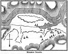
 Topographical map of Mormon Island in 1892
Mormon Island was once a mining community, which had an abundance of Mormon immigrants, seeking fortune along the American River. At its peak, the community once was home to 2500 residents, four hotels, a school, and seven saloons.[citation needed] The community dwindled after the California gold rush and only a scattered few families were left in the 1940s.
What was left of Mormon Island was eventually razed, as the Folsom Dam project was set to flood the town. The only visible remnant of this community is Mormon Island Cemetery,[1][2] a relocation cemetery located south of the lake on the dry side of Mormon Island Dam (off of Green Valley Road in Folsom, California). The cemetery is also home to other cemeteries that were flooded, as well as to relocated graves from Prairie City which were unearthed during construction of an on-ramp to Highway 50 from Prairie City Road.
Geographical information
The "island" was formed by the American River to the western, northern, and eastern sides and a man-made canal formed the southern side. The canal was used to divert water in an effort to find gold deeper within the river bed. Over time, the bulk of the town formed south of this site.[3]
When the lake is at very low levels, some foundations of buildings and an arched bridge can be seen.
References
- ^ Negro Hill Cemetery Relocation from the US Army Corps of Engineers, Sacramento District
- ^ "Plan would replace controversial grave markers". This Just In (blog) (CNN). May 6, 2011. http://news.blogs.cnn.com/2011/05/06/plan-would-replace-controversial-grave-markers/. Retrieved 2011-05-07.
- ^ Theodore, Henry (1898). History of California - Volume III. http://books.google.com/books?id=NUkOAAAAIAAJ&pg=PA55.
External links
- Negro Hill Cemetery Relocation from the US Army Corps of Engineers, Sacramento District
- Mormon Island History from myfolsom.com
Municipalities and communities of Sacramento County, California County seat: Sacramento Cities Citrus Heights | Elk Grove | Folsom | Galt | Isleton | Rancho Cordova | Sacramento
CDPs Antelope | Arden-Arcade | Carmichael | Clay | Courtland | Elverta | Fair Oaks | Florin | Foothill Farms | Franklin | Freeport | Fruitridge Pocket | Gold River | Herald | Hood | La Riviera | Lemon Hill | Mather | McClellan Park | North Highlands | Orangevale | Parkway | Rancho Murieta | Rio Linda | Rosemont | Vineyard | Walnut Grove | Wilton
Unincorporated
communitiesLocke | Paintersville | Parkway-South Sacramento | Ryde | Sloughhouse
Ghost towns Mormon Island | Sutterville
Categories:- Folsom, California
- Ghost towns in California
- California Gold Rush
- History of the Latter Day Saint movement
- Latter Day Saint movement in California
- Former settlements in Sacramento County, California


Wikimedia Foundation. 2010.