- Moquegua Region
-
This article is about the Moquegua Region. For its capital city, see Moquegua.
Moquegua Region — Region — Moquegua valley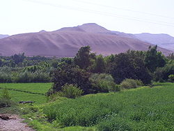
SealLocation of the Moquegua Region in Peru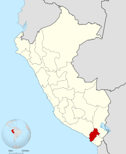
Country Peru Subdivisions 3 provinces and 20 districts Largest city Ilo Capital Moquegua Government – President María Cristala Constantinides Area – Total 15,733.97 km2 (6,074.9 sq mi) Highest elevation 3,756 m (12,323 ft) Lowest elevation 0 m (0 ft) Population (2004 estimate) – Total 163,757 – Density 10.4/km2 (27/sq mi) UBIGEO 18 Dialing code 053 ISO 3166 code PE-MOQ Principal resources Copper, olives and avocado. Poverty rate 29.6% Percentage of Peru's GDP 1.43% Website www.regionmoquegua.gob.pe Moquegua is a small department in southern Peru that extends from the coast to the highlands. The region's name is of Quechua origin and means "quiet place". The regional capital is the city of Moquegua, but the port city of Ilo is more commercially active.
Contents
Geography
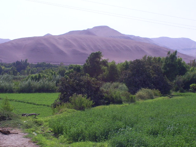
The region's volcanoes and its geomorphology make its geography remarkable. It is formed by upstream portion of the Tambo River, one of the most torrential coastal rivers, which forms deep valleys that can be divided into three sectors, the first one being in the northwest, forming the Puquina-La Capilla sector. These are veritable oasis enclaved in the rocks; arid hillsides and some terraces where horticulture is possible. High quality alfalfa as well as fruits, especially grapes, are produced here, due to a good climate and a rich soil. The second sector is the valley of Omate, one of the most populated and fertile soils of the department. The Ubinas Volcano, Peru's most active volcano, is located nearby. In the hillsides, the land is fertile in contrast with the desolation and sterility of its highlands. In the southern part of the Tambo River is located the town of Carumas, which along with Puquina and Omate, are the vital centers of this geography. The Moquegua River is a short run one and is formed by its tributaries: the Torata, Huaracane and Tumilaca rivers. After passing through the regional capital, it digs deep into a canyon called the Osmare.
Boundaries
The Moquegua Region is bordered by the regions of Arequipa on the north, Puno on the east, Tacna on the south, and the Pacific Ocean on the west.
Demographics
Population
According to the 1993 Census, the Moquegua Region has a population of 128,747 inhabitants, 51.9% of which (66,843) are male and 48.1% (61,904) are female.
As of 2002[update], the Instituto Nacional de Estadística e Informática esimates the region's population to be 156,750.
Languages
Spanish is spoken at home by 75% of the population; while others speak Aymara (12.7%), Quechua (10.9%), other indigenous languages (0.1%) and foreign languages (0.2%).
Immigration
Persons originating from other regions of the country make up 37.8% of the population and 0.2% of residents were born abroad.
The largest immigrant groups come from the Puno Region (14.7% of the total population) and the Arequipa Region (9.9%).
Age
The population is spread out with 43.3% under the age of 20, 9.9% from 20 to 24, 28.6% from 25 to 44, 13.4% from 45 to 64, and 4.8% who are 65 years of age or older.
Education
Secondary education has been attended by 33.3% of the population and 5.5% also have graduated from non-university higher education, while 4.3% have complete university studies. 37.9% only have attended primary education and 7.1% have not had any education.
The illiteracy rate in the region is 10%.
Political division
 Map of the Moquegua region showing its provinces
The region is divided into 3 provinces (Spanish: provincias, singular: provincia), which are composed of 20 districts (distritos, singular: distrito).
Provinces
The provinces, with their capitals in parenthesis, are:
- General Sánchez Cerro (Omate)
- Ilo (Ilo)
- Mariscal Nieto (Moquegua)
History
Inca oral tradition as documented by the Spanish chroniclers has long held that the present-day Moquegua Region was inhabited by small groups of natives known as pukinas and kollas long before the arrival of the Incas. According to chronicler Garcilaso de la Vega, it was Inca Mayta Cápac who organized the military expedition to expand the domains of the Cusco monarchs along this part of the coast. Since these were fertile lands, capable of supporting a larger population, the Inca army officers in charge decided to establish the towns of Cuchuna and Moquegua. In doing so, they were also protecting the Inca domain over the conquered lands.
Archaeological research conducted over the past several decades has shed considerable light on the ancient history of Moquegua, giving this remote section of Peru a unique place in the history of Peru. Archaeological surveys and excavations, documented in myriad professional publications, as well as books for the public available at Moquegua's Museo Contisuyo, demonstrate a sequence of occupation stretching from more than 10,000 B.C. through the present day.
There is no accurate data on the Spanish conquest or the founding of the city of Moquegua by its army. Presumably, it was founded on November 25, 1541 by Pedro Cansino and his wife, Josefa de Bilbao.
The named after him.
During the War of the Pacific, Moquegua suffered the invasion of Chilean troops. This army looted all buildings —including churches—, tortured women, and took people's jewelry.
Tourism
In the city
The attractions in the city of Moquegua are Main Square which features a fountain made and built in France by the Engineer Gustave Eifel, Santo Domingo Church contains the image of Santa Fortuna, a martyr, from the first centuries of Christianity who is worshipped by the faithful. Contisuyo Museum is also located in the city of Moquegua. The museum exhibits a variety of archaeological remains of the Uros and Puquina cultures as well as an explanation of the time period in which different cultures settle in this region.[1]
Other attractions in the city are casa del regidor perpetuo de la ciudad and casa de Alayza, which are houses built with architecture of the eighteen century.[2]
Outside the city
Attractions outside the city are Samegua which has the best typical food restaurants for tourists. Samegua also produces good quality avocados which are the reason why it's called the avocado territory. Another attraction located 24 km from Moquegua is Torata that is a district that offers the visitor a picturesque environment in which the visitor can admire the traditional ridged roof houses, the Torata Church, the stone windmills from the viceroyal period, and Sabaya and Camata an Inca administrative center known as the Machu Picchu of Moquegua. In addition at about 18 km northeast of Moquegua is found Mount Baul a geological formation which appear to have been cut perpendicular in the top area and it also bears a resemblance to the type of chest of trunk that was utilized all over Peru in the old days.[1]
Another attraction outside of the city is Ilo located 90 km from Moquegua. Ilo is one of the most tourist visited places in Moquegua. The main places to visit in this town are: Punta Coles, Los Olivares, and El Puerto,La Glorieta Jose Galvez,San Geronino church and beautiful beaches like Roca del Rio.[1][3] This town is not only a tourist place; it is also one of the industrial ports in southern Peru.[4]
Also at about 140 km northwest of Moquegua is Omate, town known as Villa de Omate that produces pisco and wine. The town is also considered to be one of the most important producing centers in Peru. The attractions in Omate are The Viceroyal Church, the Quinistacas Sanctuary, the Utucam Thermal baths, and the Tambo river. Other places of interest in the Outskirts of Moquegua are Puente Bello, Putina, Ichuna and Tolapalca thermal baths.[1]
Festivities
In Moquegua there are two main Festivities that attract tourist; one of them is Santo Domingo Fortunata Festival. This festival is held on October 14; it is an important religious festival in which the faithful from not only Moquegua but different places in Peru traveled to this town to join the Procession of the Image of the virgin and martyr St. Fortunata. Activities such as fairs, cultural and recreational events occur in this festival too.
The other main festival for the region of Moquegua is Moquegua Tourism Week. This festival starts in November and it holds competitions of typical dishes and beverages, a show with typical dances, and fairs.[1]
Gastronomy
The Region of Moquegua offers a variety of typical food to his visitors. Some of the typical dishes offered are patasca moqueguana or Caldo de Mondogo, which is a soup made with cow innards, corn, and mint and Picante de Cuy that is Guinea pig stew cooked in a peanut and hot pepper sauce. Other typical dishes are Chupe de Camarones that is a shrimp soup made with eggs, milk, and oregano. In addition, there is also the well known, Cebiche de Jurel or Mixto, Parihuela, Chupin de Pejesapo, Sudado de manchas, Aguadito de Mariscos, Chicharron de Pulpo, Picante de Mariscos, and Cuy Frito.
The most typical desserts in the Moquegua region are majarblanco which is a sweetened, condensed milk cooked down and used as a spread, alfar de penco which is a soft cookie, corn cake, guargueros, and oquendos. The most traditional drinks are macerado de damasco which is a peach liqueur made with Pisco, leche de monja, a liqueur that is made with a cordial, eggs, and lemon. Other traditional drinks are Chimbango de tres higos a liqueur combined of red, black, and green figs. In addition wine, pisco, licorice, cognac, and other pisco based fruit liqueurs are traditional drinks of this region. [5]
Transportation and Tourist Information
Modes of transportation to Moquegua Region are by air or overland transport. The Moquegua Region has two airports: Hernan Turque Podesta Airport in Moquegua city and Ilo Airport located in Ilo. Overland transportation in Moquegua city is by bus, and in Ilo there is a bus station called Pampa Inalambrica. Tourist information and assistance services are found in the web page iperu@promperu.gob.pe.[5]
See also
References
- ^ a b c d e "Tourist Information Moquegua". http://www.peru.info/temario/attach/1311.pdf. Retrieved 05 October, 2010.
- ^ "Peruvian Cities". http://www.traficoperu.com/english/ciud19.htm. Retrieved 16 October 2010.
- ^ "La glorieta Jose Galvez". http://www.perutoptours.com/index17ilo_glorieta_jose_galvez.html. Retrieved 18 October 2010.
- ^ "Moquegua". http://www.everythingperu.com/moquegua.html. Retrieved 16 October 2010.
- ^ a b "Useful Information of Moquegua". http://www.peru.info/s_ftociudades.asp?pdr=1216&jrq=3.17.1.3&ic=2&ids=3975. Retrieved 05 October, 2010.
External links
- [1] - Things to do in Moquegua site - Part of the Museo Contisuyo website
- (Spanish) Gobierno Regional de Moquegua - Moquegua Regional Government Website
 Regions of Peru
Amazonas · Ancash · Apurímac · Arequipa · Ayacucho · Cajamarca · Callao · Cusco · Huancavelica · Huánuco · Ica · Junín · La Libertad · Lambayeque · Lima · Loreto · Madre de Dios · Moquegua · Pasco · Piura · Puno · San Martín · Tacna · Tumbes · Ucayali
Peru's Lima Province is not part of any region.Categories:

Wikimedia Foundation. 2010.