- 2001 southern Peru earthquake
Earthquake
title=2001 southern Peru earthquake
date=June 23 ,2001 
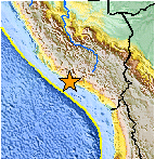
Map of the Peru coastline, showing location and strength of quake. Star marksepicenter .
magnitude = 8.4 Mw
depth=convert|33|km|mi|0
location=coord|16.26|S|73.64|W
countries affected = PER
casualties = 75 confirmed dead, 2,687 injuredciteweb|url=http://neic.usgs.gov/neis/eq_depot/2001/eq_010623/|publisher=United States Geological Survey |title=Magnitude 8.4 NEAR COAST OF PERU|accessdate=2008-06-14] The 2001 southern Peru earthquake was a magnitude 8.4earthquake that occurred at 20:33:14UTC (15:33:14 local time) on Saturday,June 23 ,2001 . The quake affected thePeru vian regions of Arequipa, Moquegua and Tacna. It was the most devastating earthquake in Peru since the catastrophic1970 Ancash earthquake and globally the largest earthquake since the1965 Rat Island earthquake .Tectonics and background
The earthquake occurred at the boundary between the
Nazca andSouth American plates . The two plates are converging towards each other at a rate of about 78mm per year. The earthquake occurred as thrust-faulting on the interface between the two plates, with the South American plate moving up and seaward over the Nazca plate. Southwestern Peru has a history of very large earthquakes. The June 23 shock originated just southeast of the source of a magnitude 7.7 earthquake that occurred in 1996, and it appears to have involved rupture of part of the plate boundary segment that produced an earthquake of magnitude approximately 9.0 in 1868. The 1868 earthquake was destructive in towns that were heavily damaged in the June 23 earthquake. The 1868 earthquake produced a tsunami that killed thousands of people along the South American coast and also caused damage in Hawaii and alarm in Japan.Complex event. The initial onset consists of two events separated by about 6 seconds. It is followed by at least one larger complex event occurring about 40 seconds later.Damage and casualties
At least 75 people were killed, including 26 killed by a tsunami. 2,687 were injured, 17,510 homes were destroyed and 35,549 homes damaged in the Arequipa-Camana-Tacna area. An additional were 64 people missing due to the tsunami in the Camana-Chala area. Landslides blocked highways in the epicentral area. Many of the historic buildings at Arequipa were damaged or destroyed. Some people injured and damage reported in the Arica, Chile area. Felt at Arica, at Iquique, at Calama and at
Tocopilla ,Chile . Felt strongly in much of southern Peru and northern Chile. Also felt inBolivia . Tsunami runup heights near Camana are estimated from field evidence to have reached approximately 7m at some locations; at other locations, the tsunami inundation distance extended more than 1 km inland from the coast. Tsunami wave heights (peak-to-trough) recorded from selected tide stations: 2.5m at Arica; 1.5m at Iquique; 1.0m at Coquimbo, Chile.ee also
*
Earthquakes in Peru References
External links
* [http://www.igp.gob.pe/cns/reportes/2002/sis_230602_areq/Documentos%20pdf/sismo6.pdf Análisis del Terremoto del Sur del Perú, 23 de Junio 2001, Mw= 8.4 Utilizando Datos Locales]
Wikimedia Foundation. 2010.
