- Richland, New Jersey
-
Richland is an unincorporated area within Buena Vista Township in Atlantic County, New Jersey, United States. The area is served as United States Postal Service ZIP Code 08350.
As of the United States Census, 2000, the population for ZIP Code Tabulation Area (ZCTA) 08350 was 743.
On April 26, 2004, the Buena Vista Township Committee voted to temporarily rename the community of Richland, a section of Buena Vista Township. For the first half of the month of May 2004, Richland became Mojito, New Jersey, named after the Cuban rum drink. Bacardi had offered to give the township $5,000 for recreation projects in exchange for commemorating the new name with a sign on U.S. Route 40 for those weeks.[1] Richland was chosen because it is home to the family-run Dalponte Farms, a major East Coast supplier of mint, an essential ingredient of the mojito.
Education
St. Augustine College Preparatory School is a Catholic high school located in Richland that is operated under the jurisdiction of the Diocese of Camden.[2]
References
- ^ National Mojito Month, Cocktail Times. Accessed October 8, 2007.
- ^ Atlantic County Schools, Roman Catholic Diocese of Camden. Accessed July 22, 2008.
External links
- Census 2000 Fact Sheet for Zip Code Tabulation Area 08350 from the United States Census Bureau
- Mojito cocktails
Municipalities and communities of Atlantic County, New Jersey Cities 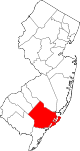
Boroughs Town Townships Buena Vista | Egg Harbor | Galloway | Hamilton | Mullica | Weymouth
CDPs Communities Dorothy | Elwood | Landisville | McKee City | Mizpah | Richland | Smithville | Sweetwater
Coordinates: 39°29′30″N 74°52′15″W / 39.49167°N 74.87083°W
Categories:- Unincorporated communities in New Jersey
- Populated places in Atlantic County, New Jersey


Wikimedia Foundation. 2010.