- New Jersey Route 161
-
Route 161
Clifton Avenue 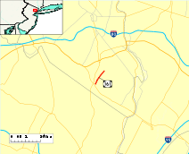
Route information Maintained by NJDOT Length: 1.10 mi[1] (1.77 km) Existed: 1953 – present Major junctions South end:  CR 602 in Clifton
North end: 
 CR 611 / CR 614 in Clifton
Highway system New Jersey State Highway Routes
Interstate and US←  Route 160
Route 162  →
→Route 161 (NJ 161) is a 1.10-mile (1.77 km) state highway in Clifton, New Jersey, United States, running along Clifton Avenue between Allwood Road (County Route 602) and Van Houten Avenue (County Route 614). Although it is a signed state highway, it does not connect to any other state-maintained roadways. However, the south terminus is aligned just northeast of the interchange of Route 3 and the Garden State Parkway (Interchange 153). The highway originated as Route S3 Spur, a suffixed spur of State Highway Route 3 to State Highway Route 6 (currently U.S. Route 46). The route was redesignated in 1953 as NJ 161.
Contents
Route description
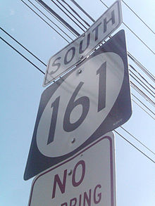 NJ 161's lone southbound shield at Van Houten Avenue
New Jersey Route 161 begins at the intersection of Clifton Avenue and Allwood Road (CR 602) in Clifton. The route passes a park and large commercial building at the southern terminus. From there, Route 161 continues northward, paralleling Richfield Terrace on the other side of the park. A short distance after, Route 161 provides a connector to Richfield Terrace on the northbound side of the highway, the park's divider known as Cross Street. The highway continues northward, intersecting with Richland Court, which provides access to local residential homes. The next intersection is with Joan Place, which serves a similar function to Richland Court.[2]
Soon after, Route 161 intersects with Saint Andrew's Boulevard, which also serves as the northern terminus of Richfield Terrace and connects the highway with County Route 609, Mount Prospect Avenue. Just past Saint Andrew's Boulevard Route 161 passes through a largely commercial section of Clifton with a heavy concentration of medical offices between Saint Andrew's Boulevard and the northern terminus as well as several other offices (including branches of Bank of America, Clifton Savings, and PNC Bank). Along the way Route 161 passes through several residential developments and Oak Ridge Park, located near the intersection of the Clifton Avenue and St. James Place. Route 161 terminates at an intersection with County Route 614 (Van Houten Avenue). The right-of-way of NJ 161 continues as Passaic County Route 611 (Clifton Avenue) towards downtown Clifton and remains mixed with commercial and residential properties until CR 611's intersection with Lexington Avenue, after which the remainder of Clifton Avenue to its terminus point with Randolph Avenue in the Botany section of town being residential.[2][3]
History
Route S3 was defined in 1929 to run from Route 3 in East Rutherford west to Route 6 (U.S. Route 46) in Clifton, (this is now part of Route 3). In 1942, the state took over the alignment and made it an unnumbered state highway was defined to run from the intersection of Clifton Avenue and Van Houten Avenue southwest to Route S3, which then ran along Allwood Road.[4] World War II delayed completion of Route S3 long enough for an alternate freeway route to be selected, and the part of Allwood Road that was taken over is no longer a state highway. In 1948, the route was assigned the number Route S3 Spur.[5] The number was changed to Route 161 in the 1953 renumbering,[6] and ever since then it has remained an isolated state highway.[7]
Major intersections
The entire route is in Clifton, Passaic County.
Mile[1] Destinations Notes 0.00 CR 602 (Allwood Road)Southern terminus of NJ 161 1.10 CR 611 / CR 614 (Van Houten Avenue)Northern terminus of NJ 161 1.000 mi = 1.609 km; 1.000 km = 0.621 mi See also
 U.S. Roads portal
 New Jersey portal
References
- ^ a b "NJ 161 Straight Line Diagrams". New Jersey Department of Transportation. 2008. pp. 1. http://www.state.nj.us/transportation/refdata/sldiag/00000161__-.pdf. Retrieved 2009-02-05.
- ^ a b Yahoo! Inc. Yahoo! Maps – overview map of NJ Route 161 (Map). Cartography by NAVTEQ. http://maps.yahoo.com/#mvt=h&lat=40.865181&lon=-74.159417&zoom=18&q1=40.852555%2C-74.173129&q2=40.865416%2C-74.161037. Retrieved 2009-02-06.
- ^ "Passaic CR 611 Straight Line Diagrams". New Jersey Department of Transportation. 2008. pp. 1. http://www.state.nj.us/transportation/refdata/sldiag/16000611__-.pdf. Retrieved 2009-02-05.
- ^ "77". ROUTE NO. . Beginning at the intersection of VanHouten avenue and Clifton avenue in the city of Clifton and from thence to connect with Route S-3.. New Jersey General Assembly. 1942. pp. 319.
- ^ "221". ROUTE NO. S-3, Spur. Providing a spur from Route No. S-3, in the vicinity of Broad street, thence in a northeasterly direction to the westerly end of Clifton avenue in the city of Clifton, county of Passaic.. New Jersey General Assembly. 1948. pp. 1054.
- ^ 1953 renumbering. New Jersey Department of Highways. http://en.wikisource.org/wiki/1953_New_Jersey_state_highway_renumbering. Retrieved July 31, 2009.
- ^ New Jersey Department of Transportation (2007). New Jersey Official Road Map (Map). Cartography by New Jersey Department of Transportation.
External links
Categories:- State highways in New Jersey
- Transportation in Passaic County, New Jersey
- Clifton, New Jersey


Wikimedia Foundation. 2010.