- Dauphiné Alps
-
Dauphiné Alps Range 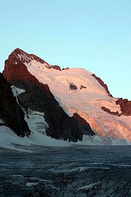 Barres des Écrins in early morning light, July 2006
Country France Borders on Cottian Alps, Graian Alps, Chartreuse Mountains Highest point Barre des Écrins - elevation 4,102 m (13,458 ft) - coordinates 44°55′23″N 6°21′36″E / 44.92306°N 6.36°E The Dauphiné Alps (French: Alpes du Dauphiné) are a group of mountain ranges in southeastern France, west of the main chain of the Alps. They are separated from the Cottian Alps in the east by the Col du Galibier and the upper Durance valley; from the western Graian Alps (Vanoise Massif) in the north-east by the river Arc; from the lower ranges Vercors Plateau and Chartreuse Mountains in the west by the rivers Drac and Isère. Many peaks rise to more than 10,000 feet (3,050 m), with Barre des Écrins (4,102 m) the highest.
Mountain ranges within the Dauphiné Alps include the Massif des Écrins (in the Parc national des Écrins), Belledonne, the Taillefer range and the mountains of Matheysine.
Peaks
The chief peaks of the Dauphiné Alps are:
Barre des Écrins 4102 meters (13,459 feet) Pic Felix Neff 3222 meters (10,571 feet) Meije 3987 meters (13,081 feet) Vieux Chaillol 3163 meters (10,378 feet) Ailefroide 3954 meters (12,972 feet) Tete de Vautisse 3162 meters (10,375 feet) Mont Pelvoux 3946 meters (12,946 feet) Grand Pinier 3120 meters (10,237 feet) Pic Sans Nom 3913 meters (12,838 feet) Pic de Parieres 3050 meters (10,007 feet) Pic Gaspard 3880 meters (12,730 feet) Mourre Froid 2996 meters (9830 feet) Pic Coolidge 3756 meters (12,323 feet) Grand Pic de Belledonne 2977 meters (9767 feet) Grande Ruine 3754 meters (12,317 feet) Rocherblanc (Sept Laux) 2931 meters (9617 feet) Rateau 3754 meters (12,317 feet) Taillefer 2861 meters (9387 feet) Les Bans 3669 meters (12,037 feet) Tete de l'Obiou 2793 meters (9164 feet) Montagne des Agneaux 3660 meters (12,008 feet) Pic du Frene 2810 meters (9219 feet) Sommet des Rouies 3634 meters (11,923 feet) Grand Ferrand 2761 meters (9059 feet) Aiguille du Plat de la Selle 3596 meters Pic de Bure (Aurouse) 2712 meters (8898 feet) Olan 3564 meters (11,735 feet) Pic Bonvoisin 3560 meters (11,680 feet) Aiguilles d'Arves (highest point) 3514 meters (11,529 feet) Grandes Rousses 3473 meters (11,395 feet) Roche de la Muzelle 3459 meters (11,349 feet) Sirac 3438 meters (11,280 feet) Passes
The chief passes of the Dauphiné Alps are:
name location type elevation (m/ft) Brèche de la Meije La Berarde to la Grave snow 3300/10,827 Brèche des Grandes Rousses Allemont to Clavans snow 3100/10,171 Brèche de Valsenestre Bourg d'Oisans to Valsenestre foot path 2634/8642 Col Bayard La Mure to Gap road 1246/4088 Col de la Casse Deserte La Berarde to La Grave snow 3510/11,516 Col de la Croix de Fer Bourg d'Oisans to Saint-Jean-d'Arves road 2062/6765 Col de la Croix Haute Grenoble to Serres and Gap road, railroad 1167/3829 Col de la Lauze Saint-Christophe-en-Oisans to La Grave snow 3543/11,625 Col de l'Alpe de Vénosc Vénosc to Les Deux Alpes bridle path 1660/5446 Col de la Muande St Christophe to the Val Gaudemar snow 3059/10,037 Col de la Muzelle St Christophe to Valsenestre foot path 2500/8202 Col d'Arsine La Grave to Le Monêtier-les-Bains bridle path 2400/7874 Col de la Temple La Berarde to Vallouise snow 3283/10,772 Col de la Vaurze Val Gaudemar to Valjouffrey foot path 2600/8531 Col de l'Eychauda Vallouise to Le Monêtier-les-Bains bridle path 2429/7970 Col de l'Infernet La Grave to Saint-Jean-d'Arves foot path 2690/8826 Col de Martignare La Grave to Saint-Jean-d'Arves foot path 2600/8531 Col des Aiguilles d'Arves Valloire to Saint-Jean-d'Arves snow 3150/10,335 Col des Avalanches La Berarde to Vallouise snow 3511/11,520 Col des Ecrins La Berarde to Vallouise snow 3415/11,205 Col des Prés Nouveaux Le Freney to Saint-Jean-d'Arves bridle path 2293/7523 Col des Quirlies Saint-Jean-d'Arves to Clavans snow 2950/9679 Col des Sept Laux Allevard to Bourg d'Oisans bridle path 2184/7166 Col des Tourettes Orcières to Châteauroux-les-Alpes bridle path 2580/8465 Col de Val Estrete Val Gaudemar to Champoléon foot path 2620/8596 Col de Vallonpierre Val Gaudemar to Champoléon foot path 2620/8596 Col d'Orcières Dormillouse to Orcières bridle path 2700/8859 Col d'Ornon Bourg d'Oisans to La Mure road 1360/4462 Col du Clot des Cavales La Berarde to La Grave snow 3128/10,263 Col du Galibier Col du Lautaret to Saint-Michel-de-Maurienne road 2658/8721 Col du Glacier Blanc La Grave to Vallouise snow 3308/10,854 Col du Glandon Bourg d'Oisans to La Chambre road 1951/6401 Col du Goleon La Grave to Valloire foot path 2880/9449 Col du Lautaret Briançon to Bourg d'Oisans road 2075/6808 Col du Loup du Valgaudemar Vallouise to the Val Gaudemar snow 3112/10,210 Col du Says La Berarde to the Val Gaudemar snow 3136/10,289 Col du Sele La Berarde to Vallouise snow 3302/10,834 Col du Sellar Vallouise to the Val Gaudemar snow 3067/10,063 Col Emile Pic La Grave to Vallouise snow 3502/11,490 Col Lombard La Grave to Saint-Jean-d'Arves snow 3100/10,171 Pas de la Cavale Vallouise to Champoléon dirt road 2740/8990 Categories:- Mountain ranges of the Alps
- Mountain ranges of France
Wikimedia Foundation. 2010.