- Matheysine
-
Matheysine is a French Natural region located in the Alps at the south of the Isère département. Its relief is a plateau surroundered by mountains. Matheysine is also called Plateau Matheysin.
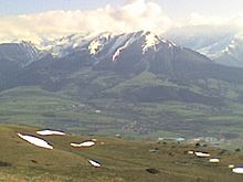 Matheysine from Sommet du Serre de l'Horizon, minor summit on Sénépy mountain
Contents
Geography
The Plateau Matheysin is located in the Isère département, 30 km south of Grenoble when heading to Gap. Included in the overall Taillefer massif, its average elevation is 1,000 m.

Belonging to south-Dauphiné, it is crossed over by the 45th parallel north and roughly matches the boundaries of the canton of La Mure. It is around 20 km long from north to south and around 13 km wide from east to west. At the south and at the west, the border of the plateau is marked by the Drac River, which defines the boundary with Trièves (at the south) and with the Vercors Plateau (at the west). At the north, the plateau ends at the Laffrey slope down to the Romanche valley at the elevation of 350m. At the east, the small mountain range including the summits of Grand Serre (elev. 2,141m.) and Tabor (elev. 2,389m.) marks the boundary with the Valbonnais canton.
Beside these mountains, the plateau is crossed over from north to south by the summits of the Connest Mountain (Peyrouse, Connex) and of the Sénépy. These mountains overlook a succession of four lakes of glacier origin called the Laffrey lakes. From north to south, these lakes are composed of the lac Mort, the Grand lac de Laffrey, the Petichet lake, the Pierre-Châtel lake. Close to the Pierre-Châtel lake can be found one of the so-called Seven Wonders of Dauphiné, a natural arch called the Pierre Percée.
La Mure is Matheysine's main city.
Climate
On this plateau, shaped by glaciers during the previous glacial periods and surrounded by high mountain ranges, the bise wind blows intensely, being frosty during Winter, but pleasant in Summer. Furthermore, at Winter time, the area can face heavy snowfalls.
For these reasons, Matheysine is being nicknamed Little Siberia.
History
Etymology
Have been successively used the names Mathaysana (11th century) and later Mattacena (14th century), which could possibly mean Matta "to be wet" and Cena "plateau". This depicts actually rather well both geography and climatic characteristics of the place. At last, before present name, Mataisine has also been used.
Matheysine's people are called Matheysins.
Napoléon I in Matheysine
The alpine road used by emperor Napoléon I, after having landed at Juan-les-Pins when coming back from Elba, crosses Matheysine. There, in a prairie located along the shore of Grand lac de Laffrey, at the place now called Prairie de la Rencontre (Meeting Prairie), the emperor and his troops (1,100 men led by 3 generals) met the royal army sent in order to stop them. Napoléon succeeded in rallying his opponents to his cause and could finally make it forward to Grenoble. An equestrian statue of Napoléon still reminds this event.
Coal mining
History of Matheysine has been strongly impacted by coal. This coal, of superior quality (anthracite), had been extracted starting at the beginning of the 19th century until the late 1990s. It has highly contributed to the reputation of the plateau.
Economic characteristics
Matheysine has been going through an economic reconversion since the planned decline and the cessation of the coal mining activity on the plateau.
New industries installations have been favoured through aids and fiscal easy terms. Tourism, as well as local craft industry, also help at renewing Matheysine's economic health.
Furthermore, the area presently experiences the arrival of urban people from the Grenoble built-up area, looking for more affordable real estate costs whilst keeping on working downtown. This phenomenon is partly contributing to a revival of the local trade.
External links
- Matheysine (French)
- Geology of Matheysine (French)
See also
Categories:

Wikimedia Foundation. 2010.