- Vercors Plateau
-
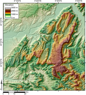
 DEM of the Vercors massif
The Vercors is a range of plateaux and mountains in the départements of Isère and Drôme in the French Prealps. It lies west of the Dauphiné Alps, from which it is separated by the rivers Drac and Isère. Cliffs at its eastern edge face the city of Grenoble.
The plateau's karstic area includes the famous Vercors Cave System which includes Gouffre Berger.
The Vercors has several resorts for cross-country skiing and for down-hill skiing. Villard-de-Lans is the biggest down-hill ski resort.
The region became noteworthy during World War II when the Maquis du Vercors led the French Resistance against the German occupation and established the Free Republic of Vercors in June and July 1944.
Principal summits
From north to south:
- le Moucherotte, 1,901 m, the summit which dominates Grenoble, most northerly of the massif ;
- Le Pic Saint-Michel, 1,966 m ;
- Roc Cornafion, 2,049 m ;
- les Arêtes du Gerbier, 2,109 m ;
- la Grande Moucherolle, 2,284 m ;
- la Petite Moucherolle, 2,156 m ;
- la Tête des Chaudières, 2,029 m ;
- les Rochers de la Balme, 2,063 m ;
- le Sommet de Malaval, 2,097 m ;
- Le Grand Veymont, 2,341 m, highest point of the massif ;
- le Mont Aiguille, 2,086 m, with its characteristic silhouette, its first ascent in 1492 was the birth of alpinism ;
- le Dôme ou Pié Ferré, 2,041 m, to the east of Die, in the Glandasse uplands.
See also
Coordinates: 44°58′N 5°25′E / 44.967°N 5.417°E
Wikimedia Foundation. 2010.

