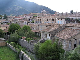
- Die, Drôme
-
Die


Administration Country France Region Rhône-Alpes Department Drôme Arrondissement Die Canton Die Mayor Georges Berginiat
(2008–2014)Statistics Elevation 367–1,841 m (1,204–6,040 ft)
(avg. 410 m/1,350 ft)Land area1 57.28 km2 (22.12 sq mi) Population2 4,358 (2008) - Density 76 /km2 (200 /sq mi) INSEE/Postal code 26113/ 26150 1 French Land Register data, which excludes lakes, ponds, glaciers > 1 km² (0.386 sq mi or 247 acres) and river estuaries. 2 Population without double counting: residents of multiple communes (e.g., students and military personnel) only counted once. Coordinates: 44°45′13″N 5°22′13″E / 44.7536111111°N 5.37027777778°E
Die (French pronunciation: [di]; Occitan: Diá [ˈdjɔ]) is a commune, former episcopal see, and sub-prefecture of the Drôme department in southeastern France.
Die is best known for the Clairette de Die, a sparkling wine. It was a county in the High Middle Ages.
Contents
Diocese of Die
Population
Historical population of Die, Drôme 1793 1800 1806 1821 1831 1836 1841 1846 1851 1856 3251 3978 3421 3509 3555 3900 3924 3865 3928 3912 1861 1866 1872 1876 1881 1886 1891 1896 1901 1906 3874 3762 3876 3841 3703 3823 3729 3681 3638 3651 1911 1921 1926 1931 1936 1946 1954 1962 1968 1975 3797 3232 3304 3241 3175 3184 3326 3546 4048 4062 1982 1990 1999 2008 3992 4230 4451 4358 See also
- Communes of the Drôme department
- Parc naturel régional du Vercors
References
External links
Categories:- Communes of Drôme
- Subprefectures in France
- Drôme geography stubs
Wikimedia Foundation. 2010.


