- Düsseldorf-Heerdt
-
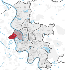
Heerdt is one of the older parts of the city of Düsseldorf. Heerdt and its neighbouring quarters Oberkassel, Niederkassel and Lörick on the left side of the river Rhine, opposite to the other districts of Düsseldorf and the central district.
Heerdt is connected to the centre of the city by three bridges, the Oberkassler Brücke, the Rheinkniebrücke and the Theodor-Heuss-Brücke. Cars, bikes and pedestrians can use all bridges, the Oberkassler Brücke is used by some tram and underground lines running between the districts on both sides of the river. There is a direct connection to the motorway 52 heading to Krefeld and Mönchengladbach. The tram lines U70 and U76 connect Heerdt with Meerbusch and Krefeld (and the central districts, too), the line U75 with Neuss.
Heerdt was mentioned first time in the 11th century. For a long while Heerdt was strongly connected to the neighbouring town of Neuss. At the end of the 19th century the construction of the first permanent bridge between Düsseldorf and Heerdt changed things. Heerdt became industrialised. Until today the structure of Heerdt shows the era of industrialisation, but there are a lot of relics of the old Heerdt, especially the old churches.
- Communal Administration, Statistics Office (German)
- Communal Administration, District Administration (German)
Districts of Düsseldorf District 1 · District 2 · District 3 · District 4 · District 5 · District 6 · District 7 · District 8 · District 9 · District 10 District 1: Altstadt · Derendorf · Golzheim · Carlstadt · Pempelfort · Stadtmitte | District 2: Düsseltal · Flingern-Nord · Flingern-Süd | District 3: Bilk · Flehe · Friedrichstadt · Hafen · Hamm · Oberbilk · Unterbilk · Volmerswerth | District 4: Heerdt · Lörick · Niederkassel · Oberkassel | District 5: Angermund · Kaiserswerth · Kalkum · Lohausen · Stockum · Wittlaer | District 6: Lichtenbroich · Mörsenbroich · Rath · Unterrath | District 7: Gerresheim · Grafenberg · Hubbelrath · Ludenberg | District 8: Eller · Lierenfeld · Unterbach · Vennhausen | District 9: Benrath · Hassels · Himmelgeist · Holthausen · Itter · Reisholz · Urdenbach · Wersten | District 10: Garath · Hellerhof
Coordinates: 51°13′42″N 6°42′57″E / 51.22833°N 6.71583°ECategories:- Urban districts and boroughs of Düsseldorf
- Düsseldorf
- North Rhine-Westphalia geography stubs
Wikimedia Foundation. 2010.


