- District 5, Düsseldorf
-
For other uses, see District 5.
Stadtbezirk 5 — District of Düsseldorf — Aerial view of Messe Düsseldorf in Stockum.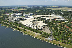
Visible in the background are Kaiserswerth (center) and Düsseldorf-Lohausen Airport (right)Location of District 5 shown in red
Country  Germany
State  North Rhine-Westphalia
City  Düsseldorf
Area – Total 50.96 km2 (19.7 sq mi) Population (December 2009[1]) – Total 32,481 – Density 637/km2 (1,649.8/sq mi)  St. Suitbertus in Kaiserswerth
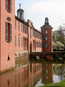 Schloss Kalkum in Kalkum
District 5 (German: Stadtbezirk 5) is a northern city district of Düsseldorf, the state capital of North Rhine-Westphalia, Germany. The district is location of Düsseldorf's International Airport. It is the largest district by land area, but also the least populated. The district covers an area of 50,96 square kilometres and (as of December 2009) has about 32,500 inhabitants.
Stadtbezirk 5 borders with the Düsseldorf districts 1 and 6 to the South, and - via a shared border across the Rhine - district 4 to the South-West. To the West - also across the Rhine - it borders with Rhein-Kreis Neuss. Further it shares borders with the city of Duisburg to the North, and Kreis Mettmann to the East.
Contents
Subdivisions
District 5 is made up of six Stadtteile (city parts):
# City part Population (2009) Area (km²) Pop. per km² 051 Düsseldorf-Stockum 5,060 6,70 755 052 Düsseldorf-Lohausen 4,009 11,66 344 053 Düsseldorf-Kaiserswerth 7,897 4,71 1,677 054 Düsseldorf-Wittlaer 7,654 6,91 1,108 055 Düsseldorf-Angermund 6,005 13,30 452 056 Düsseldorf-Kalkum 1.890 7,62 248 source: Amt für Statistik und Wahlen der Landeshauptstadt Düsseldorf (German) Places of interest
Arts, Culture and Entertainment
- Kaiserswerth Imperial Palace, Kaiserswerth
- Messegelände incl. multifunctional Esprit Arena, Stockum
Landmarks
- St. Suitbertus, Kaiserswerth
- Kalkum Palace, Kalkum
Parks and open spaces
- Nordpark
Transportation
The district is served by numerous railway stations and highway.[2] Düsseldorf International Airport is located in Lohausen, part of District 5. Stations include Düsseldorf Airport, Düsseldorf-Angermund and both Düsseldorf Stadtbahn light rail- and Rheinbahn tram-stations. The district can also be reached via Bundesautobahn 44, 52 and 59 as well as Bundesstraße 7 and 8.
Rhine bridges
 Flughafenbrücke
See also
References
- ^ Stadtbezirk 5, Landeshauptstadt Düsseldorf, 2009 (German)
- ^ Urban rail-transitmap Düsseldorf-Meerbusch, Verkehrsverbund Rhein-Ruhr
External links
 Media related to Districts of Düsseldorf at Wikimedia Commons
- Official webpage of the district (German)
Districts of Düsseldorf District 1 · District 2 · District 3 · District 4 · District 5 · District 6 · District 7 · District 8 · District 9 · District 10 District 1: Altstadt · Derendorf · Golzheim · Carlstadt · Pempelfort · Stadtmitte | District 2: Düsseltal · Flingern-Nord · Flingern-Süd | District 3: Bilk · Flehe · Friedrichstadt · Hafen · Hamm · Oberbilk · Unterbilk · Volmerswerth | District 4: Heerdt · Lörick · Niederkassel · Oberkassel | District 5: Angermund · Kaiserswerth · Kalkum · Lohausen · Stockum · Wittlaer | District 6: Lichtenbroich · Mörsenbroich · Rath · Unterrath | District 7: Gerresheim · Grafenberg · Hubbelrath · Ludenberg | District 8: Eller · Lierenfeld · Unterbach · Vennhausen | District 9: Benrath · Hassels · Himmelgeist · Holthausen · Itter · Reisholz · Urdenbach · Wersten | District 10: Garath · Hellerhof
Coordinates: 51°17′50″N 6°44′21″E / 51.29722°N 6.73917°ECategories:- Urban districts and boroughs of Düsseldorf
- North Rhine-Westphalia geography stubs


Wikimedia Foundation. 2010.