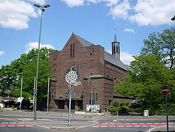
- Düsseldorf-Hassels
-
Hassels is an urban borough of Düsseldorf.
Its original name was "Hasselholt" what means hazelnut wood in older German language. In the 17th century only the first part of the name survived. Hassels belonged to the Knights of Eller. Later Hassels became part of the office of mayor of Benrath. In 1929 Hassels became - together with Benrath - part of Düsseldorf. Large settlements were built in Hassels in the 1920s, the 1950s and in the 1970s.
The old church from the 17th century no longer exists. Therefore Hassels has an early modern Catholic church, the St. Antonius Church from 1929. It was planned by Hermann Schagen. The Protestant Church was created by Kleiner in 1964. The Protestant school was in an old timbered house from 1804 for a long while.
This article is based on a translation of an article from the German Wikipedia.
Districts of Düsseldorf District 1 · District 2 · District 3 · District 4 · District 5 · District 6 · District 7 · District 8 · District 9 · District 10 District 1: Altstadt · Derendorf · Golzheim · Carlstadt · Pempelfort · Stadtmitte | District 2: Düsseltal · Flingern-Nord · Flingern-Süd | District 3: Bilk · Flehe · Friedrichstadt · Hafen · Hamm · Oberbilk · Unterbilk · Volmerswerth | District 4: Heerdt · Lörick · Niederkassel · Oberkassel | District 5: Angermund · Kaiserswerth · Kalkum · Lohausen · Stockum · Wittlaer | District 6: Lichtenbroich · Mörsenbroich · Rath · Unterrath | District 7: Gerresheim · Grafenberg · Hubbelrath · Ludenberg | District 8: Eller · Lierenfeld · Unterbach · Vennhausen | District 9: Benrath · Hassels · Himmelgeist · Holthausen · Itter · Reisholz · Urdenbach · Wersten | District 10: Garath · Hellerhof
Coordinates: 51°10′45″N 6°52′26″E / 51.17917°N 6.87389°ECategories:- Urban districts and boroughs of Düsseldorf
- Düsseldorf
- North Rhine-Westphalia geography stubs
Wikimedia Foundation. 2010.

