- New Smyrna Beach Historic District
-
New Smyrna Beach Historic District
 Houses in the district
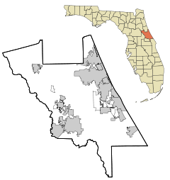
Location: New Smyrna Beach, Florida Coordinates: 29°1′30″N 80°55′27″W / 29.025°N 80.92417°WCoordinates: 29°1′30″N 80°55′27″W / 29.025°N 80.92417°W Area: 1,000 acres (4.0 km2) NRHP Reference#: 90000714 Added to NRHP: April 26, 1990 The New Smyrna Beach Historic District is a U.S. historic district (designated as such on April 26, 1990) located in New Smyrna Beach, Florida. The district is bounded by Riverside Drive, U.S. 1, Ronnoc Lane, and Smith Street. It contains 312 historic buildings.
External links
U.S. National Register of Historic Places in Florida Lists by county Alachua • Baker • Bay • Bradford • Brevard • Broward • Calhoun • Charlotte • Citrus • Clay • Collier • Columbia • DeSoto • Dixie • Duval • Escambia • Flagler • Franklin • Gadsden • Gilchrist • Glades • Gulf • Hamilton • Hardee • Hendry • Hernando • Highlands • Hillsborough • Holmes • Indian River • Jackson • Jefferson • Lafayette • Lake • Lee • Leon • Levy • Liberty • Madison • Manatee • Marion • Martin • Miami-Dade • Monroe • Nassau • Okaloosa • Okeechobee • Orange • Osceola • Palm Beach • Pasco • Pinellas • Polk • Putnam • Santa Rosa • Sarasota • Seminole • St. Johns • St. Lucie • Sumter • Suwannee • Taylor • Union • Volusia • Wakulla • Walton • Washington

Lists by city Other lists Keeper of the Register • History of the National Register of Historic Places • Property types • Historic district • Contributing property Categories:- National Register of Historic Places in Volusia County, Florida
- Historic districts in Florida
- Florida Registered Historic Places district stubs
Wikimedia Foundation. 2010.

