- Cheesequake State Park
-
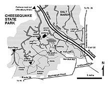 Map of Cheesequake State Park in Old Bridge, New Jersey
Cheesequake State Park is a 1,274-acre (5.16 km2) state park located in Old Bridge Township, Middlesex County, New Jersey in the United States.
The New Jersey Legislature allocated $100,000 in 1937 to purchase property for this state park. The state first acquired a 250 acre tract of farmland and a Civil War era mansion from the Favier brothers in January 1938. Additional lands were acquired. The Civil Conservation Corps, part of the Works Progress Administration, helped develop the property. The park was opened in June 1940.[1] [2] [3] It is operated and maintained by the New Jersey Division of Parks and Forestry and is part of the New Jersey Coastal Heritage Trail Route.
The name Cheesequake was derived from the Lenape Native American word Cheseh-oh-ke, meaning "upland"[4] or "upland village".[5]
Contents
Geography, flora, and fauna
The park's lowlands consist of freshwater and saltwater marsh and a tidal estuary near the mouth of Cheesequake Creek on the Raritan Bay. It also includes hills of Northeastern hardwood forest, open fields, and a white cedarswamp. It includes a small parcel of Atlantic coastal pine barrens, consisting of pine forest in sandy soil, an isolated section of the much larger New Jersey Pine Barrens. It also includes the 6-acre (24,000 m2) Hooks Creek Lake, a freshwater lake where recreational fishing includes catches of trout, largemouth bass, catfish, and sunfish. Crabbing is also available at the park.
Facilities, activities, and trails
The park includes an interpretive center and five marked trails for both hiking and mountain biking that run throughout the wooded hills and across long wooden bridges across marshland. The park has designated camping areas available by reservation. Swimming and boating are summertime activities, while sledding, cross-country skiing, and snowshoeing are available in wintertime.
The Garden State Parkway runs through the park near Exit 120 but offers no direct access. A road runs underneath the Parkway to connect the northern and southern sides of the park. Some of the park is visible from the Parkway. Aberdeen-Matawan (NJT station) is about two miles east of the park.
See also
References
- ^ "A Century of Forest Stewardship in New Jersey, 1905 - 2005," by Kevin Wright, p 52, 2005, accessed 31 December 2010
- ^ Matawan Journal, 27 January 1938, p 1, "Purchase Land For Cheesequake Park", accessed 31 December 2010
- ^ "The Civilian Conservation Corps: A Legacy Lives On In New Jersey's State Parks", DEP Focus, Fall 2008, Vol 1,Issue 2, p 1, published by the NJ Dept of Environmental Protection, accessed 31 December 2010
- ^ CHEESEQUAKE STATE PARK, accessed November 17, 2006
- ^ Cheesequake State Park: Cheesequake Cedar Swamp , accessed November 17, 2006
External links
- NJDEP Division of Parks and Forestry page on the park
- US Geological Survey page on the park
- NY-NJTC: Cheesequake State Park Trail Details and Info
Categories:- New Jersey state parks
- Old Bridge Township, New Jersey
- Parks in Middlesex County, New Jersey
- Raritan Bayshore

Wikimedia Foundation. 2010.