- Ailsa Craig
-
For the Canadian town, see Ailsa Craig, Ontario. For the islet in the Antarctic, see Ailsa Craig (South Orkney Islands).
Ailsa Craig Location 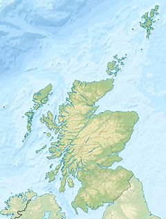
 Ailsa Craig
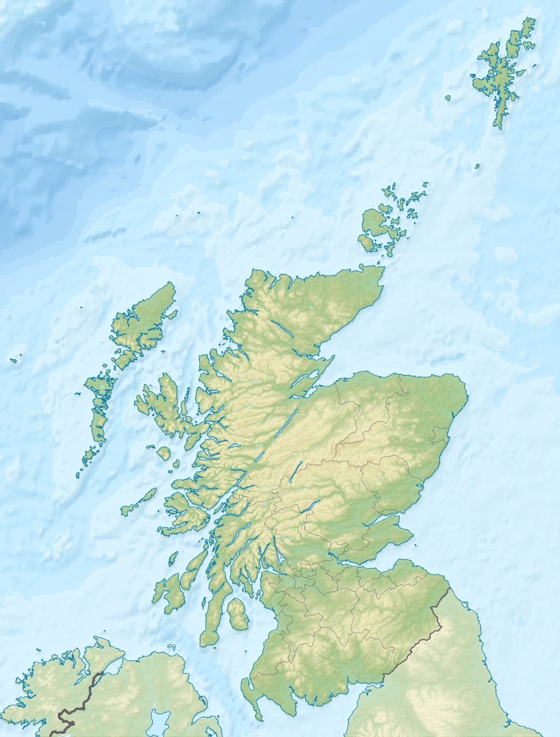
Ailsa Craig shown within Scotland OS grid reference NX019997 Names Gaelic name Creag Ealasaid Meaning of name Elizabeth's rock or Fairy rock Area and summit Area 0.38 sq.mi. (0.99 km²) Area rank 149= Highest elevation 1,110 ft (338 m)
(a Marilyn)Population Population 0 Groupings Island group Firth of Clyde Local Authority South Ayrshire 

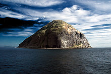
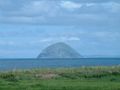
References [1][2][3][4] If shown, area and population ranks are for all Scottish islands and all inhabited Scottish islands respectively. Population data is from 2001 census. Ailsa Craig (Scottish Gaelic: Creag Ealasaid) is an island in the outer Firth of Clyde, Scotland where blue hone granite is quarried to make curling stones. "Ailsa" is pronounced "ale-sa", with the first syllable stressed. The now uninhabited island is formed from the volcanic plug of an extinct volcano.
The island was a haven for Catholics during the Scottish Reformation in the 16th century, but is today a bird sanctuary, providing a home for huge numbers of gannets and an increasing number of puffins.
Contents
Geography
The island is located approximately 10 miles (16 km) west of Girvan. Two miles (3 km) in circumference and rising to 1,110 feet (340 m), the island consists entirely of the volcanic plug of an extinct volcano that might have been active about 500 million years ago.[5]
 Ailsa Craig from the north
It is part of the administrative district of South Ayrshire, in the ancient parish of Dailly.
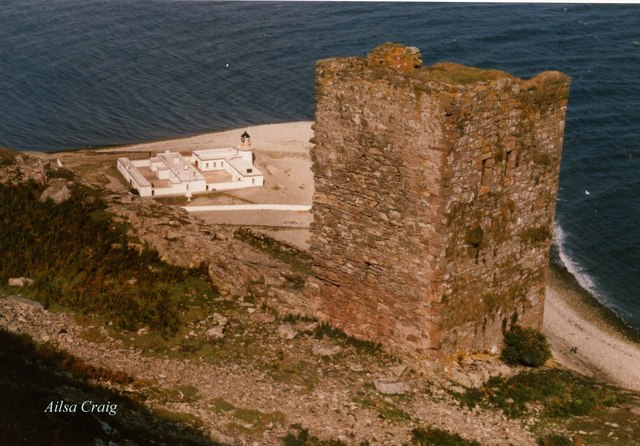
The lighthouse on its east coast faces the Scottish mainland, and a ruined keep of uncertain origins is perched on the hillside above.
History
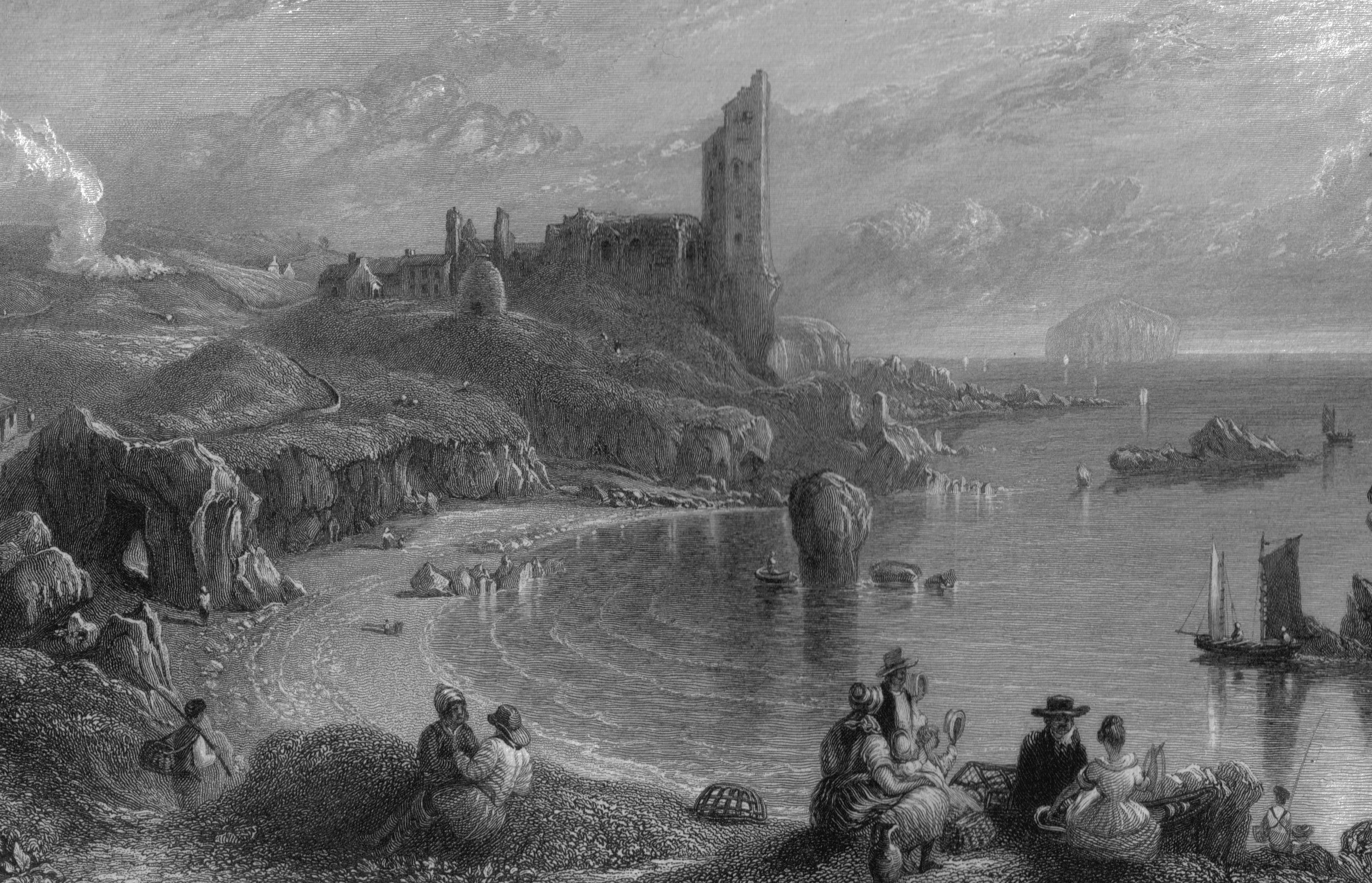
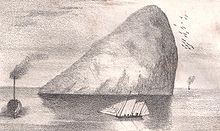 Ailsa Craig in the 1840s
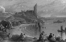 Ailsa Craig in the background with Dunure in 1840
Ailsa Craig was a haven for Roman Catholics during the Scottish Reformation. In 1597 the Catholic supporter Hugh Barclay of Ladyland took possession of Ailsa Craig, which he was intent on using as a provisioning and stopping off point for a Spanish invasion which would re-establish the Catholic faith in Scotland. He was discovered by the Protestant minister Andrew Knox and thereafter either tried to escape or deliberately drowned himself in the sea off Ailsa Craig.[6]
The island was used as a prison during the 18th-19th century.
In 1831, the twelfth earl of Cassillis became first Marquess of Ailsa, taking the title from the Craig, which was his property.
From the mid-19th to mid-20th centuries, the island was quarried for its rare type of micro-granite with riebeckite (known as "Ailsite") which is used to make curling stones. As of 2004, 60 to 70% of all curling stones in use were made from granite from the island.[7] The floor of the Chapel of the Thistle in St Giles Cathedral, Edinburgh is also made of this rock.
Ailsa Craig is now uninhabited, the lighthouse having been automated in 1990.[8] Ailsa Craig and its lighthouse feature extensively in Peter Hill's book Stargazing: Memoirs of a Young Lighthouse Keeper. Though quarry blasting is no longer allowed, loose granite rock from the island has been recently used for manufacture into curling stones by the Kays of Scotland company.[9] The island is now a bird sanctuary, leased by the RSPB until 2050.[10] Huge numbers of gannets nest here and following a pioneering technique to eradicate the island's imported population of rats a growing number of puffins are choosing to return to the Craig from nearby Glunimore and Sheep Islands.
The island belongs to the 8th Marquess of Ailsa, 19th Earl of Cassillis. In May 2011 it was announced the island was for sale.[11]
Etymology
An early reference to the rock is made by Sir Donald Monro, Archdeacon of the Isles who referred to the rock as "Elsay" in the 16th century.[12] The modern name of the island is an anglicisation of the Gaelic, Aillse Creag meaning "fairy rock".[2] An alternative Gaelic name is Creag Ealasaid meaning "Elizabeth's rock".[2][4] The first element, Aillse may represent Allt Shasann, "cliff of the English", mentioned in the Book of Leinster as Aldasain.[13][14]
The island is sometimes known as "Paddy's Milestone",[4][15] being approximately the halfway point of the sea journey from Belfast to Glasgow, a traditional route of emigration for many Irish labourers coming to Scotland to seek work.
As a result of being the most conspicuous landmark in the channel between Ireland and Scotland, the island is known by a number of different names;
- A' Chreag: "the rock"[4]
- Creag Alasdair: "Alasdair's rock"[2]
- Ealasaid a' Chuain: "Elizabeth of the ocean"[4]
- Alasan[4]
- Carraig Alasdair: "Alasdair's Rock", (used in the Madness of Sweeney the tale of a legendary king of Ireland).[2]
The Bass Rock is sometimes nicknamed "the Ailsa Craig of the East",[16] although its prominence in the Firth of Forth is not as great as that of Ailsa Craig in the Firth of Clyde.
In the arts
In April 2009, Northern Irish singer/songwriter, Foy Vance, released the EP 'Portraits Of The Artist', which contained a song titled 'Portraits of Ailsa Craig'.[17]
Gallery
-
Ailsa Craig over the sea
-

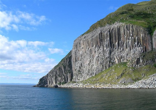
Spectacular columnar rock formations on the south-west side of the island
-
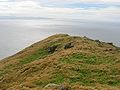
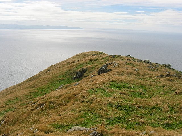
Summit ridge (338 m)
-

Lighthouse and Castle
Notes
- ^ 2001 UK Census per List of islands of Scotland
- ^ a b c d e Haswell-Smith (2004) p.2
- ^ Ordnance Survey
- ^ a b c d e f Mac an Tàilleir (2003) p. 3
- ^ Ailsa Craig Retrieved on 2007-10-17
- ^ Robertson, George (1823), A Genealogical Account of the Principal Families in Ayrshire, more particularly in Cunninghame. Vol.1. Pub. Irvine: Cunninghmae press. pp. 72 -73.
- ^ National Geographic Retrieved on 2009-07-19
- ^ Northern Lighthouse Board - Automation of lighthouse Retrieved on 2008-01-28
- ^ Kays of Scotland website Retrieved on 2009-07-19
- ^ "RSPB stress importance of Ailsa Craig, but are not in negotiations to purchase iconic landmark". RSPB. Retrieved 14 July 2011.
- ^ "Ailsa Craig island in Firth of Clyde put up for sale". BBC News. Retrieved 14 July 2011.
- ^ Monro (1549) no. 2
- ^ Clancy (2008) pp. 33–34
- ^ Watson (1926) p. 173
- ^ PADDY'S MILESTONE 1947 Film. ssa.nls.uk.
- ^ "The Bass Rock". History of Leith. http://www.leithhistory.co.uk/2007/11/29/the-bass-rock/. Retrieved 20 October 2009.
- ^ "Portraits of the Artist" foyvance.com. Retrieved 19 Feb 2011.
References
- Clancy, Thomas Owen (2008), "The Gall-Ghàidheil and Galloway", Journal of Scottish Name Studies 2: 19–50, ISSN 1747-7387
- Haswell-Smith, Hamish (2004). The Scottish Islands. Edinburgh: Canongate. ISBN 1841954543.
- Iain Mac an Tàilleir (2003). "Placenames" (pdf). Pàrlamaid na h-Alba. http://www.scottish.parliament.uk/vli/language/gaelic/pdfs/placenamesA-B.pdf. Retrieved 23 July 2010.
- Monro, Sir Donald (1549) A Description Of The Western Isles of Scotland. Appin Regiment/Appin Historical Society. Retrieved 3 March 2007. First published in 1774.
- Watson, W.J., The Celtic Place-Names of Scotland, (Edinburgh, 1926) reprinted, with an Introduction, full Watson bibliography and corrigenda by Simon Taylor (Edinburgh, 2004)
 This article incorporates text from a publication now in the public domain: Chisholm, Hugh, ed (1911). Encyclopædia Britannica (11th ed.). Cambridge University Press.
External links
- Photo Tour of Trip to the Island
- Entry on the Maybole Home Page
- Ailsa Craig Index — computer-generated virtual panoramas
- Pictures of Ailsa Craig
Settlements Former burghs: Ballantrae • Girvan • Maybole
Others: Auchencrosh • Balkissock • Bargany • Barr • Colmonell • Crosshill • Dailly • Drumshang • Dunure • Greenan • Kirkmichael • Kirkoswald • Maidens • Minishant • Old Dailly • Patna • Pinmore • Pinwherry • Smyrton • StraitonAdministration National subdivisions: Ayrshire and Arran lieutenancy area • Carrick earldom • Kyle and Carrick local government district • Sheriffdom and County of Ayr • South Ayrshire Council area
Parliamentary seats (Scotland): Carrick, Cumnock and Doon Valley
Parliamentary seats (UK): Ayrshire (1708–1868) • South Ayrshire (1868–1983) • Carrick, Cumnock and Doon Valley (1983–2005) • Ayr, Carrick and Cumnock (2005–)Culture Geography Islands: Ailsa Craig
Lochs: Craigdow Loch • Loch Bradan • Loch Doon • Loch Dornal • Loch Finloch • Loch Goosey • Loch Spaig • Loch Spallander • Loch Spouts
Rivers: River Doon • River Stinchar • Water of App • Water of Girvan • Water of TigHistory Heritage sites: Blairquhan Castle • Crossraguel Abbey • Culzean Castle • Dinvin Motte • Dunduff Castle • Dunure Castle • Glenapp Castle • Greenan Castle • Kirkoswald Parish Church • Knockdolian • Maybole Collegiate Church • Penkill Castle • Turnberry Castle
People: Abbots of Crossraguel • Clan Kennedy • Earls or mormaers of Carrick • Marquesses of Ailsa and their predecessorsSport Transport Railway lines: Girvan and Portpatrick Junction Railway • Maybole and Girvan Railway
Railway stations: Barrhill railway station • Girvan railway station • Maybole railway station
Roads: A77 • A714Categories:- Islands of the Clyde
- Marilyns of Scotland
- Mountains and hills of the Scottish islands
- Uninhabited islands of Scotland
- Sites of Special Scientific Interest in Cumnock and Kyle
- Volcanic plugs of Scotland
- Cambrian volcanoes
- Geography of South Ayrshire
- Protected areas of South Ayrshire
- Royal Society for the Protection of Birds reserves in Scotland


Wikimedia Foundation. 2010.