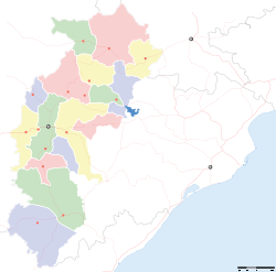
- Dongargaon
-
Dongargaon — city — Coordinates 20°58′N 80°51′E / 20.97°N 80.85°ECoordinates: 20°58′N 80°51′E / 20.97°N 80.85°E Country India State Chhattisgarh District(s) Rajnandgaon Population 11,571 (2001[update]) Sex ratio 990 ♂/♀ Time zone IST (UTC+05:30) Area
• 304 metres (997 ft)
- For the village in Maharashtra, see Villages of Taluka Niphad.
Dongargaon is a town and a nagar panchayat in Rajnandgaon district in the state of Chhattisgarh, India.
Contents
Geography
Dongargaon is located at 20°58′N 80°51′E / 20.97°N 80.85°E[1]. It has an average elevation of 304 metres (997 feet).
Politics
Famous politician here are Dr.Raman Singh. CM of Chattisgarh. played a vital role in the development of the town.
Demographics
As of 2001[update] India census[2], Dongargaon had a population of 11,571. Males constitute 51% of the population and females 49%. Dongargaon has an average literacy rate of 78%, higher than the national average of 59.5%: male literacy is 78% and, female literacy is 74%. In Dongargaon, 14% of the population is under 6 years of age. Today Dongargaon is not a village its growing fast and have a lot of things you can only find in a developed town. This is called CM constituency.
References
- ^ Falling Rain Genomics, Inc - Dongargaon
- ^ "Census of India 2001: Data from the 2001 Census, including cities, villages and towns (Provisional)". Census Commission of India. Archived from the original on 2004-06-16. http://web.archive.org/web/20040616075334/http://www.censusindia.net/results/town.php?stad=A&state5=999. Retrieved 2008-11-01.
Cities and towns in Rajnandgaon district Rajnandgaon Ambagarh Chowki · Chhuikhadan · Dongargaon · Dongragarh · Gandai · Khairagarh · Rajnandgaon
Cities and towns
in other districts[[it:Dongargao
Categories:- Cities and towns in Rajnandgaon district
- Chhattisgarh geography stubs
Wikimedia Foundation. 2010.


