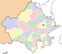
- Dariba, Rajasthan
-
Dariba — city — Coordinates 24°57′N 74°08′E / 24.95°N 74.13°ECoordinates: 24°57′N 74°08′E / 24.95°N 74.13°E Country India State Rajasthan District(s) Rajsamand Population 2,832 (2001[update]) Time zone IST (UTC+05:30) Area
• 479 metres (1,572 ft)
Dariba is a census town in Rajsamand district in the state of Rajasthan, India.
Geography
Dariba is located at 24°57′N 74°08′E / 24.95°N 74.13°E[1]. It has an average elevation of 479 metres (1571 feet).
Demographics
As of 2001[update] India census[2], Dariba had a population of 2832. Males constitute 53% of the population and females 47%. Dariba has an average literacy rate of 84%, higher than the national average of 59.5%: male literacy is 89% and, female literacy is 79%. In Dariba, 8% of the population is under 6 years of age.Dariba is an important zinc-lead-silver mining region of Rajasthan.
References
- ^ Falling Rain Genomics, Inc - Dariba
- ^ "Census of India 2001: Data from the 2001 Census, including cities, villages and towns (Provisional)". Census Commission of India. Archived from the original on 2004-06-16. http://web.archive.org/web/20040616075334/http://www.censusindia.net/results/town.php?stad=A&state5=999. Retrieved 2008-11-01.
Rajsamand Cities and towns
in other districtsAjmer · Alwar · Banswara · Baran · Barmer · Bharatpur · Bhilwara · Bikaner · Bundi · Chittorgarh · Churu · Dausa · Dholpur · Dungarpur · Hanumangarh · Jaipur · Jaisalmer · Jalore · Jhalawar · Jhunjhunu · Jodhpur · Karauli · Kota · Nagaur · Pali · Pratapgarh · Sawai Madhopur · Sikar · Sirohi · Sri Ganganagar · Tonk · Udaipur
Categories:- Cities and towns in Rajsamand district
- Rajasthan geography stubs
Wikimedia Foundation. 2010.


