- Chengamanad
-
Chengamanad — town — Coordinates 10°09′54″N 76°21′44″E / 10.1650700°N 76.362340°ECoordinates: 10°09′54″N 76°21′44″E / 10.1650700°N 76.362340°E Country India State Kerala District(s) Ernakulam Population 29,775 (2001[update]) Time zone IST (UTC+05:30) Codes-
• Telephone • +0484 • Vehicle • KL-41
Chengamanad (Malayalam: ചെങ്ങമനാട്) is also called as [MIC CITY]] in Greater Cochin Area in Ernakulam district in the state of Kerala, India. It is situated on the banks of the river Periyar.
Contents
Demographics
As of 2001[update] India census,[1] Chengamanad had a population of 29,775. Males constitute 49% of the population and females 51%. Chengamanad has an average literacy rate of 80%, higher than the national average of 59.5%; with male literacy of 82% and female literacy of 78%. 11% of the population is under 6 years of age.
Origin of the name - Chengamanad
According to legends the place derives its name from Jangama Muni who is said to have done penance in a cave in the munikkal Guhalaya. The place was initially called Jangamanad which later became chengamanad. Another account says that the name Chengamand is due to the special kind of soil called Chengal in malayalam. It is said that once three legendary people,Mathayi, Thomachan and Pylee, whose orgin was never known till date, stayed there for a month to attain enlightment. It is believed that they will come again to give peace and prosperity to its people.
Chengamanad Mahadeva Temple
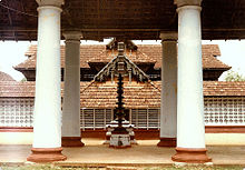 Chengamanad Mahadeva temple - Front View
The Chengamand Mahadeva temple is the centre of attraction in Chengamanad and is one of the important shiva temples in Ernakulam district. The main deity, Shiva is in the form of Kirata Murthi facing East. The shrine of Shree Parvathi and Ganapathi faces towards west and south respectively.
The temple is owned by 10 Brahmin families. They are “Thaliyal Mana, Makaramattathu Mana, Maliekkal Mana, Padamattathu Mana, Padappa Mana, Vaippan Mana, Edaprambilli Mana, Mozhully Mana, Potty Mana, and Aazhvancherry Thamprakkal”.
These families are spread out various places and they can't manage the temple properly. So they are handed over the management authority to the “Urazhma Devaswam Board”. As of now, the temple is functioning by the “Urazhma Devaswam Board” and a private committee, generated by local people.
The annual festival of the temple comes in Dhanu. It begins with kodiyettu on Chathayam day, lasts for 10 days and ends on Thiruvathira star. So many art forms like 'Kadhakali', 'Ottamthullal', Paadakam', etc. are performed during the festival days. The most important vazhipaadu in the festival days is 'Ulsavabali Dharsanam'. At the last day(Aarattu) of the festival, there is a fantastic ezhunnellippu with 7 elephant and great 'Panchavaadhyam' and 'Paandimelam' in the morning and night. The annual festival ends with a marvelous firework.
The temple needs urgent restoration work estimated to cost around Rs. 75,50,000.00/-. The temple administration in association with the local people is on a massive fund rising program to meet this expense. Devotees and well-wishers are requested to contribute liberally towards this divine venture.
For more details the temple administration can be contacted at the following address.
Places of Worship
- Munikkal Guhalaya Temple
The other center of attraction in Chengamand is the Munikkal temple. It is a small shrine dedicated to Load Subramanyan (son fo Shiva). The temple is situated on a large rock resembling the back of an elephant.
- St. Antony's Church
The Roman Catholic Church in the Name of St. Antony is another attraction in the place. Holy Feast of the Church is celebrated on the last week of January.
- Palaprassery Juma Masjid
Palaprassery Juma Masjid which represents the Muslim community of western area is another landmark. The masjid situates 1 km away from Chengamanad Junction on the Parur road.
Transport
Chengamanad is 10 km from Aluva by road on the Alwaye-Mala bus route. The nearest railway stations are Aluva( 10 km) and Angamaly (7 km). The nearest airport is Cochin international airport, 3 km from chengamanad.
References
- ^ "Census of India 2001: Data from the 2001 Census, including cities, villages and towns (Provisional)". Census Commission of India. Archived from the original on 2004-06-16. http://web.archive.org/web/20040616075334/http://www.censusindia.net/results/town.php?stad=A&state5=999. Retrieved 2008-11-01.
Alengad · Aluva · Ambalamugal · Angamaly · Arookutty · Azhikode · Chellanam · Chendamangalam · Chengamanad · Cherai · Cheranallur · Cherthala · Choornikkara · Chottanikkara · Chittoor · Edapally · Edathala · Elamkulam · Eloor · Ezhikkara · Fort Kochi · Kadamakkudy · Kadavanthra · Kadungallur · Kakkanad · Kalamassery · Kaloor · Karukutty · Kizhakkambalam · Kodungallur · Kolenchery · Kumbalam · Kumbalangy · Maliankara · Marine Drive · Moothakunnam · Mulavukad · Nedumbassery · Njarackal · North Paravur · Pachalam · Palarivattom · Palluruthy · Panampilly Nagar · Panayikulam · Pathalam · Pattimattom · Perumbavoor · Puthencruz · Puthuvype · Thiruvankulam · Thoppumpady · Thrikkakara · Thuravoor Thekku · Thuruthipuram · Vaduthala · Vallarpadam · Varapuzha · Vazhakulam · Vennala · Vypin · Vyttila · Willingdon Island ·
External links
Cities and towns in Ernakulam district Ernakulam Aluva · Angamaly · Ayyampuzha · Chendamangalam · Chengamanad · Cheranallur · Choornikkara · Chottanikkara · Chowwara · Edathala · Eloor · Ernakulam · Kadamakkudy · Kakkanad · Kalamassery · Kanayannur · Kochi · Kolenchery · Kothamangalam · Muvattupuzha · Koothattukulam · Piravom · Kottuvally · Kumbalam · Kunnathunad · Kureekkad · Malayattoor · Maradu · Mulavukad · North Paravur · Perumbavoor · Puthuvypin · Thiruvankulam · Thrikkakara · Thrippunithura · Varappuzha · Vazhakkala · Willingdon Island ·
Cities and towns
in other districtsAlappuzha · Idukki · Kannur · Kasargod · Kollam · Kottayam · Kozhikode · Malappuram · Palakkad · Pathanamthitta · Thiruvananthapuram · Thrissur · Wayanad
Categories:- Neighbourhoods of Kochi
- Cities and towns in Ernakulam district
- Suburbs of Kochi city
-


Wikimedia Foundation. 2010.