- Coll
-
Coll Location 
OS grid reference NM207584 Names Gaelic name Cola Pronunciation [kʰɔlˠ̪ə] (  listen)
Meaning of name Hazel Area and summit Area 7,685 hectares (29.7 sq mi)[1] Area rank 18 Highest elevation Ben Hogh 104 metres (341 ft)[1] Population Population 164 Population rank 35 out of 97 Main settlement Arinagour[1] Groupings Island group Mull Local Authority Argyll and Bute 

References [1][2][3] If shown, area and population ranks are for all Scottish islands and all inhabited Scottish islands respectively. Population data is from 2001 census. 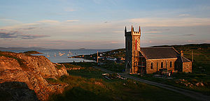 View of Arinagour
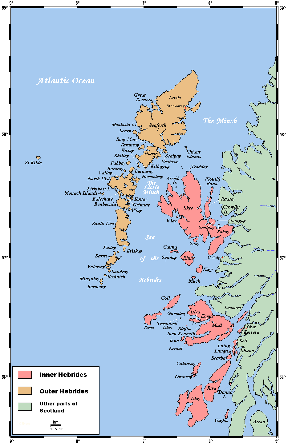
Coll (Scottish Gaelic: Cola)[4] is a small island, west of Mull in the Inner Hebrides of Scotland. Coll is known for its sandy beaches, which rise to form large sand dunes, for its corncrakes, and for Breachacha Castle.
Contents
Geography and geology
Coll is about 13 miles (20.9 km) long by 3 miles (4.8 km) wide and has a population of fewer than 200. Coll's sandy beaches rise to form large sand dunes. The highest point on Coll is Ben Hogh in the south west of the island, which rises to a height of 341 feet (104 m).
Settlements
- Acha (Scottish Gaelic: An t-Achadh).[5] A crofting settlement located 3 miles (4.8 km) south-west of Arinagour.[6]
- Arileod (Scottish Gaelic: Àirigh Leòid).[5] Located on the west coast; 4 miles (6.4 km) south-west of Arinagour.[7]
- Arinagour (Scottish Gaelic: Àirigh nan Gobhar).[5] The main settlement on the island; located at the head of Loch Eatharna, on the east coast.[8]
- Arnabost (Scottish Gaelic: Àrnabost).[5] Located 2 miles (3.2 km) miles north-west of Arinagour; it is the junction for travel between Sorisdale, Clabhach and Arinagour.[9]
- Ballyhaugh (Scottish Gaelic: Baile Hogh).[5] Located on the northern part of Hough Bay; 3 miles (4.8 km) west of Arinagour.[10]
- Bousd (Scottish Gaelic: Babhsta).[5] Located 4 miles (6.4 km) north-east of Arinagour.[11]
- Clabhach (Scottish Gaelic: A' Chlabaich).[12] Located on the north-west coast; 3 miles (4.8 km) north-west of Arinagour.[13]
- Crossapol (Scottish Gaelic: Crosabol).[12] Located on the south-west coast.[14]
- Totronald (Scottish Gaelic: Tobhta Raghnaill). Located on the west coast; 4 miles (6.4 km) southwest of Arinagour.[15]
- Uig (Scottish Gaelic: Ùig).[12] Located 0.5 miles (0.80 km) north-east of the head of Loch Breachacha.[16]
Transportation
There are only two main roads on Coll. The main hub of the island is the island's largest settlement—Arinagour. About 1.5 km (1 mi) south of Arinagour is the Caledonian MacBrayne ferry terminal.[17] The ferry travels from Oban to Coll to Tiree; and a return trip from Tiree, to Coll, to Oban.[18][18] The ferry between Oban and Castlebay on Barra goes via Coll and Tiree once a week.
The airport on the island, (IATA: COL) is located between Uig and Arileod. Highland Airways who originally operated the route to Oban went into administration in 2010,[19] but a new operator, Hebridean Air Services now operates the route under a PSO with flights to Oban, Tiree and Colonsay. The aircraft used for the flights are a BN2 Islander (G-HEBS). Hebridean headquarters are at Cumbernauld Airport, North Lanarkshire.
History
Coll was home to a branch of the Clan Maclean for 500 years, not all of which were peaceful. In 1590 the Macleans of Duart invaded their cousins on Coll with the intention of taking the island for themselves. A battle was fought at Breachacha Castle where the Coll clan overwhelmed the Duarts, chopped off their heads and threw them in the stream, which is still known as "the stream of the heads". The Macleans of Coll retained their baronial fief and Castle of Breachacha until 1848 when Alexander Maclean of Coll emigrated to Natal, South Africa where he died unmarried.
Coll, like other Hebridean islands, has several crannógs (artificial islands) located in some of its lochs. One such crannog is Dun Anlaimh, which is thought to date to at least the later Middle Ages. Local tradition states that the dun was the fortress of a Norse chieftain who was defeated in battle by the Macleans.
Breachacha Castle on the south coast dates from the 15th century. It was restored by the Project Trust,[20] a gap year organisation that sends school leavers abroad for a year's voluntary work. They send 17-19 year olds on a whole year abroad, and have extensive selection and training weeks.[21] An 18th century mansion house stands nearby.
The population of Coll was much higher in the past. In the late 18th century there were about 1,000 people supported by agriculture and fishing.[1] During the Highland Clearances of the 1830s and 1840s, half the population left, many of them moving to Australia, Canada or South Africa.
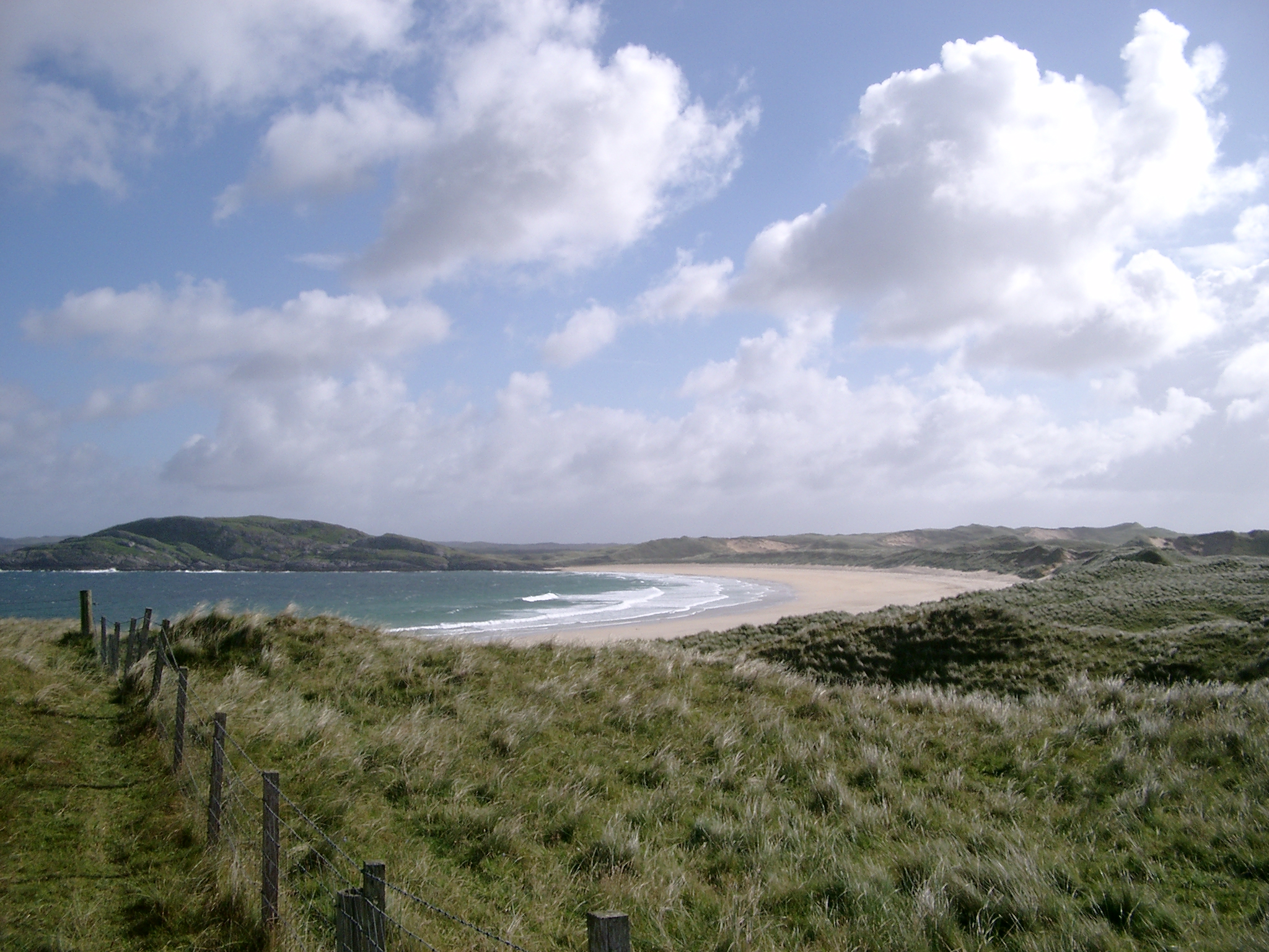
 Traigh Feall (Feall Beach), Isle of Coll
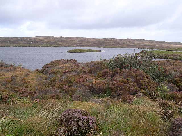
Branches Maclean of Duart · Maclean of Coll · Maclean of Ardgour Lands Ardgour · Coll · Castles Duart Castle · Glensanda Castle Septs Beath · Beaton · Black · Garvie · Lean · MacBeath · MacBheath · MacBeth · MacEachan · Macilduy · MacLaine · McLean · MacLergain · Maclergan · MacRankin · MacVeagh · MacVey · Rankin  Island on Loch Renard, one of the many lochans and lochs on Coll. In the foreground, heather and a rowan tree.
Project Trust
Project Trust, founded by Nicholas Maclean-Bristol and based on the island, has sent over 6,000 volunteers overseas, many of them gap year students. In 2008 this organisation, which brings over £370,000 per annum to Coll's economy, celebrated its 40th anniversary.[22][23]
Wildlife
There is an extensive RSPB reserve towards the west end of the island.[24] One of the main attractions is the rare corncrake. Traditional local farming practices have helped this once common British bird survive.
In 2010, a colony of short-necked oil beetles was found on the island. The beetle, thought to be extinct in the UK, is now known only to occur in southern England and Coll. It is parasitic on ground-dwelling bees, and is also flightless, begging the question of how it arrived on the island. It does not appear to be found on neighbouring Tiree, possibly because of a difference in terrain. Modern farming methods had partly caused its demise elsewhere.[25]
Coll in fiction
Mairi Hedderwick, the illustrator and author, lives on Coll and has used the island as the setting for her Katie Morag series of children's books. In the books, Coll is known by the fictional name of the Isle of Struay.[26]
See also
References
- ^ a b c d e Haswell-Smith, Hamish (2004). The Scottish Islands. Edinburgh: Canongate. ISBN 1841954543.
- ^ General Register Office for Scotland (28 November 2003) Occasional Paper No 10: Statistics for Inhabited Islands. Retrieved 9 July 2007.
- ^ Ordnance Survey. Get-a-map (Map). http://www.ordnancesurvey.co.uk/oswebsite/getamap/.
- ^ Mac an Tàilleir, Iain (2003) Placenames. (pdf) Pàrlamaid na h-Alba. Retrieved 08 January 2010.
- ^ a b c d e f Mac an Tailleir, Iain (2003). "Placenames A-B" (pdf). Scottish Parliament. http://www.scottish.parliament.uk/vli/language/gaelic/pdfs/placenamesA-B.pdf. Retrieved 13 December 2009.
- ^ "Acha". Gazetteer for Scotland. http://www.scottish-places.info/towns/townfirst3661.html. Retrieved 13 December 2009.
- ^ "Arileod". Gazetteer for Scotland. http://www.scottish-places.info/towns/townfirst3705.html. Retrieved 13 December 2009.
- ^ "Arinagour". Gazetteer for Scotland. http://www.scottish-places.info/towns/townfirst673.html. Retrieved 13 December 2009.
- ^ "Arnabost". Gazetteer for Scotland. http://www.scottish-places.info/towns/townfirst3707.html. Retrieved 13 December 2009.
- ^ "Ballyhaugh". Gazetteer for Scotland. http://www.scottish-places.info/towns/townfirst3721.html. Retrieved 13 December 2009.
- ^ "Bousd". Gazetteer for Scotland. http://www.scottish-places.info/towns/townfirst3741.html. Retrieved 13 December 2009.
- ^ a b c Mac an Tailleir, Iain (2003). "Placenames C-E" (pdf). Scottish Parliament. http://www.scottish.parliament.uk/vli/language/gaelic/pdfs/placenamesC-E.pdf. Retrieved 13 December 2009.
- ^ "Clabhach". Gazetteer for Scotland. http://www.scottish-places.info/towns/townfirst3763.html. Retrieved 13 December 2009.
- ^ "Totronald". Gazetteer for Scotland. http://www.scottish-places.info/towns/townfirst4323.html. Retrieved 13 December 2009.
- ^ "Totronald". Gazetteer for Scotland. http://www.scottish-places.info/towns/townfirst3586.html. Retrieved 13 December 2009.
- ^ "Uig". Gazetteer for Scotland. http://www.scottish-places.info/towns/townfirst3592.html. Retrieved 13 December 2009.
- ^ "Isle of Coll Tourist Guide Inner Hebrides Scottish Islands". www.iknow-scotland.co.uk. http://www.iknow-scotland.co.uk/tourist_information/scottish_islands/isle_of_coll_tiree/coll_tourist_information.htm. Retrieved 13 December 2009.
- ^ a b "Coll: Getting there/around". Caledonian MacBrayne. http://www.calmac.co.uk/coll. Retrieved 13 December 2009.[dead link]
- ^ "Highland Airways goes into administration". BBC News Online. 25 March 2010. http://news.bbc.co.uk/2/hi/uk_news/scotland/highlands_and_islands/8586688.stm. Retrieved 25 March 2010.
- ^ "Coll". Gazetteer for Scotland. http://www.scottish-places.info/features/featuredetails1508.html. Retrieved 13 December 2009.
- ^ "Project Trust". http://www.projecttrust.org.uk/. Retrieved 2008-01-06.
- ^ Kerr, Moira (17 March 2008) "Charity plays vital role in survival of remote island". Aberdeen. Press and Journal.
- ^ "About Project Trust" Project Trust. Retrieved 5 April 2008.
- ^ "Guide to Coll". RSBP. http://www.rspb.org.uk/reserves/guide/c/coll/index.asp. Retrieved 2008-01-06.
- ^ Ross, John (16 July 2010) "Beetle mania as 'extinct' insect found on Scots isle". The Scotsman. Retrieved 19 July 2010.
- ^ "Random House - Mairi Hedderwick". http://www.randomhouse.co.uk/kids/characters/mairi.htm. Retrieved 2008-01-06.
External links
Inhabited islands of the Hebrides Inner Hebrides 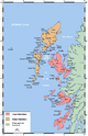
Outer Hebrides Baleshare · Barra · Benbecula · Berneray · Eriskay · Flodaigh · Fraoch-eilean · Great Bernera · Grimsay (North) · Grimsay (South) · Lewis and Harris · North Uist · Scalpay · South Uist · VatersayIslands of Scotland Northern Isles 
Hebrides Other Coordinates: 56°38′00″N 6°33′26″W / 56.6333333°N 6.55722°W
Categories:- Coll
- Islands of the Inner Hebrides
- Ramsar sites in Scotland
- Special Protection Areas in Scotland
- Royal Society for the Protection of Birds reserves in Scotland

Wikimedia Foundation. 2010.