- Danna, Scotland
-
Danna Location 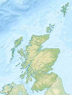
 Danna
DannaDanna shown within Scotland OS grid reference NR695785 Names Gaelic name Danna Pronunciation [t̪an̪ˠə] (  listen)
Meaning of name Of unclear Norse origin Area and summit Area 315 ha (1.22 sq mi) Area rank 83 Highest elevation 54 m (177 ft) Population Population 5 Population rank 80= out of 97 Groupings Island group Islay Local Authority Argyll and Bute 

References [1][2][3][4] If shown, area and population ranks are for all Scottish islands and all inhabited Scottish islands respectively. Population data is from 2001 census. 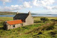 An empty farm house on Danna
Danna Island (Scottish Gaelic: Danna) is a tidal island in Argyll and Bute. It is connected to the mainland by a stone causeway and is at the southern end of the narrow Tayvallich peninsula, which separates Loch Sween from the Sound of Jura.[5] It is part of the Ulva, Danna and the MacCormaig Isles SSSI.[6] Danna is part of the Knapdale National Scenic Area, one of 40 in Scotland.[7]
Footnotes
- ^ 2001 UK Census per List of islands of Scotland
- ^ Haswell-Smith, Hamish (2004). The Scottish Islands. Edinburgh: Canongate. ISBN 1841954543.
- ^ Ordnance Survey
- ^ Iain Mac an Tailleir. "Placenames". Pàrlamaid na h-Alba. http://www.scottish.parliament.uk/vli/language/gaelic/pdfs/placenamesC-E.pdf. Retrieved 2007-07-23.
- ^ Murray, W.H. (1977) The Companion Guide to the West Highlands of Scotland. London. Collins. Page 89.
- ^ SSSI Designation. The nearby Ulva Islands should not be confused with Ulva near Mull.
- ^ "National Scenic Areas". SNH. Retrieved 30 Mar 2011.
National Scenic Areas in Scotland The Borders Firth of Clyde and Mainland Argyll Stirling Perth and Kinross Grampians Highland Assynt-Coigach • Ben Nevis and Glen Coe • Dornoch Firth • Glen Affric • Glen Strathfarrar • Kintail • Knoydart • Kyle of Tongue • Loch Shiel • Morar, Moidart and Ardnamurchan • North-West Sutherland • Wester RossHebrides The Cuillin Hills • Jura • Lynn of Lorn • Loch na Keal, Isle of Mull • Scarba, Lunga and The Garvellachs • Small Isles • St Kilda • South Lewis, Harris and North Uist • South Uist Machair • TrotternishNorthern Isles Islands of Scotland Northern Isles 
Hebrides Other Coordinates: 55°56′41″N 5°41′27″W / 55.94472°N 5.69083°W
Categories:- Islands of the Inner Hebrides
- Tidal islands of Scotland
- Argyll and Bute geography stubs

Wikimedia Foundation. 2010.