- North Lanarkshire
-
Coordinates: 55°49′44″N 3°55′19″W / 55.829°N 3.922°W
North Lanarkshire
North Lanrikshire
Siorrachd Lannraig a Tuath

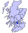
Logo Coat of arms Location 
Geography Area Ranked 19th - Total 470 km2 (181 sq mi) Admin HQ Motherwell ISO 3166-2 GB-NLK ONS code 00QZ Demographics Population Ranked 4th - Total (2005) 326,400 - Density 695 / km² Politics North Lanarkshire Council
http://www.northlan.gov.uk/Control Labour MPs - Tom Clarke
- Gregg McClymont
- Pamela Nash
- Frank Roy
MSPs - John Pentland
- Alex Neil
- Elaine Smith
- Jamie Hepburn
- Michael McMahon
North Lanarkshire (Scots: North Lanrikshire, Scottish Gaelic: Siorrachd Lannraig a Tuath) is one of 32 council areas in Scotland. It borders onto the northeast of the City of Glasgow and contains much of Glasgow's suburbs and commuter towns and villages. It also borders Stirling, Falkirk, East Dunbartonshire, West Lothian and South Lanarkshire. The council covers parts of the traditional counties of Lanarkshire, Dunbartonshire, and Stirlingshire.
The area was formed in 1996, largely from the Cumbernauld and Kilsyth, Motherwell and Monklands districts and significant elements of Strathclyde Regional Council.
Contents
Principal towns (10,000+)
- Airdrie
- Bellshill
- Coatbridge
- Cumbernauld
- Kilsyth
- Motherwell
- Wishaw
Small towns and villages
- Croy
- Dullatur
- Forrestfield
- Garrion Bridge
- Gartcosh
- Glenboig
- Glenmavis
- Greengairs
- Harthill
- Hareshaw
- Holytown
- Longriggend
- Luggiebank
- Mollinsburn
- Moodiesburn
- Mossend
- Muirhead
- Newmains
- Newhouse
- Newarthill
- New Stevenston
- Overtown
- Plains
- Queenzieburn
- Ravenscraig
- Riggend
- Salsburgh
- Shotts
- Stand
- Stepps
- Tannochside
- Viewpark
- Wattston
- Waterloo
Council political composition
North Lanarkshire Local Election Result 2007 Party Seats Gains Losses Net gain/loss Seats % Votes % Votes +/- Labour 40 N/A N/A -14 57.1 49.6 60673 SNP 23 N/A N/A +11 32.9 31.7 38809 Independent 5 N/A N/A -1 7.1 7.0 8510 Conservative 1 N/A N/A +1 1.4 7.5 9212 Liberal Democrats 1 N/A N/A +1 1.4 1.8 2232 Scottish Socialist 0 N/A N/A 0 0.0 1.5 1848 Solidarity 0 N/A N/A 0 0.0 0.6 759 Scottish Christian 0 N/A N/A 0 0.0 0.3 348 External links
Principal Towns (Over 10,000) 
Other towns and villages Allanton · Auchinloch · Annathill · Banton · Bargeddie · Bonkle · Cambusnethan · Cardowan · Calderbank · Caldercruix · Carfin · Carnbroe · Chapelhall · Chryston · Cleland · Forrestfield · Garrion Bridge · Gartcosh · Glenboig · Harthill · Holytown · Longriggend · Mollinsburn · Moodiesburn · Mossend · Muirhead · Newarthill · Newhouse · Newmains · New Stevenston · Overtown · Plains · Queenzieburn · Ravenscraig · Riggend · Salsburgh · Shotts · Stepps · ViewparkPlaces of interest Airdrie Public Observatory · Bedlay Castle · Carfin Grotto · Clyde Valley · Dalzell House · Dalziel Park · Drumpellier · M&Ds · Newhouse Research Site · Ravenscraig Regional Sports Facility · Summerlee, Museum of Scottish Industrial Life · Strathclyde Country Park ·Council areas of Scotland Aberdeen · Aberdeenshire · Angus · Argyll and Bute · Clackmannanshire · Dumfries and Galloway · Dundee · East Ayrshire · East Dunbartonshire · East Lothian · East Renfrewshire · Edinburgh · Falkirk · Fife · Glasgow · Highland · Inverclyde · Midlothian · Moray · Na h-Eileanan Siar (Western Isles) · North Ayrshire · North Lanarkshire · Orkney · Perth and Kinross · Renfrewshire · Scottish Borders · Shetland · South Ayrshire · South Lanarkshire · Stirling · West Dunbartonshire · West Lothian
Categories:- North Lanarkshire
- Council areas of Scotland
Wikimedia Foundation. 2010.
