- Mollinsburn
-
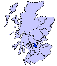
Mollinsburn is a settlement in the North Lanarkshire area of Scotland. It is situated on the A80 road between Condorrat to the east and Moodiesburn to the west. The population is around 100.
The Mollinsburn interchange just west of the settlement currently links the A80 with the M73 motorway. The M80 extension, due for opening in 2011, will depart the present route of the A80 shortly before the current M73 interchange.[1]
The Antonine Wall passes close to Mollinsburn and there is a small fort at Mollins, 4 kilometers south of the wall, which was discovered by aerial photography in 1977.[2]
Notes
- ^ "M80 Stepps to Haggs: The Route". Transport Scotland. http://www.transportscotland.gov.uk/projects/m80-stepps-to-haggs/the-route. Retrieved 2009-12-11.
- ^ "Mollins". ScotlandsPlaces. http://www.scotlandsplaces.gov.uk/search_item/index.php?service=RCAHMS&id=45931. Retrieved 2009-12-11.
Coordinates: 55°55′16″N 4°03′11″W / 55.9212°N 4.053°W
Principal Towns (Over 10,000) 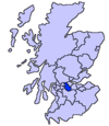
Other towns and villages Allanton · Auchinloch · Annathill · Banton · Bargeddie · Bonkle · Cambusnethan · Cardowan · Calderbank · Caldercruix · Carfin · Carnbroe · Chapelhall · Chryston · Cleland · Forrestfield · Garrion Bridge · Gartcosh · Glenboig · Harthill · Holytown · Longriggend · Mollinsburn · Moodiesburn · Mossend · Muirhead · Newarthill · Newhouse · Newmains · New Stevenston · Overtown · Plains · Queenzieburn · Ravenscraig · Riggend · Salsburgh · Shotts · Stepps · ViewparkPlaces of interest Airdrie Public Observatory · Bedlay Castle · Carfin Grotto · Clyde Valley · Dalzell House · Dalziel Park · Drumpellier · M&Ds · Newhouse Research Site · Ravenscraig Regional Sports Facility · Summerlee, Museum of Scottish Industrial Life · Strathclyde Country Park ·Categories:- Villages in North Lanarkshire
- West of Scotland geography stubs
Wikimedia Foundation. 2010.