- Oneida Carry
-
Oneida Carry — Portage — Map Depicting the Siege of Fort Stanwix and the Oneida Carry Nickname(s): Deo-Wain-Sta or "The Great Carrying Place" Location within the state of New York Coordinates: 43°13′N 75°28′W / 43.217°N 75.467°W Country United States State New York County Oneida City City of Rome Elevation 456 ft (139 m) Contents
Overview
The Oneida Carry was an important link in the trade route between Albany, New York, Oneida Lake, and Lake Ontario during the 18th Century. Linking the Mohawk River and Wood Creek the carry was a vital spot on the Mohawk River Transportation Route, one of two routes in the northern part of the continent that allowed direct access into the western interior of the continent, the other being the Saint Lawrence River. Throughout the 18th Century merchants and soldiers would have to remove their bateaus, a special type of boat for inland transportation, from the water and portage or carry them across the dry land, approximately 2 to 4 miles depending on the water levels. Thus for nearly a hundred years movement of military goods, trade goods, and other supplies into and out of the interior of the North American Continent required control over the Oneida Carry.
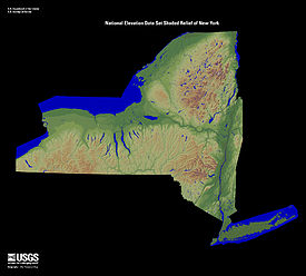
 The Mohawk Valley, running east and west, cuts a natural pathway between the Catskill Mountains to the south and the Adirondack Mountains to the north
Initially held by Great Britain, and then by the United States during and after the American Revolution, the Oneida Carry was seemingly always under a state of improvement. As of today the carry has seen seven fortifications, two supply depots, a variety of canals, and an Air Force Base.
Early Development and French and Indian War
Interest in improving transportation across the Oneida Carry began as early as 1702 when merchants petitioned Governor Cornbury to have improvements made to allow easier passage of boats. As at this time the Oneida Carry was nothing more than a path between the two bodies of water. Although important to trade it wasn't until the beginning of the French and Indian War that the Oneida Carry was finally improved with fortifications, supplies, and dams.
Following the failure of British campaign plans in 1755, a chain of forts along the Mohawk River and up to Lake Ontario were garrisoned during the winter of 1755–1756 to protect the route from a French Invasion and provide a staging area for the invasion of New France. The largest garrison was left at Fort Oswego, at the end of the chain, which depended on the others for its supplies. The two forts occupying either end of the Oneida Carry were a key element of this supply chain. Fort Williams, on the Mohawk, was the larger of the two, while Fort Bull, on Wood Creek, was little more than a palisade surrounding storehouses. In March of 1756 this palisade, holding a large amount of supplies for Fort Oswego, would be the scene of the first battle, known to history, to take place on the Oneida Carry. The Battle of Fort Bull lasted only one day, but saw the entire fortification, and the supplies within, destroyed when its Powder Magazine exploded.
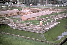
Starting in May 1756 the British refortified the Oneida Carry by adding Fort Craven, Fort Newport, and Fort Wood Creek. However, these forts would only remain until August of 1756, when they were destroyed by the British themselves in anticipation of a massive attack by the French Army and Marines after the capture of Fort Oswego. Direct control of the Oneida Carry by the British would not be re-established until two years later with the construction of Fort Stanwix in August of 1758.
American Revolution
Between the end of the French and Indian War and the beginning of the American Revolution the Oneida Carry transformed from a place of war to a place of peace. After Pontiac's Rebellion the British slowly abandoned Fort Stanwix; its believed the last Half Pay Officer left the Fort in June of 1774 when Governor William Tryon declared the fort "dismantled". During the inner-war period the carry also became home to the Roof Family- who would establish a tavern, continued to be utilized by merchants to move trade goods into the interior of the continent, and in 1768 saw the signing of the Treaty of Fort Stanwix.
However, during the American Revolutionary War the Oneida Carry once again became a battle ground. With Patriot Forces occupying the carry in August of 1776 the Army only had a year to reconstruct Fort Stanwix before the British arrived and laid siege to Fort Stawnix (August 2, 1777 to August 22, 1777). After the successfully defense of Fort Stanwix the Oneida Carry saw little military action. In the spring of 1779, as a part of the Sullivan Expedition of 1779, the American Army used the fort as a staging ground for the destruction of Onondaga Castle. In 1780 the garrison was attacked by a large force of Natives led by Joseph Brant forcing a three day standoff between the Patriot Troops in the well defended Fort Stanwix and the poorly defended Loyalist Natives. In general the most military action seen by the garrison was the occasional harassment by bands of Loyalist Raiding Parties moving into the Mohawk Valley. Which is not to downplay the many lives lost by those soldiers who were unexpectedly attacked, but to re-enforce the idea that garrison duty on the carry became extremely boring. Finally, in the spring of 1781, when flood and fire (most likely arson) destroyed most of the fort, the American Troops evacuated the post; only to return in 1784 to sign the Second Treaty of Fort Stanwix, ending the American Revolution with those Native Americans who sided with the British.
19th Century and Beyond
After the war the Oneida Carry continued to be of economic importance. Established in 1792 the Western Inland Lock Navigation Company constructed a canal between the Mohawk River and Wood Creek. With this canal boats no longer had to be removed from the River and carried over the portage. These canals would have continued use until 1817 when the Erie Canal began construction within the new City of Rome.
The carry also saw a continuation of its military importance throughout the 1800s and up to the 21st Century. Built in 1813 and used until 1873, the Rome Arsenal was a three-acre fortification complex which included barracks, arsenal, magazine, workshops, and other buildings, built to support American forces waging the War of 1812, Mexican–American War, and the American Civil War. This post actually replaced an early armory, constructed and utilized in the late 1790s which was located on the site of, the then demolished, Fort Stanwix.
Starting on 3 April 1941, the War Department began looking for an area to construct an Air Depot in central New York and thus the Oneida Carry would once again become an important part of the Nations Defense. Opened in February 1942 Griffiss Air Force Base would become home to the Rome Labs, the 416th Air Expeditionary Group and Strategic Air Command. Currently the now closed Air Force Base is the home for the Northeast Air Defense Sector facilities which provides detection and air defense for the entire eastern half of the United States.
Lastly with a population of approximately 32,850 people during the 2000 census, and enough land mass (75.7 square miles) to be the second largest city in the State of New York, the City of Rome encompasses most of what was once the Oneida Carry.
Categories:- Colonization history of the United States
- Portages in the United States
- Portages
- Trade routes
- Water transport
- Rivers of New York
- French and Indian War
- Anglo-French Wars
- Geography of Oneida County, New York
Wikimedia Foundation. 2010.


