- Zhumadian
-
Zhumadian
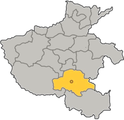
驻马店— Prefecture-level city — 驻马店市 Zhumadian in Henan Location in China Coordinates: 32°59′N 114°02′E / 32.983°N 114.033°ECoordinates: 32°59′N 114°02′E / 32.983°N 114.033°E Country China Province Henan Area – Prefecture-level city 14,974 km2 (5,781.5 sq mi) – Urban 770 km2 (297.3 sq mi) – Metro 770 km2 (297.3 sq mi) Population (2010 census) – Prefecture-level city 7,230,744 – Density 482.9/km2 (1,250.7/sq mi) – Urban 508,312 – Urban density 660.1/km2 (1,709.8/sq mi) – Metro 508,312 – Metro density 660.1/km2 (1,709.8/sq mi) Time zone China Standard (UTC+8) Postal code 463000 Area code(s) 396 GDP ¥4,184 per capita (2003) Major Nationalities Han County-level divisions 10 Mayor Guoqing Liu Township-level divisions Unknown License plate prefixes 豫Q Website http://www.zhumadian.gov.cn Zhumadian (simplified Chinese: 驻马店; traditional Chinese: 駐馬店; pinyin: Zhùmǎdiàn; Postal map spelling: Chumatien) is a prefecture-level city in southern Henan province, People's Republic of China. It borders Xinyang to the south, Nanyang to the west, Pingdingshan to the northwest, Luohe to the north, Zhoukou to the northeast, and the province of Anhui to the east.
Its population is 7,230,744 at the 2010 census whom 503,812 live in the built up area.
Contents
Administrative divisions
The prefecture-level city of Zhumadian administers 1 district and 9 counties.
- Yicheng District (驿城区)
- Runan County (汝南县)
- Pingyu County (平舆县)
- Xincai County (新蔡县)
- Shangcai County (上蔡县)
- Xiping County (西平县)
- Suiping County (遂平县)
- Queshan County (确山县)
- Zhengyang County (正阳县)
- Biyang County (泌阳县)
History
Zhumadian was previously known as Yicheng, for it used to be a relay station. In the Tang Dynasty, the emperor ordered his soldiers carry lychees from Guangdong to his charming princess Yang who loved to eat lychees. And Zhumadian was one of the relay stations.
Geography
Zhumadian is situated at 32° 18' -- 33° 35' N latitude, and 113° 10' -- 115° 12' E longitude, with a maximum east-west width of 191.5 kilometres (119.0 mi), and at most 137.5 kilometres (85.4 mi) long from south to north. The area of the prefecture is 15,083 square kilometres (5,824 sq mi), occupying 8.9% of the total provincial area. Neighbouring prefectures are:
- Fuyang, Anhui (E)
- Xinyang (S)
- Nanyang (W)
- Pingdingshan (NW)
- Luohe (N)
- Zhoukou (NE)
The terrain is dominated by mountains, hills, hillocks, and plains.
Climate
Zhumadian has a four-season, monsoon-influenced humid subtropical climate (Koppen Cwa), with cold, somewhat damp, winters, and hot, humid summers. Monthly mean temperatures range from 1.3 °C (34.3 °F) in January to 27.2 °C (81.0 °F) in July, with an annual mean of 14.9 °C (58.8 °F). Sunshine amounts are moderate and precipitation is concentrated from June to September.
Climate data for Zhumadian (1971−2000) Month Jan Feb Mar Apr May Jun Jul Aug Sep Oct Nov Dec Year Average high °C (°F) 6.4
(43.5)8.9
(48.0)13.8
(56.8)21.2
(70.2)26.4
(79.5)30.9
(87.6)31.9
(89.4)30.8
(87.4)26.9
(80.4)21.7
(71.1)14.8
(58.6)8.9
(48.0)20.2 Average low °C (°F) −2.7
(27.1)−0.8
(30.6)3.6
(38.5)9.9
(49.8)15.0
(59.0)20.3
(68.5)23.4
(74.1)22.3
(72.1)17.2
(63.0)11.3
(52.3)4.8
(40.6)−0.8
(30.6)10.3 Precipitation mm (inches) 21.4
(0.843)25.0
(0.984)51.3
(2.02)58.2
(2.291)84.3
(3.319)130.0
(5.118)194.4
(7.654)180.5
(7.106)106.7
(4.201)71.8
(2.827)39.2
(1.543)16.4
(0.646)979.2
(38.551)% humidity 69 69 71 71 71 70 81 83 78 73 71 67 72.8 Avg. precipitation days (≥ 0.1 mm) 5.3 5.9 8.6 7.9 9.8 9.2 12.7 11.3 9.5 8.7 6.2 4.9 100.0 Sunshine hours 129.8 122.6 144.0 178.9 192.9 194.9 183.8 176.4 159.4 157.8 144.4 141.8 1,926.7 Source: China Meteorological Administration Agriculture
Mainly wheat, maize, peanut, sesame, green beans and tobacco.
Culture
Zhumadian has a rich cultural history and the birthplace of many great people in ancient times[citation needed]. There is an old site of Liang Shanbo and Zhu Yingtai who are the characters in the Butterfly Lovers, a famous Chinese story.
Dams
Zhumadian has 62 different dams including Banqiao Dam within its territory.
Transportation
One of the Chinese main highways, China National Highway 107, runs through Zhumadian. Zhumadian also has its own transportation system.
External links
- Government website of Zhumadian (in Simplified Chinese)
Henan topics General Geography Education Culture Cuisine Visitor attractions Gaocheng Astronomical Observatory • Mount Song • Shaolin Temple • Longmen Grottoes • Songyue Pagoda • Youguo Temple • White Horse TempleHenan Province county-level divisions Zhengzhou: Zhongyuan District · Erqi District · Guancheng Hui District · Jinshui District · Shangjie District · Huiji District · Xinzheng City · Dengfeng City · Xinmi City · Gongyi City · Xingyang City · Zhongmu County
Kaifeng: Gulou District · Longting District · Shunhe Hui District · Yuwangtai District · Jinming District · Qi County · Tongxu County · Weishi County · Kaifeng County · Lankao County
Luoyang: Xigong District · Laocheng District · Chanhe Hui District · Jianxi District · Jili District · Luolong District · Yanshi City · Mengjin County · Xin'an County · Luanchuan County · Song County · Ruyang County · Yiyang County · Luoning County · Yichuan County
Pingdingshan: Xinhua District · Weidong District · Zhanhe District · Shilong District · Wugang City · Ruzhou City · Baofeng County · Ye County · Lushan County · Jia County
Anyang: Beiguan District · Wenfeng District · Yindu District · Long'an District · Linzhou City · Anyang County · Tangyin County · Hua County · Neihuang County
Hebi: Qibin District · Shancheng District · Heshan District · Xun County · Qi County
Xinxiang: Weibin District · Hongqi District · Fengquan District · Muye District · Weihui City · Huixian City · Xinxiang County · Huojia County · Yuanyang County · Yanjin County · Fengqiu County · Changyuan County
Jiaozuo: Jiefang District · Shanyang District · Zhongzhan District · Macun District · Mengzhou City · Qinyang City · Xiuwu County · Bo'ai County · Wuzhi County · Wen County
Puyang: Hualong District · Qingfeng County · Nanle County · Fan County · Taiqian County · Puyang County
Xuchang: Weidu District · Yuzhou City · Changge City · Xuchang County · Yanling County · Xiangcheng County
Luohe: Yuanhui District · Yancheng District · Shaoling District · Wuyang County · Linying County
Sanmenxia: Hubin District · Yima City · Lingbao City · Mianchi County · Shan County · Lushi County
Nanyang: Wolong District · Wancheng District · Dengzhou City · Nanzhao County · Fangcheng County · Xixia County · Zhenping County · Neixiang County · Xichuan County · Sheqi County · Tanghe County · Xinye County · Tongbai County
Shangqiu: Liangyuan District · Suiyang District · Yongcheng City · Yucheng County · Minquan County · Ningling County · Sui County · Xiayi County · Zhecheng County
Xinyang: Shihe District · Pingqiao District · Xi County · Huaibin County · Huangchuan County · Guangshan County · Gushi County · Shangcheng County · Luoshan County · Xin County
Zhoukou: Chuanhui District · Xiangcheng City · Fugou County · Xihua County · Shangshui County · Taikang County · Luyi County · Dancheng County · Huaiyang County · Shenqiu County
Zhumadian: Yicheng District · Queshan County · Biyang County · Suiping County · Xiping County · Shangcai County · Runan County · Pingyu County · Xincai County · Zhengyang County
Jiyuan: (no intermediate County-level divisions, see Administration of Jiyuan)Categories:- Cities in Henan
Wikimedia Foundation. 2010.


